A continental country held together by a federal union, migration and shared institutions, where regional landscapes and histories remain unmistakably distinct.
Area9.83 m km²about half the size of Russia; about three-tenths the size of Africa; about half the size of South America (or slightly larger than Brazil); slightly larger than China; more than twice the size of the European Union
▼ -86 mDeath Valley (lowest point in North America)760 mMean▲ 6,190 mSummit
Climate
Mostly temperate, but tropical in Hawaii and Florida, arctic in Alaska, semiarid in the great plains west of the Mississippi River, and arid in the Great Basin of the southwest; low winter temperatures in the northwest are ameliorated occasionally in January and February by warm chinook winds from the eastern slopes of the Rocky Mountains
Terrain
Vast central plain, mountains in west, hills and low mountains in east; rugged mountains and broad river valleys in Alaska; rugged, volcanic topography in Hawaii
Missouri - 3,768 km, Mississippi - 3,544 km, Yukon river mouth - 3,190 km, Saint Lawrence - 3,058 km+ 4 moreShow lessRio Grande river source (mouth shared with Mexico) - 3,057 km, Colorado river source - 2,333 km, Arkansas - 2,348 km, Columbia river mouth - 2,250 km
Unemployment
4.2% (2025)
Major lakes
Michigan – 57,750 sq km, Superior* – 53,348 sq km, Huron* – 23,597 sq km, Erie* – 12,890 sq km+ 4 moreShow lessOntario* – 9,220 sq km, Lake of the Woods – 4,350 sq km, Iliamna – 2,590 sq km, Okeechobee – 1,810 sq km
Human Development Index
0.921 (2021)
Life expectancy
78.9 years (2024)
Median age
39.5 years (2025 est.)
Administrative subdivisions
51 first-order regions
Urban population
Urban 83.3%Rural 16.7%(2023)
UNESCO World Heritage
28 sites
Major urban areas
New York-Newark (18.937 m), Los Angeles-Long Beach-Santa Ana (12.534 m), Chicago (8.937 m), Houston (6.707 m)+ 2 moreShow lessDallas-Fort Worth (6.574 m), Washington, D.C. (capital) (5.490 m)
Plug types
NEMA 5-15, NEMA 1-15
Ethnic groups
White 61.6%, Black or African American 12.4%, Asian 6%, Indigenous and Alaska native 1.1%, Native Hawaiian and Other Pacific Islander 0.2%, other 8.4%, two or more races 10.2% (2020 est.)
Religions
Protestant 46.5%, Roman Catholic 20.8%, Jewish 1.9%, Church of Jesus Christ 1.6%, other Christian 0.9%, Muslim 0.9%, Jehovah's Witness 0.8%, Buddhist 0.7%, Hindu 0.7%, other 1.8%, unaffiliated 22.8%, don't know/refused 0.6% (2014 est.)
Railways & airports
293,564 km of rail · 16,116 airports
Mains voltage
120 V
Emergency numbers
911
Internet domain
.us
ISO & UN codes
US · USA · M49 840
Name origin
The name America was first used in 1507 and is derived from the first name of Amerigo Vespucci (1454-1512), an Italian explorer, navigator, and cartographer; the name United States first appeared in a document subtitle during the discussions that led to the Declaration of Independence in 1776
Names in other languages
Vereinigte Staaten, 미국, アメリカ合衆国, Estados Unidos, США, États-Unis+ 21 moreShow lessഅമേരിക്കൻ ഐക്യനാടുകൾ, Verenigde Staten, 美國, Stati Uniti, Stany Zjednoczone, ایالات متحده آمریکا, الولايات المتحدة, মার্কিন যুক্তরাষ্ট্র, યુનાઇટેડ સ્ટેટ્સ ઓફ અમેરિકા, संयुक्त राज्य, Amerika Serikat, ಅಮೇರಿಕ ಸಂಯುಕ್ತ ಸಂಸ್ಥಾನ, अमेरिकेची संयुक्त संस्थाने, ਸੰਯੁਕਤ ਰਾਜ ਅਮਰੀਕਾ, அமெரிக்க ஐக்கிய நாடு, అమెరికా సంయుక్త రాష్ట్రాలు, สหรัฐอเมริกา, Amerika Birleşik Devletleri, Сполучені Штати Америки, ریاستہائے متحدہ امریکا, Hoa Kỳ
Neighbours from Wikidata (land borders and some sea borders; only places with a page here); border lengths from the CIA World Factbook.
Facts: Wikidata Q30, World Bank Open Data (CC BY 4.0: population, economy, life expectancy) and the CIA World Factbook (public domain: geography, demographics, borders, coastline and symbols), retrieved 1 November 2026. Figures can change; check the source for the latest.
FLAG & SYMBOLS
The flag and symbols of United States
The flag
13 equal horizontal stripes of red (top and bottom) alternating with white; a blue rectangle in the upper-left corner has 50 five-pointed white stars, arranged in nine offset horizontal rows of six stars (top and bottom) alternating with rows of five stars.
What it means
The stars represent the 50 states, and the stripes represent the 13 original colonies; blue stands for loyalty, devotion, truth, justice, and friendship; red for courage, zeal, and fervency; white for purity and rectitude of conduct.
4 July 1776 (declared independence from Great Britain); 3 September 1783 (recognized by Great Britain)
Flag description and meaning, colours, symbols, anthem details, national day and independence: CIA World Factbook (public domain). Coat of arms, motto and recording: Wikidata and Wikimedia Commons (credited above). Flag artwork: flag-icons (MIT), retrieved 1 November 2026.
UNESCO WORLD HERITAGE
28 World Heritage Sites in United States
14 Cultural13 Natural1 Mixed4 shared with other countriesFirst listed 1978 · latest 2026
Sites, years and types: the UNESCO World Heritage List via Wikidata, retrieved 1 November 2026; ordered by year listed. Names link to English Wikipedia, or to the UNESCO page when there is no article.
The Landlore · 2161 words · 10 min read · Reviewed 2026-11-07
The Mississippi gathers water from a vast interior and carries it south toward the Gulf of Mexico; its watershed crosses political boundaries that cannot contain it. State lines do something different: they divide authority, laws and many of the services that shape daily life. The United States comes into focus when both maps are visible at once. The country is held together by shared institutions and movement across borders, while its landscapes and local rules pull experience in different directions. That is one reason it can feel familiar through its films, music and products, yet difficult to summarize once you begin moving through it.[13]
The United States occupies much of the middle of North America, with Alaska reaching into the far northwest and Hawaiʻi extending into the Pacific. Its continental scale gathers Atlantic and Pacific coasts, Arctic and subtropical environments, immense river systems, interior plains, deserts, forests and mountain chains into one political union. This range shapes life well beyond scenery. It affects where people settle, what they grow, how they travel, what kinds of work are possible and what hazards communities prepare for. The country is not a single landscape expanded outward; it is a set of ecological and regional worlds connected by institutions, trade, migration and shared arguments about belonging.[1][2]
Expansion, slavery and the making of a continental country
After independence, the United States expanded across the continent through purchases, treaties, annexations, migration and war. Each change enlarged the nation while intensifying disputes over who could control land and whether slavery would be permitted in new territories. The language of opportunity and westward movement is part of the national imagination, but it can hide the people already living on those lands and the force used to remove them. The United States grew through both the arrival of settlers and the displacement of Native communities, with consequences that did not end when the national borders stopped moving.[7]
Deep in the Grand Canyon, the Colorado River cuts through semi-arid rock plateaus that depend on regulated western water storage. Photo: Chad Woodward / Wikimedia Commons · CC BY-SA 4.0
Slavery shaped the country’s economy, politics and social order from the colonial period through the Civil War. Enslaved Africans and their descendants were forced to labor in agriculture, domestic work, skilled trades and many other roles, while building families, spiritual practices, knowledge and forms of resistance under conditions designed to deny them control over their lives. The Civil War ended slavery through the Thirteenth Amendment, and Reconstruction briefly opened new possibilities for Black political participation and institution-building. White supremacist violence and law then worked to restrict those freedoms. The consequences reach into the present through unequal access to land and wealth, the geography of segregation, and continuing struggles over citizenship and public memory.[8]
The Civil Rights Movement challenged segregation and exclusion through organizing, legal action, boycotts, marches, journalism, art and community work. Its history is often told through a small number of celebrated leaders and dramatic events, but change depended on local networks and ordinary people taking repeated risks. The movement also shows how national ideals are tested in particular places: a courthouse, a bus station, a school, a neighborhood or a voting line. The promises of equal protection and political participation did not arrive as a finished settlement. They became standards people could invoke, defend and demand in the face of resistance.
A country made through movement
Movement is one of the strongest threads connecting American regions. People have crossed borders to reach the United States, moved from one part of it to another, or been forced to move through slavery, removal and the loss of homes. Each kind of movement has left different marks. Migration from Europe, Asia, Africa, the Caribbean and Latin America has reshaped cities and rural communities. The Great Migration of Black Americans from the South to northern and western cities changed the cultural and political life of places such as Chicago, Detroit, New York and Los Angeles, even as discrimination continued in the destinations people reached.[9]
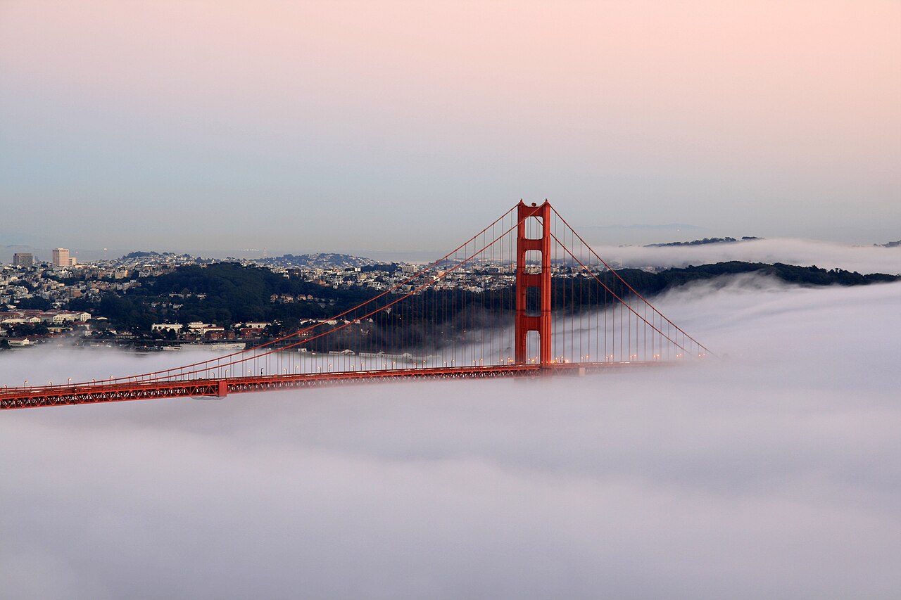
Spanning the opening of San Francisco Bay into the Pacific Ocean, the 1937 Art Deco suspension towers of the Golden Gate Bridge define the gateway of movement across the American West. Photo: Brocken Inaglory / Wikimedia Commons · CC BY-SA 3.0
These movements do not produce a simple story of cultures blending into one. Communities preserve and adapt languages, foodways, faiths, music and ways of working. A neighborhood can hold several generations of a family alongside recent arrivals, students, commuters and people priced out of other districts. In some places, a local identity grows around a particular occupation or landscape: fishing, ranching, logging, mining, farming, shipping or manufacturing. In others, migration has made the city itself a meeting ground of languages and traditions. The Library of Congress’s folklife collections show how expressions of culture are learned in families, work, worship and regional communities, then changed as people meet and borrow from one another.[10]
English is widely used in public life and by most people at home, while many other languages are heard across communities. Spanish has a long history in parts of the present-day United States and is spoken by people with different national, regional and family backgrounds. Chinese languages, Tagalog, Vietnamese, Arabic, French, Korean, Indigenous languages and many others are part of the country’s linguistic landscape. Policies including government-run boarding schools prohibited Native children from speaking their languages; today, Tribal Nations and community organizations continue work to teach and sustain them. The Census Bureau’s language data show how speech varies across states, neighborhoods, generations and households.[7][11][17][21]
Because the country is large and mobility is common, regional identity can be both strong and flexible. Someone may feel rooted in Appalachia, the Gulf Coast, the Navajo Nation, New England, the Great Lakes, the Pacific Northwest or the Rio Grande Valley while also living in a city shaped by newcomers from many places. Regions overlap; their borders are cultural and historical as well as physical. A “South” defined by climate does not map neatly onto one defined by the Civil War, cuisine, music or present-day politics. These regional names open onto local worlds rather than boxing everyone inside them.
Food, belief and the textures of home
Food offers one way to notice how landscape and history meet. Corn, wheat, rice, beans, fish, cattle, citrus, chile peppers and many other ingredients connect regional agriculture and trade to everyday meals. The dishes most readily associated with the United States often have roots in Indigenous knowledge, African American creativity, immigrant adaptation and local resourcefulness. Barbecue, for example, names a wide range of traditions across regions. A smoked meat in the Carolinas, Texas or Kansas City carries different techniques and arguments about what counts as the proper form. Those disagreements are part of the pleasure: food becomes a way people claim a place and tell its history. In an oral history recorded in Enigma, Georgia, barbecue owner Jack Dempsey described learning the craft while working in Texas before opening his own business; a food tradition traveled with a worker and took on a local life.[10][15]
Located within the Navajo Nation on the Arizona-Utah border, the towering sandstone buttes of Monument Valley embody the immense scale and geological drama of the Colorado Plateau. Photo: Warren LeMay / Wikimedia Commons · CC BY-SA 2.0
At the same time, what people eat is shaped by work schedules, income, access to fresh food, family practice and the businesses around them. A holiday meal, a school lunch, a roadside diner and a home kitchen reveal different parts of the country. There is no one national table. Recipes travel, restaurants adapt them, and families make substitutions as ingredients and circumstances change. Across American kitchens, food remains an ongoing record of contact, movement and local invention.
Religion also belongs in an account of the country, without being mistaken for a single public identity. Christian communities have had a major influence on institutions, calendars, education and politics; they include traditions that differ in worship and belief. Jewish life has shaped communities for centuries, and Muslim, Hindu, Buddhist, Sikh, Indigenous, humanist and other spiritual or nonreligious ways of life are part of contemporary society. The First Amendment bars Congress from establishing a religion and protects its free exercise, though the meaning and reach of those protections have been debated. Survey research finds both a large Christian population and a substantial share of adults who identify with no religion; neither label tells us what an individual believes or how faith shapes their daily life.[12][16]
Places of worship can be landmarks, service providers, spaces for mutual aid and settings for music, meals and political discussion. They can also be private places of practice or memory. Some families move between traditions; some keep a faith while changing how they participate; others live without religious affiliation. That diversity lies in the different ways people organize community, mark time, care for one another and understand a life’s responsibilities.
Everyday life beyond the postcard
American life is often pictured through a handful of scenes: a Manhattan street, a small-town main street, a highway diner or a house with a porch. Each exists, but none can stand for the ordinary. Daily routines depend on where people live and what they can reach. For many workers the commute is by car, while transit, walking and cycling are more practical in some large cities. In many suburban and rural communities, homes, jobs, schools and services are spread across distances that make driving part of daily planning. Rural residents may also be far from hospitals and universities. Coastal cities face housing costs and storm risk. Former industrial towns negotiate the loss and reinvention of work. These differences shape how residents experience distance, opportunity and public services.[18]
Along the southwestern shore of Lake Michigan, Chicago grew where Great Lakes shipping met inland rail and canal corridors. Photo: [https://www.mariemillerphotography.com Marie Miller] / Wikimedia Commons · CC BY-SA 4.0
Work is another way the country’s varied geographies become social worlds. Agriculture, energy, manufacturing, logistics, health care, education, government, tourism, finance and technology all organize communities differently. A port city, a farming county and a university town can be connected through national markets while following distinct rhythms. The United States is a major economic power, but that scale can obscure the people whose labor sustains it and the uneven distribution of security and reward. It is possible to encounter extraordinary wealth and deep hardship within the same metropolitan region. The national story of mobility and possibility is meaningful to many people, but it has never guaranteed the same chance to everyone.
Public life is similarly layered. National elections draw attention because the federal government has wide influence at home and abroad. Yet residents encounter politics at school boards, city councils, courts, tribal governments, state legislatures, unions, churches and neighborhood associations. Local debates about roads, libraries, water, housing and schools are not small versions of national debates; they concern the immediate places where people live. For visitors, this is one reason the country can feel simultaneously unified and argumentative. Public disagreement is not an interruption of American life. It is one of the ways people contest the meaning of shared institutions.
Atlas Inquiry: key geographic and cultural questions
How did the construction of the Erie Canal reshape the economic geography of North America?
Completed in 1825, the 363-mile Erie Canal connected the Hudson River at Albany with Lake Erie at Buffalo, creating the first navigable all-water route through the Appalachian Mountains between the Atlantic seaboard and the Great Lakes basin. By cutting freight transportation costs by ninety-five percent and reducing transit times from weeks to days, the canal triggered an agricultural boom across the Midwest and funneled grain, timber, and raw materials eastward. The canal established New York City as the preeminent commercial and financial metropolis of the United States and catalyzed explosive urban growth along its inland route.
What ecological conditions allow the ancient Great Basin bristlecone pines to survive for millennia?
Growing at elevations above ten thousand feet in the White Mountains of California and Nevada, Great Basin bristlecone pines (Pinus longaeva) include individual trees exceeding four thousand eight hundred years of age. Their longevity results from extreme adaptations to a punishing alpine environment characterized by freezing temperatures, dry winds, and nutrient-poor dolomite soils. The trees grow extremely slowly, producing dense, resinous wood that is impervious to fungal decay, pest infestations, and rot. By retaining only a narrow strip of living bark during harsh droughts, these pines survive for millennia while maintaining annual growth ring records.
What urban and ceremonial scale characterized the Mississippian metropolis of Cahokia?
Flourishing between 1050 and 1200 CE across the Mississippi River floodplain near modern Collinsville, Illinois, Cahokia was the largest pre-Columbian urban center north of Mexico, supporting an estimated population of fifteen to twenty thousand residents. The city featured more than one hundred earthen platform mounds arranged around expansive public plazas, dominated by Monks Mound, a colossal four-tiered earthen pyramid rising one hundred feet high. Archaeological excavations revealed sophisticated astronomical calendar woodhenges, extensive copper and shell crafting workshops, and regional trade networks linking the Gulf of Mexico, the Great Lakes, and the Appalachian Mountains.
How does the continental divide separate major river drainage basins across North America?
The Continental Divide of the Americas follows the prominent ridgelines of the Rocky Mountains, serving as the hydrological demarcation line that separates water draining into the Atlantic, Arctic, and Pacific Oceans. Precipitation falling west of the divide flows toward the Columbia, Colorado, and Yukon rivers into the Pacific Ocean or Gulf of California. Moisture falling east of the divide drains through the Missouri, Mississippi, and Rio Grande systems toward the Gulf of Mexico and Atlantic Ocean. This continental divide governs national water rights law, inter-basin water diversions, and regional municipal development across western states.
We are building an open, source-backed atlas of every country, region, ocean and culture — combining verified geographic data with long-form cultural storytelling.
Names and immediate parent assignments: GeoNames, CC BY 4.0, 28 October 2026. Unspecified code 00 excluded. This is not an exhaustive list of districts, counties or municipalities. Photographs are credited individually beneath each image; one pictured place does not represent every landscape in its region.
CONNECTED ACROSS THE ATLAS
Overseas & associated places
Explore separately listed areas with a sourced relationship to United States. These links describe different arrangements, including overseas regions, territories and free association.
Each place links to the primary source for its relationship and status. Geographic location stays separate from constitutional or administrative association.
FROM THE JOURNAL
Stories from United States
Our editorial journey here is still ahead. No researched stories have been published for this place yet.













Share what you know
Been there, grew up there, or know something we missed? Add a comment; corrections with a source are especially welcome.