
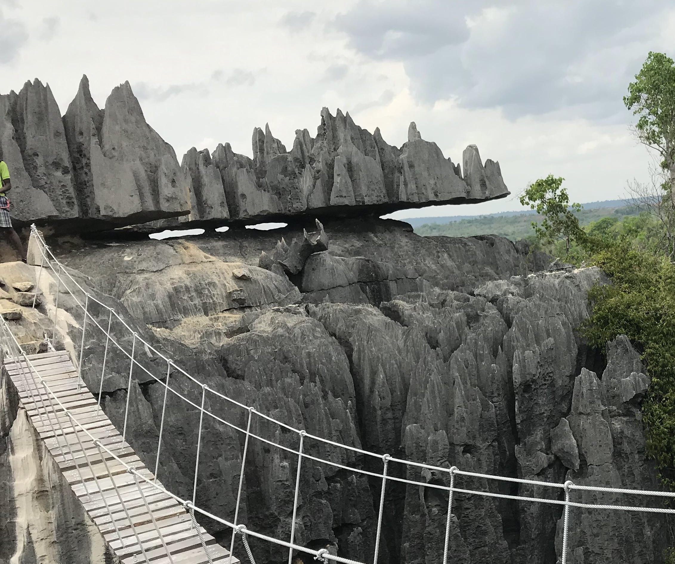
On a 2009 expedition to Madagascar’s Tsingy de Bemaraha, National Geographic writer Neil Shea reported that the limestone pierced the team’s boot soles and cut his knee. The group had spent five days reaching the park’s edge. Stephen Alvarez’s photograph from that trip shows climber John Benson among the pinnacles; the magazine caption gives Benson the nickname “Razor Sharp.” These are accounts of particular people moving through this rock, not a claim that every visitor will be injured.[3][4]
The edge is not only a hazard. Bemaraha’s limestone forms a landscape of narrow blades, deep corridors and caves. The same formations shelter distinctive habitats, while a river gorge and a reported burial place give the stone another human history. To understand the place, separate the slow geological processes that made the karst from present pressures on its wildlife and the meanings people attach to particular sites.
Tsingy is often glossed as “where one cannot walk barefoot,” a popular explanation repeated in National Geographic’s caption. It is not a geological definition, and this source does not establish it as a specialist Malagasy-language translation.[3] The geology is easier to trace. Rock formed in a Middle Jurassic lagoon; later, water worked through it and opened old caves to the sky.
The Tsingy de Bemaraha Strict Nature Reserve dates to 1927. UNESCO inscribed the area in 1990, and part of its southern extent became a national park in 1997. The park includes the Great and Little Tsingy; the Sakalava are the principal people living around the protected area.[2][1] The protected landscape is not an empty wilderness: its boundaries sit beside villages and livelihoods, and access takes place within a lived region.
A lagoon floor turned to limestone
The Bemaraha Formation began as sediment in a coastal barrier and lagoon system. Its rocks date to the early Bajocian through early Bathonian stages of the Middle Jurassic, about 170 to 168 million years ago. The formation includes lime mudstone as well as grainstone and massive limestone, with coral reefs separating lagoons from the open sea.[7] In the eastern belt, fossils include gastropods, bivalves, brachiopods, sea urchins and broken coral. Reef corals and oolites are more prominent to the west. [5][7]
That east-to-west change preserves more than a list of fossils. The eastern beds record a lagoon setting with abundant remains of marine organisms; farther west, the stronger presence of reef material and oolites points to a different part of the same coastal system. These are not separate landscapes stacked together by accident. They belong to a geological formation whose environments varied across space before later uplift and weathering exposed them. The plateau’s present shape is therefore a much younger surface over a record of shallow seas and reef margins.[5][7]

The limestone sequence is hundreds of metres thick. Its beds tilt westward, and the plateau rises from roughly 100 metres in the west to 600 metres in the east before dropping at the Betsiriry Valley scarp.[7] The word “plateau” can suggest a level tableland; Bemaraha’s eastern edge makes clear how much the relief changes across it. The karst is younger than the sedimentary rock: the IUGS account places its development from the Pliocene into the Holocene.[7] Marine sediment built the limestone; much later, water widened its weaknesses into the exposed forms visible now.
Old caves opened into blades
Bemaraha’s pinnacles record a two-stage process. Mapped grikes and cave networks support a model in which cavities formed beneath the karst water table, then reached the surface through dissolution or collapse; rain has continued to widen the exposed fissures.[5][6]
Studies of Ankarana in northern Madagascar give greater weight to surface-cut karren. That comparison helps distinguish two karst landscapes without treating every sharp limestone formation as the same process.[5][6] At Bemaraha, the mapped fissures are called grikes, while karren describes finer grooves and hollows etched into exposed limestone. The distinction is useful at walking scale: broad blocks are split by deep cuts, and their surfaces are marked by smaller channels. Both forms result from water acting on soluble rock, but the mapped cave network gives Bemaraha’s karst a documented subterranean history as well as a visible surface texture.[5][6]

A grike is a deep fissure between limestone blocks; karren are smaller grooves or hollows etched by water at the surface.[5][6]
Reported heights vary by source and by what is being measured. A frog study gives pinnacles reaching 45 metres, while the IUGS account describes peaks rising to about one hundred metres. These figures should not be collapsed into one measurement of a uniform formation.[9][7]
Small habitats above and below the crest
A limestone tower is not one habitat from top to bottom. Summit, slope and base offer different conditions, and the park’s long plateau holds dry deciduous forest alongside humid pockets in larger canyons. Savanna, marshes, caves and gorges surround the karst.[7][11]
A 1996 field journal from the PBS series The Living Edens records a sharp contrast during filming. The crew described the heat on the plateau as intense; after descending into a narrow canyon, they found air at least 20 degrees cooler. The journal also recommends carrying water for a day on the tsingy. This is one crew’s account of conditions during its visit, not a measurement that applies to every season or route.[8]
The IUGS entry calls the karst a water tower for the Antsalova region. Sinkholes, vertical shafts and caves collect and channel water through the limestone, helping create greener pockets within the dry western forest. Wild Madagascar describes a long dry season and records hundreds of plant species and several groups of vertebrates in the park. These regional estimates describe a varied protected area, not a census of every species using one pinnacle.[11]
The World Heritage datasheet adds the larger pattern: rivers cross the plateau before reaching lakes and marshes, while permanent springs rise at the limestone’s base.[16] Together with the subterranean pathways described above, these streams link the high ground with farms and settlements beyond its rim.
The frog Gephyromantis atsingy was described by a team led by Crottini in 2011; its holotype had been collected at Andamozavaky in 2003. Researchers found frogs in caves by day, where they suspected the air was more humid, and on cliffs, rocks and canyon walls at night. They also recorded the species away from open water.[9] The northern part of the reserve had not been properly surveyed, so its full range remains unknown.
A dwarf chameleon and several geckos also live among the karst’s fauna.[10] One of them, Paroedura neglecta, was formally described in 2019 by J. Köhler, M. Vences, M. D. Scherz and F. Glaw. The name “neglected” reflects a gap between discovery and formal description: the animal was recognised as new soon after collection, but imperfect specimens delayed its description.[10] Its taxonomic history is a small reminder that discovery and description are not the same event. A specimen may wait in a collection while researchers weigh the evidence needed to distinguish it from known species.
Lemurs use the forest and the rock
Von der Decken’s sifaka, Propithecus deckenii, is a creamy-white, black-faced lemur of western Madagascar. In trees it clings and leaps; across open ground it can move in two-legged hops with its arms raised. The species lives in dry forest and tsingy, including protected areas such as Bemaraha.[12]

The sifaka is listed as Critically Endangered. The IUCN assessment projects a decline of at least 80 percent between 2020 and 2050, citing charcoal production, logging and pasture clearing among the pressures. Traditional taboos, or fady, offer some protection, though adherence is reported to be weakening. Wild Madagascar also lists the red-fronted brown lemur among the park’s primates.[11] Protecting these animals therefore depends on more than the inaccessibility of the limestone: dry forest, local land use and the rules governing resources beyond the towers also shape their future.[12]
Another lemur entered the scientific record through a slower process. In 1990, a University of Zurich team led by Urs Thalmann recorded an unfamiliar woolly lemur in Bemaraha. Thalmann and Thomas Geissmann described it in 2005 as Avahi cleesei, named for John Cleese and his interest in lemurs and conservation. It is known from a small area within the park north of the Manambolo River and was assessed as Critically Endangered in 2020.[13]
The species records point to different scales of protection. The frog study raises questions about caves, canyon walls and how much of the northern reserve has been surveyed; the sifaka assessment points toward forest conversion and land use outside the sharpest karst.[9][12] A protected limestone corridor may keep some animals difficult to reach, but it cannot substitute for intact forest or a connected catchment. Conservation has to follow the habitat each species uses, rather than assume the pinnacles protect everything around them. The assessment’s call for long-term monitoring matters for that reason: conditions within the reserve and pressures at its edges need to be tracked together.[15] Repeated observations across seasons can reveal changes a single visit cannot show.
Rain changes the scale of the landscape
The plateau does not receive water evenly through the year. The World Heritage datasheet describes a hot wet season from late November to April and a dry season lasting about six months. Annual rainfall is estimated at 1,000 to 1,500 millimetres on the plateau, against 500 to 1,000 millimetres in the western forest.[16] Water scarcity is not uniform here; elevation and position change the conditions around the reserve.
Water follows both the slope and the rock. The World Heritage datasheet distinguishes permanent from seasonal rivers, describes lakes and marshy plains to the west, and notes springs rising at the limestone base.[16] The IUGS account adds the hidden part of that route: sinkholes, shafts and caves channel water through the karst.[11] One description follows surface drainage and springs; the other explains how water enters the limestone. Together they make the plateau part of a regional catchment rather than an isolated wall of stone.
The Manambolo cuts through the karst
The Manambolo River crosses the protected landscape and has cut a canyon about 300 metres deep. The limestone massif changes in height across the plateau, then drops sharply toward the Betsiriry Valley; several major rivers cut through it.[7] The karst is not only a wall of stone. Its fractured rock holds and channels water. From the river, the high cliffs read as a barrier; from the plateau, the gorge is one of the routes the water has made through them. Local people navigate the Manambolo in small wooden pirogues.[14] The canyon makes the region’s relief legible at close range: the river occupies a cut far below the plateau, while tributaries and seasonal flows connect the heights to lower ground. The landscape is therefore experienced in cross-section as much as from above. A boat follows the river corridor; a foot route over the limestone meets a very different terrain and pace. The same massif that can appear continuous on a map is divided by water into distinct approaches and settlements.
The river also gives the plateau a human scale. The IUGS description records limestone peaks and deep clefts, while the World Heritage account places the gorge within a broader drainage system.[7][11] A pirogue moves through a narrow channel beneath steep walls; a visitor standing on the plateau sees a wider horizon and the breaks where rivers have cut through. Those are not competing views. They describe the same relief from different elevations, and help explain why movement across the region depends on where a route begins. The conservation assessment notes established circuits, viewpoints, bridges and community guides, with tourism impacts described as localised. Visitors encounter a managed route through a difficult landscape, while nearby communities are part of the service and protection around it.[15]
A reported burial place above the river
A travel magazine reports a burial place beneath a rock overhang beside the Manambolo and attributes it, in that account, to the Vazimba. It says foreign visitors approach by pirogue with local villagers, who introduce the place through a kabary, a formal speech.[14]
This is a travel magazine’s report, not archaeological documentation or direct testimony from Sakalava custodians. A UNEP-WCMC datasheet separately records ancient cemeteries in the gorge and says the petroglyphs’ attribution to the Vazimba is doubtful.[16] Neither account offers direct testimony from Sakalava custodians or establishes a general belief or access rule; a reported burial place should be treated with care, not as a tourist attraction. The report does, however, describe local villagers mediating the visit, a reminder that access to a site is shaped by people as well as terrain. That detail belongs to this reported encounter; it should not be turned into a rule for other sites or communities.[14]
Natural erosion and habitat loss are different threats
National Geographic’s caption for the Benson photograph says the rugged stone deters hunters, cattle and wildfire. Its gallery contrasts life among the spires with pressures elsewhere in Madagascar. That protection is not absolute, and it should not be confused with the slow erosion that formed the karst.[3][4]
The western part of the park includes tsingy and deciduous forest; the eastern part includes savanna, forest and marsh.[11] Crottini and colleagues reported forest conversion for farmland and charcoal production, and recommended Near Threatened status for Gephyromantis atsingy.[9] The sifaka faces forest loss, hunting and capture for the pet trade.[12]
The 2020 assessment describes management as largely effective, while recommending long-term monitoring, stronger research capacity, clearer boundaries and a compatible buffer zone.[15] It also calls for community participation in ecotourism and ecological monitoring. These are practical local measures: they connect the condition of the protected forest and wetlands to the people who live around the reserve and help shape how it is visited and cared for.[15]




Share what you know
Been there, grew up there, or know something we missed? Add a comment; corrections with a source are especially welcome.