
The Eastern Gulf: Geography, Volcanic Arcs, and Shelf Bathymetry
Bristol Bay forms a colossal, funnel-shaped marine embayment carved into the southwestern flank of Alaska. Opening westward into the broad shallow shelf of the southeastern Bering Sea, this water body extends roughly four hundred kilometers across its marine mouth, measured from the rugged granite headlands of Cape Newenham in the north to the low-lying tundra spit of Cape Menshikof along the northern shore of the Alaska Peninsula. Covering approximately one hundred and twenty thousand square kilometers of subarctic waters, Bristol Bay is framed on its southern margin by the towering volcanic ramparts of the Aleutian Range—whose snow-mantled calderas, including Mount Katmai and Mount Veniaminof, periodically dust the bay’s coastal waters with volcanic ash—while its northern perimeter dissolves into the sprawling lacustrine tundra plains of the Yukon-Kuskokwim and Dillingham regions.
The underwater topography of Bristol Bay is distinguished by its extreme shallowness and gentle slope. Situated entirely atop the continental shelf, water depths throughout the outer bay rarely exceed seventy meters, gradually shoaling eastward toward the interior estuaries where depths diminish to less than twenty meters across thousands of square kilometers. Near the head of the embayment, the marine corridor divides into several major secondary estuaries, most prominently Nushagak Bay to the northwest and Kvichak Bay to the northeast.
These inner estuaries are dominated by shifting underwater sandbanks, alluvial mudbanks, and glacial silt shoals continuously deposited by mainland river discharge. As the powerful tides surge across the shallow shelf, massive quantities of glacial flour and benthic sediments are suspended into the water column, transforming the inland bays into opaque, tea-colored waters where underwater visibility drops to mere centimeters. The seafloor consists predominantly of fine sand, silty clay, and glacial gravels, establishing a resilient benthic substrate that supports rich assemblages of bottom-dwelling invertebrates, including sand dollars, bivalves, and red king crabs.
The sedimentological dynamics of Bristol Bay are shaped by monumental sediment discharges from the volcanic and glaciated mountains flanking the basin. Geomorphologists tracking fluvial discharge estimate that the Kvichak and Nushagak rivers alone convey millions of metric tons of fine glacial rock flour and suspended clay particles into the bay every summer. Because the inner bays are shallow, this relentless terrigenous delivery creates broad, shifting underwater shoals and mudbars that migrate across the navigation channels with every severe storm surge, requiring maritime navigators and commercial fishing skippers to continuously monitor evolving bathymetric soundings.

Hydrodynamics of the Funnel: Macro-Tides, Estuarine Plumes, and Sea Ice
The physical oceanography of Bristol Bay is governed by extreme tidal mechanics and intense seasonal meteorological cycles. As the oceanic tidal wave propagates northward through the Bering Sea basin, it is funneled into the narrowing, shallow confines of Bristol Bay, amplifying tidal amplitudes dramatically. In the outer bay, tidal ranges remain moderate at two to three meters; however, as the water surges into the funnel of Kvichak and Nushagak bays, the tidal oscillation reaches macro-tidal proportions, regularly producing diurnal and semi-diurnal swings exceeding nine to ten meters.
These colossal tides generate ferocious tidal currents that rip through navigational channels at velocities surpassing five to seven knots. As the tide ebbs, immense areas of the upper estuaries drain completely, exposing tens of thousands of hectares of glistening mudflats that remain stranded until the rushing flood tide sweeps back across the flats in a turbulent, foaming wall of water. This ceaseless tidal pumping thoroughly churns the water column, preventing seasonal thermal stratification and keeping the estuarine waters thoroughly oxygenated from surface to seabed.
Freshwater runoff plays an equally pivotal role in shaping the bay’s circulation. A web of nine major river systems discharges an average of over eighty cubic kilometers of pristine freshwater into Bristol Bay annually. This tremendous volume of terrestrial runoff forms a buoyant, low-salinity coastal boundary current known as the Bristol Bay Coastal Current, which hugs the shoreline of the Alaska Peninsula and flows southwestward toward Unimak Pass. During the bitter subarctic winter, which extends from late November through April, the combination of low surface salinity, shallow bathymetry, and freezing Siberian air masses rolling across the Bering Sea causes extensive pack ice and shorefast ice to form across Bristol Bay, locking the river mouths in frozen sheets that grind relentlessly against the coastal shoals.
Physical oceanographers deploying ocean bottom pressure gauges across Bristol Bay have documented the profound role of continental shelf waves in driving water exchange between the open Bering Sea and the inner estuaries. The interaction of the incoming tide with the shoaling seabed generates internal tidal bores that propagate scores of kilometers up the estuaries, generating intense vertical shear that breaks down any temporary thermal stratification. Even during warm summer months with twenty hours of sunlight, water temperatures throughout the water column rarely deviate by more than two to three degrees Celsius from surface to seabed.
Carved by Ice: Quaternary Glaciation and Pristine Watersheds
The contemporary landscape framing Bristol Bay is the direct creation of repeated Quaternary glacial episodes and post-glacial marine inundations. Throughout the Pleistocene epoch, colossal alpine ice sheets accumulated across the Alaska Peninsula and Ahklun Mountains, advancing westward across the lowlands to carve deep glacial troughs and deposit monumental morainal ridges. As the climate warmed and glaciers retreated around twelve thousand years ago, these moraines dammed the glacial meltwaters, creating a constellation of colossal, deep lakes—including Lake Iliamna, Alaska’s largest freshwater lake, Lake Clark, and the Wood-Tikchik lake chain.
Lake Iliamna, spanning over two thousand six hundred square kilometers and plunging to depths exceeding three hundred meters, serves as the hydrological crown of the Bristol Bay basin. The lake functions as an immense settling reservoir: glacial rock flour and coarse terrigenous sediments settle out within its calm depths, allowing clear, nutrient-rich water to flow down the broad, thirty-kilometer-long Kvichak River directly into Kvichak Bay.
Surrounding these lacustrine chains lies an unbroken wilderness of wet subarctic tundra, peat bogs, dwarf birch forests, and white spruce river valleys. Because Southwestern Alaska has remained roadless and geographically isolated from major industrial centers, Bristol Bay’s drainage basin represents one of the most intact and unpolluted macro-watersheds on planet Earth. There are no dams, no artificial channelizations, no commercial timber operations, and no chemical agriculture across its forty thousand square kilometers of drainage territory, preserving the primordial geochemical conditions required for aquatic life to flourish in unprecedented abundance.
The geomorphology of the Bristol Bay coastal plain is defined by extensive peat plateaus, thermokarst thaw lakes, and coastal salt marshes that buffer the interface between land and sea. Permafrost scientists investigating the subarctic tundra surrounding Dillingham and King Salmon have documented that these vast organic soils store enormous reservoirs of ancient biogenic carbon. In the coastal estuaries, broad flats of alkali grass (Puccinellia phryganodes) and carex sedges stabilize tidal mudflats, providing essential nesting habitat for hundreds of thousands of migratory waterfowl, including emperor geese, Pacific black brant, and sandhill cranes.
The Miracle of the Red Run: Sockeye Migrations and Trophic Abundance
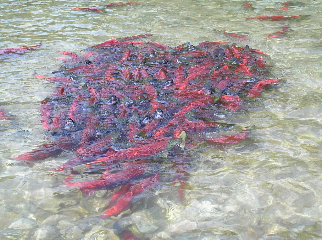
Bristol Bay is celebrated globally as the epicenter of wild Pacific salmon ecology. Every year between late June and mid-July, the bay witnesses the largest wild sockeye salmon (Oncorhynchus nerka) migration on Earth. Millions of adult salmon, having spent two to three years grazing on pelagic zooplankton in the open Gulf of Alaska and North Pacific Ocean, congregate in the outer waters of Bristol Bay. Guided by olfactory imprinting and geomagnetic navigation, they funnel through the estuary, sorting themselves with precision into their natal river systems: the Kvichak, Naknek, Alagnak, Nushagak, Wood, Igushik, Togiak, Egegik, and Ugashik.
In recent decades, annual sockeye returns to Bristol Bay have repeatedly shattered biological records, with total runs frequently exceeding sixty million salmon and reaching an astonishing seventy-nine million fish in the summer of twenty twenty-two. This massive influx of wild biomass drives an extraordinary ecological phenomenon known as marine-derived nutrient transport. As spawning salmon die in the headwater gravel beds, their decaying bodies deposit thousands of metric tons of ocean-derived nitrogen, phosphorus, and carbon into the terrestrial and freshwater ecosystems, fertilizing riparian vegetation, aquatic insects, and juvenile salmon parr.
Beyond salmon, Bristol Bay sustains a rich marine and coastal fauna. The bay’s shallow gravel banks support substantial populations of Pacific herring, yellowfin sole, and red king crab. Marine mammals congregate in immense numbers: beluga whales follow the migrating salmon runs deep into the turbid estuaries of Nushagak and Kvichak, while harbor seals haul out on tidal sandbars. In northern Bristol Bay, the Walrus Islands—a group of seven rugged, granite islands including Round Island—serve as one of the world’s most significant terrestrial haulouts for male Pacific walruses (Odobenus rosmarus divergens), where up to fourteen thousand tusked bulls rest tightly packed along rocky storm beaches between foraging excursions to benthic clam beds.
The genetic architecture of Bristol Bay sockeye salmon represents one of the most remarkable examples of biological portfolio diversity documented in evolutionary biology. Researchers at the University of Washington’s Alaska Salmon Program, who have monitored the watershed continuously since nineteen forty-six, have identified hundreds of distinct, reproductive populations adapted to specific micro-habitats—from fast-flowing glacial rivers to calm, spring-fed gravel streams and lake beaches. This biocomplexity functions like a diversified financial portfolio: while conditions in any individual river may vary due to drought, freezing, or volcanic ash, other stocks thrive, ensuring that the overall run remains extraordinarily resilient year after year.
Deep Roots and Sailboats: Indigenous Stewardship and the Historic Fishery
Human habitation along the shores of Bristol Bay traces back more than eight thousand years. The region is the ancestral homeland of Central Yup’ik, Alutiiq (Sugpiaq), and Dena’ina Athabascan peoples, whose cultures and lifeways evolved in intimate reciprocity with the seasonal pulses of the salmon and sea mammals. Indigenous settlements—such as those at Dillingham, Naknek, Egegik, and Togiak—relied on sophisticated traditional knowledge of tides, ice patterns, and fish movements. Families harvested salmon with split-pole weirs, dip nets, and gillnets, preserving hundreds of pounds of fish in underground smokehouses and drying racks to guarantee winter survival.
European contact began in seventeen seventy-eight when Captain James Cook entered the bay aboard HMS Resolution during his search for the Northwest Passage, naming the seaway Bristol Bay in honor of Augustus Hervey, the Earl of Bristol. Russian fur traders subsequently explored the coastal margins in the early nineteenth century, establishing a trading redoubt at Alexandrovsk (now Dillingham) in eighteen eighteen. However, it was the arrival of the commercial canning industry in the eighteen eighties that transformed the bay into an industrial resource hub.
The Arctic Packing Company established the first salmon cannery on the Nushagak River in eighteen eighty-four. Over the following decades, dozens of massive wooden canneries sprang up along the tundra bluffs, operated by large corporations like the Alaska Packers Association. Until nineteen fifty-two, federal regulations prohibited motorized fishing vessels in Bristol Bay to prevent overfishing; consequently, thousands of fishermen sailed seaworthy twenty-nine-foot double-ended wooden sailboats into the treacherous tidal channels, hauling heavy cotton gillnets entirely by hand under harrowing subarctic weather conditions. Today, Bristol Bay’s commercial fleet consists of modern thirty-two-foot aluminum drift gillnetters and beach setnet operations, sustaining thousands of independent commercial fishing families who harvest salmon with rigorous, scientifically managed escapement quotas.
The traditional seasonal subsistence cycle (yuuyaraq) of the Central Yup’ik along Bristol Bay represents an enduring system of social organization and ecological ethics. Every spring, extended families travel to coastal fish camps along the shores of Nushagak, Togiak, and Egegik, where multiple generations work together to process the salmon run. Women masterfully fillet the fish with curved ulu knives, carefully scoring the red flesh into intricate patterns to facilitate uniform air-drying in smokehouses fueled by sweet coastal driftwood and green willow smoke, ensuring that nutritional and cultural values are transmitted to future generations.
Defending the Headwaters: The Pebble Mine Defense and Future Stewardship
For the past two decades, Bristol Bay stood at the center of one of the most consequential environmental battles in North American history: the struggle over the proposed Pebble Mine. The Pebble deposit, discovered near the divide between the Kvichak and Nushagak watersheds, represents one of the largest undeveloped copper, gold, and molybdenum porphyry ore deposits in the world. Mining consortiums proposed constructing a massive open-pit mine, deep tailings reservoirs, and industrial infrastructure capable of processing billions of tons of low-grade sulfide ore over several decades.
The prospect of mining at the headwaters galvanized an unprecedented coalition of Yup’ik, Dena’ina, and Alutiiq tribal governments, commercial fishing organizations, sports angling lodges, and national conservation groups. Opponents emphasized that the sulfide ore bodies posed severe risks of acid mine drainage and toxic trace metal leaching into the pristine streams that produce the majority of Bristol Bay’s sockeye salmon. Scientific assessments conducted by the U.S. Environmental Protection Agency concluded that even routine mining operations would permanently destroy dozens of miles of critical spawning streams and thousands of acres of contiguous wetlands, while a catastrophic tailings dam breach would irrevocably poison the watershed.
The grassroots resistance culminated in January twenty twenty-three, when the EPA exercised its rare veto authority under Section 404(c) of the Clean Water Act, prohibiting the discharge of dredged or fill material in the waters and wetlands within the Pebble deposit area. This landmark ruling established durable federal protection for the Kvichak and Nushagak headwaters. Today, the communities of Bristol Bay are advancing tribally-led regional watershed protections, climate adaptation strategies to monitor warming lake temperatures, and sustainable fisheries management models, ensuring that this subarctic bay remains the world’s most enduring sanctuary of wild salmon.
The ongoing long-term monitoring of Bristol Bay’s aquatic biomes has established an international benchmark for freshwater ecosystem defense and community-based science. Collaborative research initiatives between regional tribal consortia, university marine laboratories, and federal wildlife biologists utilize environmental DNA (eDNA) sampling to map juvenile salmonid distribution across thousands of remote headwater streams. By pairing cutting-edge genomics with generations of Indigenous seasonal observation, these programs ensure that potential industrial encroachment is detected early, safeguarding the pristine water chemistry that sustains the planet’s greatest wild sockeye salmon migration.
Sources & credits1 references
Written sources
- Array
Last fact review: 2026-11-09 · Sources checked manually; facts are not automatically updated.
Image credits
- Photo: U.S. Army Corps of Engineers / Wikimedia Commons Image licencePublic domainPhotograph by U.S. Army Corps of Engineers / Wikimedia Commons. Display crop may differ from the original.
- Photo: U.S. Environmental Protection Agency / Wikimedia Commons Image licencePublic domainPhotograph by U.S. Environmental Protection Agency / Wikimedia Commons. Display crop may differ from the original.
Frequently Asked Questions
Where is Bristol Bay located and what are its geographic limits?
Bristol Bay is an expansive eastern arm of the Bering Sea indented into southwestern Alaska. It is bounded on the south and east by the volcanic spine of the Alaska Peninsula and on the north by the rolling subarctic tundra and mountain ranges of mainland Alaska. The mouth of the bay extends roughly four hundred kilometers across between Cape Newenham in the northwest and Cape Menshikof on the Alaska Peninsula.
Why is Bristol Bay considered the salmon capital of the world?
Bristol Bay is the single most productive wild sockeye salmon (Oncorhynchus nerka) nursery on Earth. The watershed comprises nine major un-dammed river systems—including the Kvichak, Naknek, Nushagak, Egegik, and Ugashik—which drain into expansive oligotrophic tundra lakes with pristine gravel spawning beds. In peak years, more than seventy million wild sockeye return through the bay, producing roughly half of the global commercial harvest of wild sockeye salmon without any artificial hatchery supplementation.
What makes the navigation of Bristol Bay so hazardous?
Navigation in Bristol Bay is notoriously treacherous due to shallow bathymetry, extreme macro-tides, shifting glacial silt bars, and violent Bering Sea gales. In bays like Nushagak and Kvichak, water depths fluctuate by up to ten meters twice daily, turning navigational fairways into drying mudflats within hours. Thick fog, violent williwaw squalls rolling off the Aleutian Range, and seasonal pack ice floes between December and April create formidable maritime risks.
What was the Pebble Mine controversy in Bristol Bay?
The Pebble Mine was a proposed open-pit copper, gold, and molybdenum mine situated at the headwaters of the Kvichak and Nushagak river systems. For over two decades, Indigenous tribes, commercial fishermen, sportsmen, and conservationists campaigned against the project, arguing that toxic mine tailings and catastrophic drainage failures would destroy the headwaters of the world’s most valuable wild salmon fishery. In January 2023, the U.S. Environmental Protection Agency issued a final determination under Clean Water Act Section 404(c), effectively barring the disposal of mine waste in the headwaters and safeguarding the watershed.





Share what you know
Been there, grew up there, or know something we missed? Add a comment; corrections with a source are especially welcome.