
The Undisputed Tidal Colossus
Wedged like an immense geological funnel between the Canadian provinces of Nova Scotia and New Brunswick, the Bay of Fundy forms the stage for the most astonishing physical spectacle in the world’s oceans. Spanning two hundred and seventy kilometers from its wide southwestern entrance at the Gulf of Maine to the bifurcated reaches of Chignecto Bay and the Minas Basin, this body of water holds the undisputed Guinness World Record for the highest tidal range on planet Earth. Along its inner shores, the ocean breathes with a vertical amplitude that defies human comprehension: twice each day, the tide rises and falls by up to sixteen meters—a vertical elevation change greater than a four-story building.
To stand on the red sandstone bluffs of Cape Split or watch the water from the rocky shores of Brier Island is to witness hydraulic power on a planetary scale. Every twelve hours and twenty-five minutes, more than one hundred and sixty billion tons of cold Atlantic seawater rush into the bay, doubling its volume and raising the water level at rates exceeding three vertical meters per hour. This single tidal pulse moves more water than the combined daily discharge of all the freshwater rivers on the globe. As this colossal mass of water surges through narrow coastal channels, it roars with a deep, subterranean rumble, generating standing waves, violent whirlpools, and foaming tidal rips that have commanded the awe of mariners for centuries.
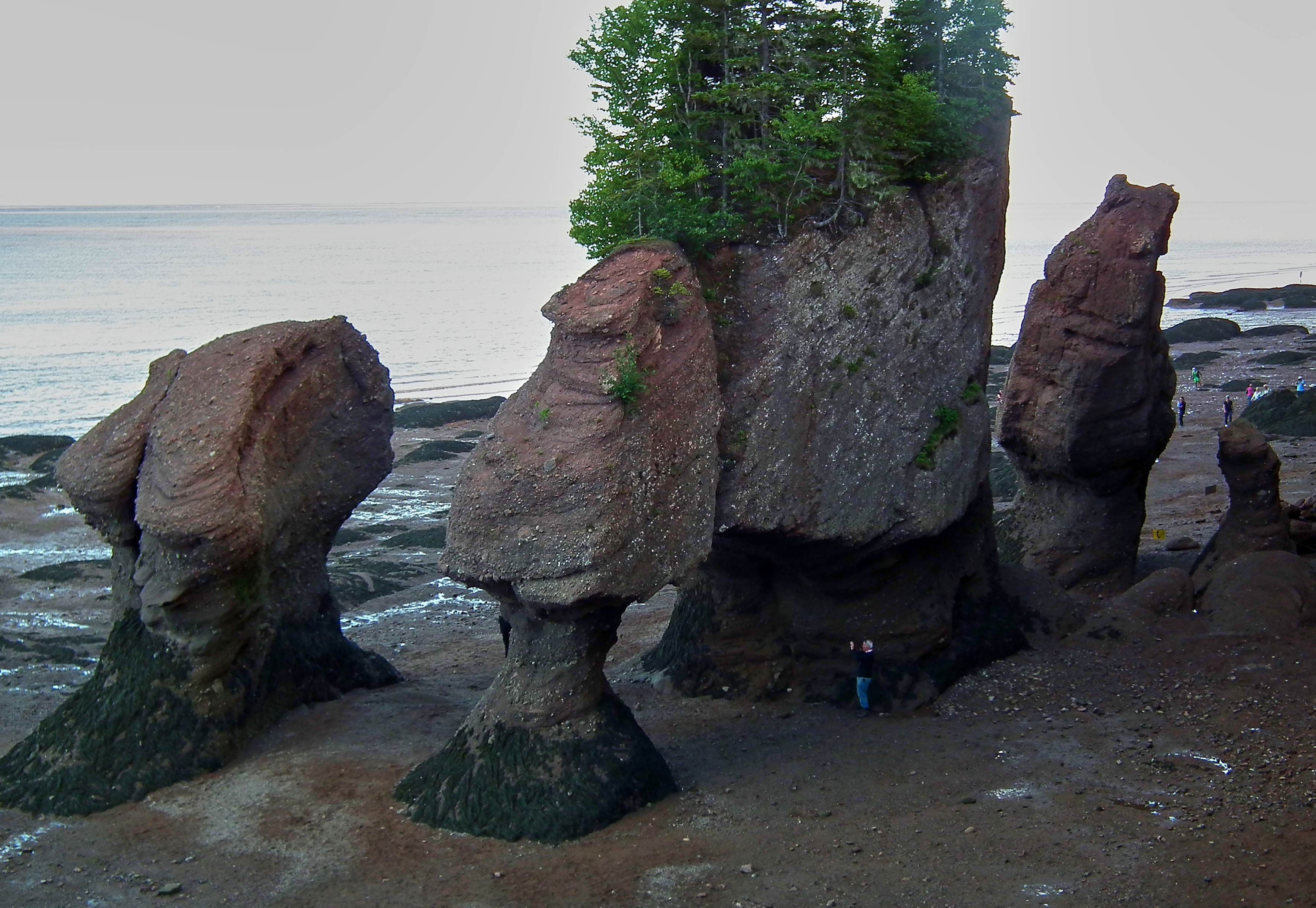
At low tide, the spectacle reverses into an alien, glistening landscape. The sea retreats miles from the cliffs, exposing colossal expanses of intertidal red mudflats, vast fields of rockweed (Ascophyllum nodosum), and soaring sea stacks carved into grotesque hourglass shapes by the swirling water. Vessels moored at wooden fishing piers sit stranded high and dry on wooden cradles perched fifteen meters above the sea floor, awaiting the next thunderous surge of the Atlantic tide.
High-resolution acoustic multibeam bathymetric surveys of the Bay of Fundy floor have revealed monumental subaquatic sediment bedforms created by the ferocious tidal streams. In the Minas Passage, where tidal velocities exceed five meters per second, the seafloor is swept clean to bare volcanic basalt bedrock, flanked by massive underwater gravel dunes and migrating sand waves up to twenty meters high. These subaqueous megadunes march across the seabed with every tidal reversal, demonstrating the colossal kinetic energy continuously shaping the bottom of the bay.
The unique geographic orientation of the Bay of Fundy plays a decisive role in regional climatology. Lying between the cold waters of the Gulf of Maine and the warm continental landmass of eastern North America, the bay acts as a massive thermal moderator. During summer months, warm, moist air masses moving northward from the Atlantic are chilled as they pass over the cold, tidally mixed waters of the bay, producing persistent, dense sea fogs that shroud coastal headlands and fishing villages for weeks at a time.
Tidal Resonance and the Fundy Funnel
The scientific explanation for the Bay of Fundy’s extreme tides was first deciphered by Canadian oceanographers and mathematicians in the twentieth century. While coastal morphology plays a role, the fundamental engine driving these phenomenal water levels is hydrodynamic resonance—a condition of near-perfect physical tuning between the bay’s geometry and the celestial gravitational pull of the Moon and Sun.
To understand this phenomenon, physicists compare the Bay of Fundy and the broader Gulf of Maine system to a giant bathtub. If water in a basin is disturbed, it sloshes back and forth at a natural frequency determined solely by the length and average depth of the basin. Remarkably, the natural resonance period of the Gulf of Maine-Bay of Fundy basin is approximately twelve point four to twelve point five hours. This frequency almost precisely matches the twelve-hour-and-twenty-five-minute cycle of the principal semidiurnal lunar tide (the M2 tidal component) driven by the gravitational pull of the Moon.
Because the incoming oceanic tidal wave arrives at the mouth of the bay precisely as the previous wave is sloshing back, the two waves combine constructively. Like a child being pushed on a playground swing at the exact peak of each arc, the energy of the tide builds with each successive push. Furthermore, as the tidal wave travels northeastward, the bay narrows from one hundred kilometers wide to less than twenty kilometers, and the sea floor shoals from two hundred meters to less than twenty meters. This physical funneling compresses the massive volume of water into an increasingly constricted space, driving vertical tides that reach their global maximum of sixteen point three meters (fifty-three point five feet) in the Minas Basin.
Mathematical modeling of tidal wave dynamics in the Bay of Fundy confirms that the amplification of the astronomical tide is governed by the proximity of the basin’s natural quarter-wave resonant frequency to the semidiurnal tidal period. Because the depth of the bay decreases smoothly toward the head while its width tapers symmetrically, the tidal wave undergoes minimal frictional dissipation as it travels inland. The kinetic energy of the oceanic wave is progressively converted into potential energy, producing the staggering sixteen-meter vertical amplitude recorded in the Minas Basin.
The sediment dynamics of the inner Bay of Fundy are among the most energetic on planet Earth. In the shallow waters of Chignecto Bay and the Minas Basin, tidal currents suspend up to one thousand milligrams of fine sediment per liter of water, giving the sea the distinctive color of rich chocolate milk. As the tide recedes, immense expanses of fluid mud and sandbars are exposed, providing a prolific feeding ground for millions of benthic amphipods and polychaete worms.
The biological importance of the intertidal mudflats in the upper Bay of Fundy is recognized globally through the designation of the Shepody Bay and Southern Bight Ramsar wetland sites. Millions of migrating shorebirds converge on these muddy embayments each summer, consuming billions of mud-dwelling amphipods to fuel their long oceanic migrations to the Caribbean and South America.
Tidal Bores, Reversing Falls, and Dynamic Rias
The violent displacement of water within the Bay of Fundy generates extraordinary hydrological anomalies that occur nowhere else on Earth with comparable intensity. Foremost among these phenomena are tidal bores—surging walls of foaming water that rush upstream against the natural flow of rivers entering the head of the bay.
Along the Petitcodiac River at Moncton and the Shubenacadie River in Nova Scotia, the incoming tide forms a steep, churning wave that advances upriver at speeds of up to fifteen kilometers per hour. Long before the wave appears, the roar of the rushing water can be heard echoing through the surrounding forest. The tidal bore is followed by a furious surge that transforms empty, trickling riverbeds of red mud into roaring, navigable channels ten meters deep in just a few minutes.
Even more dramatic is the famous Reversing Falls located at the mouth of the Saint John River in New Brunswick. Here, the river drains into the bay through a narrow, deep gorge punctuated by jagged underwater rock ledges. At low tide, the river cascades seaward over the ledges in a thunderous waterfall. However, as the Fundy tide surges inward, the rising sea level quickly overcomes the river’s flow. At high tide, the thirty-foot ocean flood completely reverses the direction of the river, forcing the water to roar violently backward over the ledges in an upstream cataract before leveling out at slack tide.
The geomorphology of the tidal salt marshes surrounding the Bay of Fundy is defined by extensive networks of dendritic tidal creeks that cut through deep deposits of red silty mud. Known to sedimentologists as the Fundy mudflats, these intertidal sediments are composed of pulverized Triassic sandstone and Carboniferous siltstones washed into the bay. Because the water contains high concentrations of suspended silt, tidal flooding deposits millimeters of fresh mud with every high tide, building fertile coastal marshes that have been farmed since Acadian times.
The extreme tidal range of the Bay of Fundy drives intense vertical mixing that completely breaks down seasonal thermal stratification across much of the basin. While neighboring waters in the Gulf of Maine warm significantly at the surface during summer, the Fundy water column remains thoroughly mixed from surface to seabed, keeping summer water temperatures hovering near eight to ten degrees Celsius. This cold, well-oxygenated water provides an ideal thermal environment for commercially vital Atlantic sea scallops (Placopecten magellanicus) and cold-water groundfish.
Glooscap, Acadian Dykes, and Fossil Cliffs
Human history in the Bay of Fundy is rich with myth, colonial struggle, and scientific discovery. For thousands of years before European sails appeared on the horizon, the shores of the bay were inhabited by the Mi’kmaq people, who called the water Peskotomuhkati (home of the pollock) and revered it as the realm of their cultural hero, Glooscap. According to Mi’kmaw oral legend, Glooscap created the great tides when he splashed his giant paddle in the water to summon his companion, the giant whale.
In the early seventeenth century, French explorer Samuel de Champlain and the Sieur de Mons established the settlement of Port-Royal along the sheltered waters of the Annapolis Basin in 1605—the first permanent European agricultural settlement in North America north of Saint Augustine. French settlers, who became known as the Acadians, developed a revolutionary agricultural engineering system using wooden aboiteaux (one-way flapper valves) and earthen dykes to reclaim the fertile intertidal salt marshes from the ferocious tides, transforming the Fundy mudflats into the agricultural breadbasket of Acadia before their tragic expulsion by British forces in 1755.
On the northern shores of the bay lies the Joggins Fossil Cliffs, a UNESCO World Heritage site of monumental scientific significance. Here, the powerful Fundy tides continuously erode the carboniferous sea cliffs, revealing an unbroken 310-million-year-old fossilized record of the ‘Coal Age.’ Fossilized tree trunks of ancient lycopsids stand upright where they grew, preserving the skeletons of Hylonomus lyelli—the earliest known reptile in the history of life on Earth. When Charles Lyell and Charles Darwin studied the Joggins cliffs in the nineteenth century, the site provided foundational proof of the vast antiquity of the Earth and the evolutionary transition from amphibians to reptiles.
The acoustic environment of the Bay of Fundy serves an essential function in cetacean communication and navigation. Long-term underwater hydrophone monitoring maintained by the New England Aquarium has demonstrated that the deep, sheltered waters of the Grand Manan Basin provide an acoustically quiet habitat compared to open shipping lanes, enabling North Atlantic right whale mothers and calves to maintain low-frequency acoustic contact while foraging on dense copepod layers near the seabed.

The Right Whale Nursery and Marine Megafauna
The ferocious physical turbulence of the Bay of Fundy drives one of the most productive marine ecosystems in the North Atlantic. The immense tidal energy acts as a colossal mechanical pump: twice each day, cold, nutrient-rich bottom waters are forced to the surface, where sunlight fuels explosive blooms of diatoms and dinoflagellates.
This primary productivity feeds staggering concentrations of zooplankton, particularly the lipid-rich calanoid copepod (Calanus finmarchicus) and dense swarms of northern krill (Meganyctiphanes norvegica). In the outer bay around Brier Island and the Grand Manan Basin, these plankton swarms attract monumental aggregations of marine megafauna.
The Bay of Fundy serves as the critical summer and autumn feeding and nursery sanctuary for the critically endangered North Atlantic right whale (Eubalaena glacialis). With fewer than four hundred individuals surviving on Earth, mother right whales bring their newborn calves to the deep waters of the Grand Manan Basin to feast on thick copepod slicks, with calves learning essential foraging behaviors in the sheltered waters. Sharing the bay are hundreds of humpback whales (Megaptera novaeangliae), fin whales, minke whales, and harbor porpoises. In late summer, over three million migratory shorebirds—most notably the semipalmated sandpiper (Calidris pusilla)—descend upon the muddy intertidal flats of Mary’s Point and the Minas Basin, feasting on intertidal amphipods (Corophium volutator) to double their body weight before embarking on a non-stop three-day trans-oceanic flight to South America.
The benthic ecology of the outer Bay of Fundy is dominated by vast underwater forests of cold-water kelp (Laminaria digitata and Saccharina latissima) and dense beds of the horse mussel (Modiolus modiolus). These complex biogenic reef structures stabilize the seabed against tidal currents, providing habitat for over eight hundred species of marine invertebrates, including prized populations of the American lobster (Homarus americanus), which supports the most lucrative commercial fishery in Atlantic Canada.
Tidal Energy Frontiers and Marine Stewardship
In the twenty-first century, the colossal kinetic power of the Bay of Fundy has made it ground zero for the global development of marine renewable tidal energy. Scientists and engineers calculate that the energy of the Fundy tides represents thousands of megawatts of predictable, clean electricity. At the Fundy Ocean Research Centre for Energy (FORCE) in the Minas Passage, experimental subsea tidal in-stream turbines—mammoth multi-megawatt machines resting on the seabed—are tested against water currents exceeding five meters per second.
However, harnessing the world’s most powerful tides presents profound engineering and environmental challenges. Extreme turbulence, abrasive suspended gravels, and immense hydrodynamic torque have damaged early turbine prototypes. Furthermore, marine biologists are conducting intensive acoustic and environmental tracking to assess the potential impact of subsea turbine blades and acoustic noise on migrating right whales, Atlantic salmon, sturgeon, and lobster populations.
In response, international shipping lanes in the bay were officially shifted by the International Maritime Organization in 2003—spearheaded by the New England Aquarium and Canadian scientists—to avoid the primary right whale feeding grounds in the Grand Manan Basin, reducing ship strikes by an astonishing eighty percent. Coastal biosphere reserves and community land trusts protect vulnerable mudflats and salt marshes across the basin. The Bay of Fundy endures as one of the great natural wonders of the planet—a monumental marine arena where the cosmic gravitational pull of the universe, the living history of pre-dinosaur forests, and the wild beauty of Atlantic whales unite in an eternal, roaring dance.
The historic coastal communities bordering the Bay of Fundy developed a deep cultural connection to the tides through the seasonal harvest of dulse (Palmaria palmata), an edible red seaweed that grows abundantly on intertidal rock ledges. On Dark Harbour on Grand Manan Island, dulse gatherers harvest the seaweed by hand at extreme low tide, spreading the frills across sun-warmed beach shingle to dry naturally in the coastal wind, producing a nutrient-dense mineral snack celebrated in maritime culinary tradition.
Sources & credits1 references
Written sources
- Array
Last fact review: 2026-11-09 · Sources checked manually; facts are not automatically updated.
Image credits
- Photo: Wikimedia Commons contributor / Wikimedia Commons Image licenceCC BY-SA 4.0Photograph by Wikimedia Commons contributor / Wikimedia Commons. Display crop may differ from the original.
- Photo: Public Domain Photographer / Wikimedia Commons Image licencePublic domainPhotograph by Public Domain Photographer / Wikimedia Commons. Display crop may differ from the original.
Frequently Asked Questions
Where is the Bay of Fundy located and what are its boundaries?
The Bay of Fundy is an elongated ocean inlet of the Atlantic Ocean in eastern Canada, situated between the Canadian provinces of Nova Scotia to the south and east and New Brunswick to the north and west, with its southwestern mouth touching the coast of Maine in the United States. Extending approximately two hundred and seventy kilometers (one hundred and seventy miles) from southwest to northeast, it bifurcates at its eastern head into two narrow arms: Chignecto Bay in the north and the Minas Basin in the south.
Why does the Bay of Fundy have the highest tides in the world?
The colossal tides are the result of a physical phenomenon known as tidal resonance. The natural oscillation period of water sloshing back and forth within the funnel-shaped Bay of Fundy happens to be approximately twelve point four hours—almost exactly matching the twelve-hour-and-twenty-five-minute cycle of the Atlantic Ocean’s semidiurnal astronomical tide. Like a child being pushed on a swing at the perfect frequency, the incoming oceanic tidal wave is amplified as it travels up the narrowing, shallowing bay, driving vertical tidal ranges that reach sixteen meters (fifty-three feet) in the Minas Basin.
What are the Hopewell Rocks and how were they formed?
The Hopewell Rocks (also known as the Flowerpot Rocks) are world-famous sandstone sea stacks located at Hopewell Cape, New Brunswick. Over thousands of years, the relentless power of the Fundy tides has eroded the soft base of the conglomerate cliffs, carving out distinctive hourglass-shaped stone pillars topped with living trees. Visitors can walk on the ocean floor around the base of the pillars at low tide, and kayak around the top of the same rocks six hours later under fifteen meters of water.
What is the geological importance of the Joggins Fossil Cliffs on the bay?
Located on the Cumberland Basin of the Bay of Fundy, the Joggins Fossil Cliffs are a UNESCO World Heritage site celebrated as the finest Carboniferous fossil record on Earth. The ferocious tides continuously erode the sea cliffs, exposing pristine 310-million-year-old fossilized ‘Coal Age’ rainforests, complete with upright lycopsid tree trunks and the earliest known fossilized reptiles (Hylonomus lyelli) that laid amniotic eggs on dry land, which Charles Darwin cited in On the Origin of Species.




Share what you know
Been there, grew up there, or know something we missed? Add a comment; corrections with a source are especially welcome.