



Water Beneath the Sand: The Thousand-Year Foggaras of the Sahara
In a photograph made in 2025, a water measurer in Ben Aissa holds a copper plate above the channel.…
 the landlore.THE WORLD IN STORIES
Automatic translations. English is the original.
Uses an external translation service.
Three islands form the Union of the Comoros; a fourth remains contested. Follow the volcanic archipelago through its Indian Ocean connections, layered identities and ocean-shaped livelihoods.
Find on the world mapPhoto: Sarahmcq / Wikimedia Commons (resized) Image licenceCC BY-SA 4.0Photograph by Sarahmcq / Wikimedia Commons (resized). Display crop may differ from the original.
Neighbours from Wikidata (land borders and some sea borders; only places with a page here).
Four equal horizontal bands of yellow (top), white, red, and blue, with a green isosceles triangle based on the left; a vertical white crescent moon is centered in the triangle, with four five-pointed white stars placed vertically in a line between the points of the crescent.
The horizontal bands and the stars represent the four main islands of the archipelago -- Mwali, N'gazidja, Ndzuwani, and Mahore (Mayotte is a department of France, but claimed by Comoros).

Image: Tonyjeff, based on national symbol, with the help of users AnonMoos, Kafka1, Omar86, زهير / Wikimedia Commons · Public domain
“Unity – Solidarity – Development”"Udzima wa ya Masiwa" (The Union of the Great Islands)
Said Hachim Sidi Abderemane/Said Hachim Sidi Abderemane and Kamildine Abdallah
Recording: Wikimedia Commons contributor / Wikimedia Commons · Public domain
Independence Day, 6 July (1975)
6 July 1975 (from France)
Flag description and meaning, colours, symbols, anthem details, national day and independence: CIA World Factbook (public domain). Coat of arms, motto and recording: Wikidata and Wikimedia Commons (credited above). Flag artwork: flag-icons (MIT), retrieved 1 November 2026.
Sites, years and types: the UNESCO World Heritage List via Wikidata, retrieved 1 November 2026; ordered by year listed. Names link to English Wikipedia, or to the UNESCO page when there is no article.
Geology makes the islands feel both close together and sharply distinct. Born from volcanic activity on the floor of the Mozambique Channel, the islands rise steeply from deep water. Ngazidja is the youngest and westernmost island in the chain. Its skyline is dominated by Mount Karthala, an active basalt shield volcano that reaches 2,361 meters and holds a wide summit caldera. Karthala has erupted more than twenty times since the nineteenth century, including eruptions in 2005 and 2006 that dropped ash on Moroni and filled a crater lake. Dark lava flows shape roads, villages and hillside farms across the island. Because Ngazidja’s young volcanic rock is porous, rainwater sinks quickly underground instead of forming permanent rivers. Families and towns rely on roof cisterns and deep coastal wells for fresh water.[5][12]
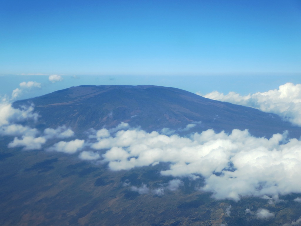
On the older islands of Ndzuwani and Mwali, weathered volcanic peaks and steep valleys hold surface streams and waterfalls, though clearing trees on steep slopes has dried many streams and increased soil erosion. Across all three islands, a short walk inland brings a sharp change in altitude, rain and road access. Coastal towns face the channel, while farming villages climb into the cooler hills. National life therefore crosses two kinds of distance: the open sea between islands and the steep climbs inside each one.[4][12]
Inter-island transport is a daily practical concern in an island republic. A World Bank maritime study describes how shallow ports, rough monsoon seas and scarce ferries raise shipping costs and slow travel. Its 2021 assessment noted that Mohéli depended heavily on small cargo boats at Fomboni and Hoani for rice, fuel, cement and hospital trips. Conditions change as ports are repaired, yet the sea lane remains the country’s main internal highway. Although the islands sit within sight of one another on clear days, ticket prices and boat safety determine how easily people and food cross the water.[15]
Mohéli shows how closely island livelihoods depend on healthy coasts. Designated by UNESCO in 2020, the Mwali Biosphere Reserve covers the whole island of Mohéli and its surrounding marine park. Its waters hold fringing coral reefs, rocky islets, lagoons, seagrass beds, mangroves and wooded streams. Green sea turtles nest on its beaches, humpback whales calve offshore, and dugongs feed in the seagrass meadows. Rather than fencing local people out, the reserve relies on village associations to co-manage fishing gears and marine zones so reef fisheries and community life can endure together.[10][16]

Everyday belonging in the Comoros cannot be captured by a single tongue or by state borders alone. Shikomor, or Comorian, is spoken across the islands in distinct local forms: Shingazidja on Grande Comore, Shindzuani on Anjouan and Shimwali on Mohéli, alongside Shimaore on Mayotte. Part of the Sabaki branch of Bantu languages and closely related to Swahili, Shikomor carries oral poetry, proverbs, town chronicles and home life. The constitution names Shikomor, French and Arabic as official languages. French is widely used in government offices, secondary schools, courts and business. Arabic is taught from early childhood in Quranic schools (palachioni) and anchors religious study and prayer.[2][11]
Sunni Islam of the Shafi‘i school shapes public and family life across the archipelago, alongside Sufi orders such as the Shadhiliyyah, Qadiriyyah and Rifa‘iyyah. It guides the calendar of feasts, early schooling, marriage customs and the mosques that stand at the heart of every town and village quarter. At the same time, matrilineal house inheritance and age-grade customs—especially on Ngazidja, where a family house (manyahuli) passes through daughters and wives—work alongside Islamic law. Comorian society grew out of centuries of African, Swahili, Arab, Malagasy and Indian Ocean contact rather than one single root.[4][6][8]
On Ngazidja in particular, the Anda or Grand Mariage—often called the “great marriage”—is a major customary institution. Part of an age-rank system, its multi-day public feasts, processions, dances, gold gifts and speeches grant a man full elder standing (wandrwadzima). That rank brings the right to speak in town councils and wear the ceremonial mharuma shawl. A World Bank study notes that while the custom strengthens village solidarity and diaspora ties, its high cost puts heavy savings pressure on families. Because customs take different forms on Ndzuwani and Mwali, the Grand Mariage is best understood as a powerful tradition rooted in specific island communities rather than a single rule for every Comorian.[8][12]
Everyday craft traditions carry these island heritages into public view. Women across the archipelago prepare and wear msindanu, an aromatic paste ground from sandalwood and coral stones applied in decorative geometric patterns across the cheeks and forehead to protect skin from the equatorial sun and mark celebratory occasions. Men wear embroidered velvet caps called kofia, patiently stitched by local artisans with delicate Quranic calligraphy or floral motifs that signal regional origin and social standing. In coastal markets, weavers turn dried raffia and palm fronds into durable mats and storage baskets used in spice curing. These everyday material arts are not commercial stage props; they are practical expressions of family care and community pride renewed through daily routine.[4][8][10]
The village and historic town quarter remain strong anchors of identity. World Bank urbanization research describes how village associations and elders organize local public works—paving streets, building classrooms, repairing mosques and digging water cisterns. Much of that work is funded by Comorian diaspora associations in France, especially in Marseille and Paris, as well as in Réunion and Madagascar. In local matters such as land boundaries and neighborhood peace, village councils and family elders often carry deeper trust than formal municipal offices.[12]
Food, farming and fishing show how island kitchens connect to wider markets. At home, cooks pair cassava, green bananas, breadfruit, taro and imported rice with coconut milk, reef or tuna fish, and local spices. A classic dish is mataba, made from pounded cassava leaves simmered slowly in thick coconut milk, while langouste à la vanille pairs local spiny lobster with cured vanilla pods. On export farms, distillers and growers produce ylang-ylang oil for perfumes alongside vanilla and cloves. Even so, the World Bank’s 2025 economic report notes that this narrow export base leaves the country reliant on imported rice, food and fuel. Strengthening local fishing fleets and marine conservation is a central goal of recent blue-economy plans. Meanwhile, remittances from the diaspora—which also played a historic role in independence organizing through movements such as MOLINACO—help families pay for food, schooling, house building and village projects.[10][12][13][14][16]
The Comoros is small in land area, yet its social and historical ties reach across the western Indian Ocean. Its story runs through monsoon dhow trade, walled sultanate medinas, colonial plantations and global migration. Its present is shaped by Karthala’s lava slopes, inter-island boats, local customs and the unresolved dispute over Mayotte. Mohéli’s marine reserves, Moroni’s stone alleys and Anjouan’s steep valleys all belong to one national portrait without becoming identical scenes.[1][8][10]
To meet the Comoros is to see the ocean as both barrier and bridge. The historic medinas of Ngazidja and Ndzuwani hold the memory of port towns built through sea trade, local rule and Islamic learning. Beyond those old coral walls, boats, remittances and family visits still bind the islands to one another and to distant ports, even when sea crossings are rough and the political map stays unsettled. The Comoros comes into focus not as a remote scatter of volcanic peaks, but as a society built across water.[8][15]
For decades, paleontologists believed that coelacanths—an ancient lineage of lobe-finned fish with paired fins resembling early tetrapod limbs—had perished during the Cretaceous-Paleogene extinction event 66 million years ago. In 1938 and more extensively in 1952, living specimens were captured in deep waters off the volcanic slopes of the Comoros archipelago. Known locally as gombessa, these nocturnal, deep-sea predators inhabit submarine lava caves between two hundred and four hundred metres depth. Their survival earned them the title of living fossils, providing evolutionary insights into the vertebrate transition from water to land.
The volcanic island of Anjouan provides ideal subtropical conditions—rich basalt soils, high humidity, and oceanic breezes—for cultivating Cananga odorata, the ylang-ylang tree. Farmers prune the trees into low, spreading shrubs to facilitate manual harvesting. Every morning, workers pick mature yellow star-shaped flowers and transport them to copper wood-fired distilleries. The resulting essential oil possesses a heady, sweet floral aroma that serves as a cornerstone base note in French haute perfumery, including Chanel No. 5. Comoros produces the majority of the global commercial supply of ylang-ylang essence.
On Grande Comore, social prestige and political influence are achieved through the Anda, or Grand Marriage. Far more than a private wedding, the event is a lavish, multi-day village festival that requires the groom to distribute gold jewelry, cattle, and banquets to community elders and clan members. Fulfilling this costly obligation can take decades of personal savings. Upon completing the Grand Marriage, a man attains the revered status of Mdrumdzima, or “Complete Man,” earning the privilege to wear the embroidered ceremonial sash, sit on the village council, and speak at public assemblies.
During the 1974 independence referendum, three islands of the archipelago—Grande Comore, Anjouan, and Mohéli—voted to break colonial ties with France and declare sovereign independence. However, the fourth island, Mayotte, voted decisively to retain political integration with the French Republic. While the independent state claims Mayotte as sovereign national territory under international law, Mayotte voted in 2009 to become an overseas department of France. This political division created an international maritime border between neighboring islands, driving persistent migration in small wooden boats called kwassa-kwassa.
Last fact review: 2026-11-08 · Sources checked manually; facts are not automatically updated.
Explore the first-order regions in this GeoNames snapshot. Local names and levels vary.



We are building an open, source-backed atlas of every country, region, ocean and culture — combining verified geographic data with long-form cultural storytelling.
Names and immediate parent assignments: GeoNames, CC BY 4.0, 28 October 2026. Unspecified code 00 excluded. This is not an exhaustive list of districts, counties or municipalities. Photographs are credited individually beneath each image; one pictured place does not represent every landscape in its region.
Spotted a factual issue, a wrong location or a missing image credit? Tell us what needs checking.
Country collection: 193 UN members and 2 observer states. Geographic groups: UN M49. Administrative data: GeoNames (CC BY 4.0). Flag artwork: flag-icons (MIT). Snapshot: 28 October 2026.
Cultural journeys, craft traditions, and heritage chronicles from around the world.
In a photograph made in 2025, a water measurer in Ben Aissa holds a copper plate above the channel.…
A climber’s pierced boot soles lead into Bemaraha’s cave-cut limestone, its small wildlife habitats and the human histories associated…
After the Second World War, William Barclay asked the Red Cross and Allied agencies tracing looted property to help…
Alfred Maudslay found the carved stone already fallen. His diary entry for 19 March 1882 records the lintel at…





Share what you know
Been there, grew up there, or know something we missed? Add a comment; corrections with a source are especially welcome.