







Occupying the continental crossroads where South Asia meets Southeast Asia, the Republic of the Union of Myanmar (Burma) is the largest country in mainland Southeast Asia, covering 676,578 square kilometers. Shaped like a vast amphitheater, the nation is girdled on three sides by formidable mountain ramparts—the Arakan Mountains (Rakhine Yoma) to the west along the borders with Bangladesh and India, the glaciated eastern Himalayas to the north adjoining China, and the limestone Shan Plateau and Tenasserim hills to the east bordering Laos and Thailand—while opening southward to the Bay of Bengal and the Andaman Sea across nearly two thousand kilometers of coast [2]. Down the central depression flows the life-giving Ayeyarwady (Irrawaddy) River, whose fertile floodplains and alluvial delta have nourished urban civilizations, royal capitals, and agricultural kingdoms for more than two millennia [6]. Grounded in Theravada Buddhism, indigenous spirit veneration (*nat* worship), and multiethnic cultural traditions, Myanmar encompasses a landscape of deep spiritual and architectural devotion [1].
The Central River Axis and Mountain Ramparts
Myanmar’s physical geography is structured by three major river corridors that flow from north to south, carved between parallel tectonic mountain belts formed during the collision of the Indian and Eurasian tectonic plates. The central spine is the Ayeyarwady River, which originates at the confluence of the N’Mai and Mali rivers in the northern mountains of Kachin State. Flowing for 2,288 kilometers, the Ayeyarwady is the economic and cultural lifeline of the nation, navigable by river steamers for over one thousand kilometers and dividing into a vast nine-armed delta covering thirty-five thousand square kilometers that produces the majority of the nation’s rice harvest.
In the far north, where the Himalayan chain bends into the Hengduan Mountains, lies Hkakabo Razi. Rising to 5,881 meters on the border with China, it is the highest peak in Southeast Asia, crowned with permanent glaciers and surrounded by subalpine rhododendron forests and dense temperate rainforests inhabited by red pandas and takin. Parallel to the Ayeyarwady to the east runs the Salween (Thanlwin) River, an untamed, largely dam-free river that roars through deep limestone gorges across the Shan Plateau, and the Sittaung River, flowing through a fertile trough between the Pegu Yoma and the eastern highlands.
The climate is governed by the Southwest Monsoon, which delivers torrential rainfall between May and October to the coastal regions of Rakhine and Tanintharyi (often exceeding 5,000 millimeters annually). However, as rain clouds pass over the Arakan Mountains, they deposit their moisture, creating a pronounced rain shadow across central Myanmar known as the Dry Zone (Anya). Receiving less than 750 millimeters of rain per year, the Dry Zone features semi-arid scrub, tamarind and toddy palms, and cactus hedges, yet served historically as the agricultural and political heartland of early Burmese dynasties, whose engineers mastered complex tank and canal irrigation systems [6].
Bagan: The Monumental Temple Plain of the Ayeyarwady
On a dramatic bend of the Ayeyarwady River within the Dry Zone lies Bagan, one of the supreme architectural and religious achievements of the ancient world. Between the ninth and thirteenth centuries, Bagan served as the capital of the Pagan Kingdom, the first kingdom to unify the disparate regions of modern Myanmar under centralized rule and establish Theravada Buddhism as the state religion [1].
Across an arid alluvial plain covering 104 square kilometers, devout monarchs, queens, monks, and wealthy ministers constructed more than ten thousand Buddhist monuments as acts of spiritual merit-making (kuthol). Today, over three thousand five hundred brick temples, stupas (pagodas), monasteries, and ordination halls survive, creating an astonishing forest of terracotta and gilded spires rising above acacia trees and sandy paths [1]. Inscribed on the UNESCO World Heritage list in 2019, Bagan illustrates the evolution of Buddhist sacred architecture from early Indian and Pyu prototypes to mature Burmese classical forms.
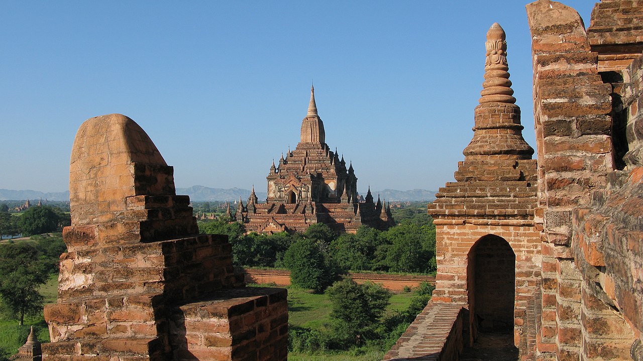
Bagan’s monuments divide into two primary structural forms: solid stupas (zedi), such as the bell-shaped Shwezigon Pagoda with its terrace-mounted terracotta plaques illustrating the Jataka tales of the Buddha’s previous lives, and hollow temples (gu), designed for meditation and circumambulation around monumental Buddha images. The Ananda Temple, consecrated in 1105 under King Kyansittha, represents the masterpiece of Bagan architecture, featuring a Greek-cross plan with four soaring thirty-foot standing Buddhas facing the cardinal directions, illuminated by concealed skylights that bathe the gilded faces in radiant sunlight. Later colossal temples, including Dhammayangyi (famed for its mortarless brickwork of miraculous precision) and Htilominlo, demonstrate the advanced structural brick vaulting, pointed arches, and glazed ceramic decorative tiles engineered by Bagan master masons before the kingdom’s political decline in the late thirteenth century [1].
Bagan was preceded by the Pyu Ancient Cities—Halin, Beikthano, and Sri Ksetra—inscribed by UNESCO in 2014 as Myanmar’s first World Heritage site [3]. Flourishing between 200 BCE and 900 CE, these massive brick-walled cities featured monumental cylindrical stupas, sophisticated hydraulic canals, and funerary urns inscribed in the Pyu script, evidencing early maritime cultural exchanges with India that introduced Buddhist scriptures and Sanskrit cosmological models to the Ayeyarwady basin.
Inle Lake: The Aquatic Kingdom of the Intha
High in the limestone hills of Shan State, at an elevation of nearly nine hundred meters above sea level, lies Inle Lake. Covering an area of approximately 116 square kilometers, this shallow freshwater highland lake is surrounded by mist-shrouded limestone karsts and inhabited primarily by the Intha (“sons of the lake”), an ethnic community who have engineered a distinctive amphibious civilization completely adapted to wetland life.

Intha men are renowned worldwide for their distinctive one-legged rowing style. Standing upright on the flat stern of slender wooden dugout canoes, a fisherman wraps one leg around a single long wooden oar, pivoting his hip to propel and steer the boat through dense beds of submerged reeds and water hyacinths. This stance elevates the rower’s eye level above the tangled water weeds, allowing him to spot movements of fish beneath the surface while keeping both hands completely free to handle large conical bamboo-and-net fishing traps (saung).
The Intha have expanded their living space across the water by constructing entire villages on wooden stilts, complete with floating schools, monasteries, and market canals. In shallow bays, they created *floating gardens* (ye-chan), ingenious artificial agricultural islands constructed by gathering thick mats of naturally buoyant marsh weeds (mainly *Eichhornia crassipes*), cutting them into long strips, anchoring them to the lakebed with long bamboo poles, and topping them with nutrient-rich silt dredged from the lake floor. On these floating hydroponic plots, farmers produce abundant harvests of tomatoes, cucumbers, eggplants, and chilies that supply markets across central Myanmar.
Inle Lake is also the sole birthplace of lotus silk weaving, one of the rarest textile arts in the world. In stilt workshops in the village of Inpawkhon, women harvest long stems of the sacred lotus flower (*Nelumbo nucifera*), snapping the stems and deftly pulling out dozens of microscopic sap filaments, twisting them together on wet wooden tables to spin fine yarn. Woven on traditional wooden handlooms, lotus fabric requires tens of thousands of lotus stems to produce a single monk’s robe or ceremonial scarf, creating a breathable, naturally waterproof fabric prized for its spiritual purity.
Shwedagon Pagoda: Spiritual Radiance of Yangon
In the southern port city of Yangon (formerly Rangoon), rising above Singuttara Hill, stands the Shwedagon Pagoda (Great Dagon Pagoda), the most sacred and revered Buddhist sanctuary in Myanmar. According to sacred chronicles (*Thathana-win*), the pagoda’s origin dates back more than 2,500 years to the lifetime of Gautama Buddha, when two merchant brothers from Mon country, Tapussa and Bhallika, were gifted eight sacred hairs of the Buddha’s head. Guided by spirits to Singuttara Hill, where relics of three previous Buddhas were already enshrined, the King of Okkalapa established a golden pagoda to house the sacred hairs.

Successive Burmese and Mon sovereigns rebuilt and enlarged the monument over centuries, culminating under Queen Shin Sawbu (who reigned in the fifteenth century) and King Dhammazedi, who donated her own weight in gold to plate the stupa. Today, the main golden stupa rises ninety-nine meters above the marble terrace, plated with genuine gold plates donated by millions of pilgrims and topped with a seven-tiered umbrella crown (*hti*) adorned with thousands of gold and silver bells that chime in the coastal breeze. At the pinnacle sits a diamond-encrusted orb (*seinbu*) topped by a single seventy-six-carat diamond that catches the last rays of sunset.
Surrounding the main stupa is an expansive marble courtyard containing sixty-four smaller stupas and devotional pavilions dedicated to the eight planetary posts corresponding to the days of the week in the traditional Burmese astrological calendar (with Wednesday divided into morning and evening). Pilgrims gather at their birth-day shrine—whether governed by the garuda, tiger, lion, tusked elephant, or dragon—to pour water over the Buddha image and offer fragrant jasmine garlands, lighting thousands of clay oil lamps as darkness falls across the city.
Multiethnic Fabric, Ayeyarwady Dolphins, and Daily Life
Myanmar is an intricate multiethnic confederation comprising one hundred and thirty-five officially recognized national races, divided into eight major ethnic nationalities: the majority Bamar (who constitute roughly two-thirds of the population and dominate the central plains), the Shan of the eastern plateaus, the Karen (Kayin) of the southern mountains and delta, the Rakhine along the western coast, the Kachin of the northern highlands, the Chin of the western hills, and the Mon and Kayah. Managing ethnic federalism, regional autonomy, and social peace has remained the defining political challenge of Myanmar’s modern history since gaining independence from British colonial rule in 1948 [6].
Along a four-hundred-kilometer stretch of the upper Ayeyarwady River between Mandalay and Bhamo, a remarkable ecological partnership has existed for generations between artisanal fishermen and wild Ayeyarwady dolphins (*Orcaella brevirostris*). In this cooperative fishing tradition, fishermen communicate with dolphins by tapping wooden pegs on their canoe gunwales and mimicking bird calls; the dolphins respond by rounding up schools of fish into tight pockets toward the boats, using their tail flukes to slap the surface and signal when fishermen should cast their circular handheld throw-nets. The dolphins feast on the scattered fish that escape the nets, exemplifying a rare mutualistic partnership between humans and wild cetaceans that conservation groups and national park authorities are working to protect from illegal electric fishing and gold mining pollution.
Near the royal capital of Mandalay, the country’s ancient relationship with precious timber is preserved at the U Bein Bridge in Amarapura. Spanning 1.2 kilometers across the shallow waters of Taungthaman Lake, U Bein is the oldest and longest teakwood bridge in the world. Constructed around 1851 under the Konbaung dynasty using more than one thousand reclaimed teak pillars salvaged from the deserted royal palace of Inwa, the curved footbridge continues to serve hundreds of monks, saffron-robed novices, and local farmers walking between monasteries and market villages at sunrise and dusk.
Everyday life in Myanmar is unified by deeply cherished cultural practices. Most visibly, women, children, and many men apply *thanaka* to their faces—a fragrant, yellowish-white cosmetic paste produced by grinding the bark of the wild wood-apple tree (*Murraya paniculata*) on a circular stone slab (*kyauk pyin*) with a few drops of water. Applied in circular patches or elegant leaf patterns, thanaka acts as a natural sunscreen, cooling skin ointment, and aromatic adornment worn across towns and villages. Men and women alike wear the *longyi*, a cylindrical tubular wrap sewn from handwoven cotton or silk, tied in a knot at the waist.
The culinary morning ritual across Myanmar centers on *mohinga*, the undisputed national dish. Prepared from thin rice noodles submerged in a rich, comforting broth of pounded catfish simmered with lemongrass, ginger, garlic, toasted chickpea flour, and tender banana-stem slices, mohinga is garnished with crispy split-pea fritters, hard-boiled eggs, fresh coriander, and a squeeze of lime. In rustic tea shops that serve as communal centers for social life, locals gather over sweet milk tea (*laphet-yay*) and savory samosas to discuss news, literature, and monastery affairs, reflecting a resilient cultural warmth that endures through every trial.
Resource Wealth and Modern Challenges
Myanmar is endowed with abundant natural wealth, including the world’s finest deposits of imperial jadeite in the northern mountains of Hpakant in Kachin State, world-famous pigeon’s blood rubies from Mogok in Mandalay Region, vast offshore natural gas reserves in the Yadana and Shwe fields, and extensive virgin teak (*Tectona grandis*) forests [5]. However, the governance of these high-value natural resources has historically driven regional conflict and environmental degradation, underscoring the urgent necessity for transparent resource revenue sharing and democratic accountability [4].
Following decades of military rule, a brief period of political and economic opening in the 2010s saw rapid expansion in telecommunications, light manufacturing, and international cultural engagement. However, political instability and renewed domestic conflict since 2021 have placed severe strain on the country’s economy, human development, and infrastructure [4]. Amidst these formidable challenges, the people of Myanmar remain deeply grounded in their Buddhist values of generosity (dana), communal solidarity, and deep reverence for the sacred landscape. From the ancient stupas of Bagan mirrored in the Ayeyarwady to the peaceful waters of Inle Lake, Myanmar preserves an indelible spiritual soul that continues to inspire the global imagination.








Share what you know
Been there, grew up there, or know something we missed? Add a comment; corrections with a source are especially welcome.