




Positioned at the southeastern shoulder of the Arabian Peninsula, the Sultanate of Oman guards the maritime gateway between the Persian Gulf and the open shipping lanes of the Indian Ocean. Bordered by the United Arab Emirates to the northwest, Saudi Arabia across the hyper-arid sands of the Rub’ al Khali to the west, and Yemen to the southwest, the country stretches along 3,165 kilometers of coastline facing the Gulf of Oman and the Arabian Sea. Across 309,500 square kilometers, Oman has maintained an independent civilization rooted in maritime trade, ancient oasis irrigation, Ibadi Islamic consensus, and mountain geography that long resisted foreign domination.
Unlike many of its Arabian neighbors whose territories consist largely of flat desert sand, Oman is anchored by the dramatic mountain spine of the Al Hajar range, which rises to over three thousand meters and traps seasonal rainfall that feeds subterranean aquifers. In the far north, the exclave of Musandam thrusts into the Strait of Hormuz, where drowned limestone valleys—often called the ‘Fjords of Arabia’—command the world’s most critical oil transit chokepoint. In the far south, the province of Dhofar catches the summer Indian Ocean monsoon, transforming parched limestone plateaus into emerald pastures where ancient frankincense trees produce aromatic resin prized since antiquity.
The Hajar Mountains and the Ophiolite Obduction
The northern interior of Oman is dominated by the Al Hajar Mountains, an imposing limestone and ophiolite chain that sweeps in an arc for nearly seven hundred kilometers from the Musandam Peninsula to Sur on the eastern seaboard. Geologists consider Oman the world’s premier natural laboratory for oceanic crustal studies because of the Semail Ophiolite, a colossal slab of ancient oceanic lithosphere and upper mantle that was thrust over continental crust—a process known as obduction—roughly eighty million years ago during the Late Cretaceous epoch.
At the center of this mountain arc stands the Jebel Akhdar (‘Green Mountain’) massif and Jebel Shams (‘Mountain of the Sun’), which at 3,009 meters forms the highest summit on the Arabian Peninsula. Carved into the northern flank of Jebel Shams is Wadi Ghul, a dramatic limestone chasm plunging more than one thousand meters sheer to the gravel bed below, widely referred to as the Grand Canyon of Arabia. On the terraced limestone shelves of Jebel Akhdar, between two thousand and 2,500 meters above sea level, temperate microclimates allow farmers to cultivate pomegranates, walnuts, apricots, and the renowned Damask roses that are steam-distilled into fragrant rosewater in mountain villages like Saiq and Al Ayn.
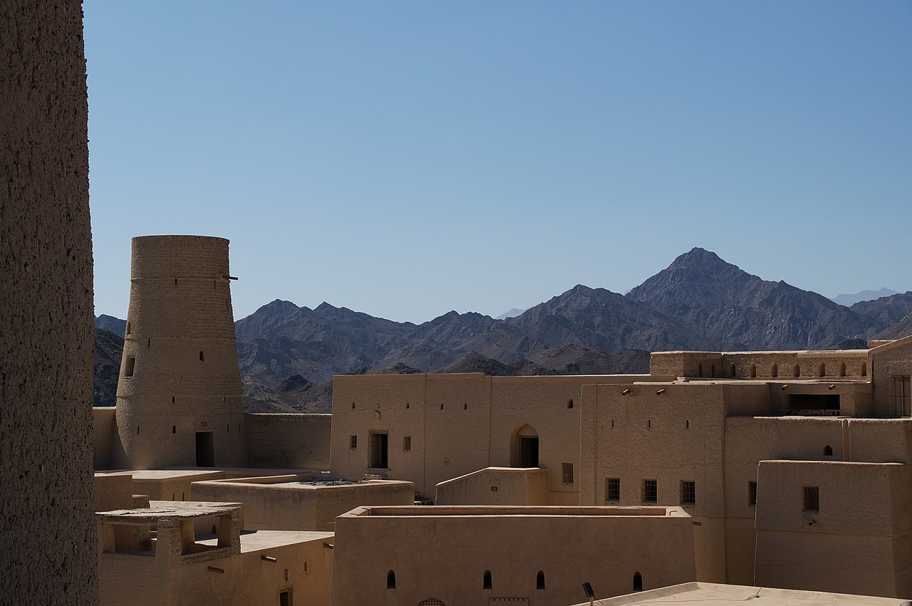
At the southwestern foot of the Jebel Akhdar sits Bahla, an ancient oasis town renowned as a center of traditional pottery and desert fortification. Dominating the town is Bahla Fort, inscribed on the UNESCO World Heritage List in 1987. Constructed of unbaked mud brick, straw, and stone foundations by the Banu Nebhan dynasty between the twelfth and fifteenth centuries, the fortress features massive rounded bastions, crenellated ramparts, and an internal maze of audience chambers, granaries, and secret escape wells. A twelve-kilometer earthen circuit wall (the Sur of Bahla) historically enclosed the entire oasis settlement, protecting date palm groves and falaj channels against nomadic raiders.
Nearby Nizwa, historically known as the ‘Pearl of Islam,’ served for centuries as the political and theological capital of the Ibadi imamate. The historic Nizwa Fort, completed in the 1650s by Imam Sultan bin Saif Al Ya’rubi, is distinguished by its monumental thirty-meter-high circular gun tower. Engineered to absorb artillery fire, the tower’s interior is fitted with deadly defensive traps, including pit openings above doorways where defenders poured boiling date syrup onto attacking forces.
Aflaj Engineering and Oasis Agriculture
Human settlement across the arid interior of Oman has been sustained for millennia by one of the most sophisticated hydraulic systems in the ancient world: the aflaj (singular falaj). Dating back to at least 2500 BCE, this gravity-driven water distribution network taps into subterranean water tables at the base of the mountains, guiding water through gently sloping tunnels and surface stone aqueducts across tens of kilometers to desert oases without the use of mechanical pumps.
In 2006, UNESCO inscribed five representative systems as the Aflaj Irrigation Systems of Oman on the World Heritage List, including Falaj Daris in Nizwa and Falaj Al Khatmeen in Birkat Al Mouz. The aflaj operate according to three structural typologies: Dawoodi (deep underground channels fed by mother wells in mountain alluvial fans), Ghaili (surface channels capturing seasonal runoff from wadi gravel beds), and Ayni (channels directly tapping natural mineral and thermal springs).
Beyond engineering, the falaj embodies an egalitarian community governance structure developed under Ibadi legal jurisprudence. Water shares are measured using sundials during daylight hours and stellar observations by night, ensuring that every farmer receives water allocations proportionate to land holdings. Water flows first to drinking cisterns, then to mosque ablution pools, domestic washing basins, and public bathhouses, before flowing out to irrigate date palm orchards, lime groves, and alfalfa fodder fields. This communal discipline fostered social cohesion and agricultural resilience across hyper-arid landscapes.
Wahiba Sands and Bedouin Desert Landscapes
South and east of the Hajar Mountains, the gravel plains yield to the Wahiba Sands (also known as the Sharqiya Sands), an immense sea of sand covering approximately ten thousand square kilometers. Stretching 180 kilometers north to south and eighty kilometers east to west, the Wahiba Sands are characterized by towering longitudinal dunes that rise over one hundred meters, aligned along a south-southwest to north-northeast axis dictated by seasonal monsoon wind patterns.

The sands exhibit remarkable chromatic variation, shifting from pale honey and golden yellow in the north to deep coppery red in the south, reflecting differing mineral concentrations of iron oxide and quartz. Despite extreme aridity, the Wahiba ecosystem supports diverse wildlife adapted to desert conditions, including the Arabian sand gazelle (Gazella marica), sand cats, desert hedgehogs, and more than one hundred species of birds. Native desert trees, such as the Ghaf (Prosopis cineraria) and desert acacia, survive by sending taproots dozens of meters down to reach deep moisture reserves.
The Wahiba Sands are the ancestral territory of Bedouin pastoral tribes, notably the Al Wahiba and Janaba. For centuries, Bedouin camel herders navigated these dunes using stellar navigation, moving between winter desert pastures and summer date harvests in coastal oases. Today, Bedouin families maintain dromedary camel breeding, racing traditions, and goat pastoralism, hosting travelers in goat-hair tents while maintaining deep knowledge of desert tracks and subterranean water soaks.
Dhofar and the Frankincense Coast
In southern Oman, more than eight hundred kilometers from Muscat, lies the province of Dhofar, which presents an ecological environment entirely distinct from the rest of the Arabian Peninsula. Between late June and early September, the southwest Indian Ocean monsoon—locally termed the Khareef—blankets the coastal plains around Salalah and the seaward escarpments of the Jebel Qara and Jebel Samhan in dense fog, drizzle, and cloud cover. During this season, temperatures hover around twenty-five degrees Celsius while waterfalls tumble down limestone cliffs and dry mountain slopes turn into lush green pastures where Dhofari pastoralists herd humped cattle.
Dhofar is the historic cradle of the frankincense trade, inscribed by UNESCO as the Land of Frankincense World Heritage site. On the semi-arid northern slopes of the Dhofar mountains—in places like Wadi Dawkah, where maritime monsoon mists yield to dry desert heat—grows Boswellia sacra, the frankincense tree. Local harvesters make shallow incisions (tawqee) into the bark using a chisel-like knife called a minghaf, allowing milky sap to exude and harden into aromatic crystalline tears. The finest grade, known as Hojari, is harvested during the dry autumn months and is celebrated for its pale amber clarity and citrus-pine fragrance.
For more than three thousand years, frankincense was one of the most valuable commodities in global commerce, burned in pharaonic temples in Egypt, imperial Roman ceremonies, and Chinese imperial courts. Caravans departed from the fortified desert staging post of Shisr (associated with the legendary lost city of Ubar), crossing the Rub’ al Khali toward Petra and the Mediterranean. Simultaneously, merchant dhows loaded frankincense at the ancient port of Sumhuram (Khor Rori) and the medieval coastal hub of Al Baleed, sailing across the Indian Ocean on the prevailing seasonal winds.
The Maritime Empire and Muscat’s Renaissance
Oman’s maritime heritage is among the oldest in the world. As early as the third millennium BCE, the ancient Sumerians traded with the seafaring civilization of Magan (located in modern Oman), importing copper ingots smelted from Hajar mountain ores. By the ninth century CE, Omani navigator Abu Ubaida Abdullah bin al-Qasim made the epic voyage from Sohar to Canton (Guangzhou) in China aboard a hand-sewn wooden dhow, inspiring the literary legend of Sinbad the Sailor.
In the seventeenth century, under the Ya’rubi dynasty, Oman expelled Portuguese colonial garrisons from Muscat and built a formidable oceanic navy. By the early nineteenth century, during the reign of Sayyid Said bin Sultan (1804–1856), the Sultanate of Muscat and Oman ruled a trans-oceanic maritime empire extending from the Persian Gulf to Mogadishu, Mombasa, and Zanzibar. Sayyid Said moved his royal court to Zanzibar in 1840, turning the East African island into a global center for clove cultivation and Indian Ocean commerce, linking Omani merchant families across continents.

Following a period of economic decline in the late nineteenth and early twentieth centuries, Oman experienced an extraordinary modern transformation known as the Blessed Renaissance, initiated in July 1970 when Sultan Qaboos bin Said Al Said ascended the throne. Utilizing revenues from commercial oil exports discovered at Yibal in 1964, Sultan Qaboos rapidly modernized national infrastructure, building thousands of kilometers of highways, modern hospitals, universities, and international seaports while strictly preserving traditional architectural aesthetics.
Nowhere is this architectural philosophy more evident than in Muscat, the national capital. Unlike the glittering glass skyscrapers of Dubai or Doha, Muscat strictly regulates building heights and mandates traditional Arabian and Islamic design elements, including whitewashed facades, arched windows, and decorative crenellations. The spiritual summit of this vision is the Sultan Qaboos Grand Mosque, inaugurated in 2001 to commemorate thirty years of the Sultan’s reign. Built from three hundred thousand tonnes of Indian sandstone, its central prayer hall can accommodate twenty thousand worshippers, crowned by a fifty-meter dome and illuminated by an eight-tonne chandelier adorned with Swarovski crystals. The floor is covered by a 4,300-square-meter hand-knotted Persian carpet produced by six hundred weavers over four years in Khorasan.
Ibadi Philosophy, Tolerance, and Diplomacy
The cultural and political character of Oman is shaped by Ibadism, a moderate and distinct branch of Islam that predates both mainstream Sunni and Shia traditions. Arriving in Oman in the seventh century, Ibadi theology emphasizes rigorous ethical conduct, individual piety, communal consultation (shura), and the rejection of dynastic succession in favor of elected religious leadership (the Imamate). Unlike the historical rigidity of early Kharijite factions from which it diverged, Omani Ibadism evolved into a deeply tolerant tradition that prioritizes non-violence, coexistence, and respect for other faiths.
This religious moderation underpins Oman’s long-standing foreign policy of positive neutrality and quiet diplomacy. Known as the ‘Switzerland of the Middle East,’ the Sultanate maintains cordial diplomatic relations with all regional and global powers, including Iran, Saudi Arabia, the United States, and Western European nations. Muscat has repeatedly served as a trusted mediator for international peace negotiations, facilitating back-channel talks that produced the 2015 Joint Comprehensive Plan of Action (JCPOA) Iranian nuclear agreement, as well as hostage releases and diplomatic reconciliations across the Gulf.
Economic Vision 2040 and Green Horizons
While petroleum exports have fueled Oman’s modernization over the past half-century, the nation possesses smaller hydrocarbon reserves than its neighbors in the Gulf Cooperation Council (GCC). In response, the government has enacted Oman Vision 2040, a comprehensive strategic blueprint spearheaded by Sultan Haitham bin Tariq to transition the economy toward a sustainable, diversified post-oil future.
Economic diversification focuses on logistics, mining, fisheries, advanced manufacturing, and high-value cultural and eco-tourism. The expansion of deepwater ports at Duqm, Sohar, and Salalah leverages Oman’s geographic position outside the Strait of Hormuz, offering maritime carriers direct access to Indian Ocean shipping corridors without navigating crowded Gulf waters. The Special Economic Zone at Duqm (SEZAD) is developing into a major industrial and petrochemical hub, incorporating one of the Middle East’s largest ship repair drydocks.
Furthermore, Oman has committed to becoming a leading global exporter of green hydrogen and renewable energy by 2030. Harnessing the country’s exceptional solar irradiance in the interior deserts and consistent wind regimes along the southern Arabian Sea coast, the Sultanate has allocated tens of thousands of square kilometers of public land for utility-scale solar and wind generation, powering electrolyzers to produce zero-carbon green hydrogen and green ammonia for export to European and Asian industrial markets.
The Sultanate of Oman endures as a proud bastion of Arabian authenticity and maritime dignity, where ancient watercourses still nourish mountain terraces, where the aroma of burning frankincense mingles with the sea breeze of Muscat harbor, and where enduring wisdom guides a peaceful nation toward a sustainable future.








Share what you know
Been there, grew up there, or know something we missed? Add a comment; corrections with a source are especially welcome.