Spain connects a high interior plateau to Atlantic, Cantabrian and Mediterranean shores through regions with distinct languages, histories and everyday lives.
Neighbours from Wikidata (land borders and some sea borders; only places with a page here).
FLAG & SYMBOLS
The flag and symbols of Spain
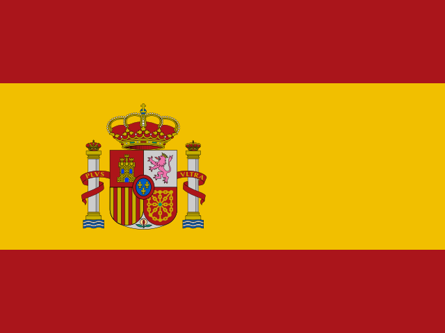
The flag
Three horizontal bands of red (top), yellow (double-width), and red, with the national coat of arms on the left side of the yellow band; the coat of arms shows the emblems of the area's former kingdoms (clockwise from upper left: Castile, Leon, Navarre, and Aragon), which also used red and yellow as their colors; the stylized pomegranate at the bottom of the shield represents Granada; the two columns represent the Pillars of Hercules, which are promontories (Gibraltar and Ceuta) on the Strait of Gibraltar; a red scroll bears the imperial motto of "Plus Ultra" (further beyond), referring to Spanish lands outside Europe.
"Himno Nacional Espanol" (National Anthem of Spain) no lyrics/unknown
National day
National Day (Hispanic Day), 12 October (1492)
Independence
1492
Flag description and meaning, colours, symbols, anthem details, national day and independence: CIA World Factbook (public domain). Coat of arms, motto and recording: Wikidata and Wikimedia Commons (credited above). Flag artwork: flag-icons (MIT), retrieved 1 November 2026.
UNESCO WORLD HERITAGE
49 World Heritage Sites in Spain
41 Cultural4 Natural2 Mixed4 shared with other countriesFirst listed 1984 · latest 2023
Sites, years and types: the UNESCO World Heritage List via Wikidata, retrieved 1 November 2026; ordered by year listed. Names link to English Wikipedia, or to the UNESCO page when there is no article.
The Landlore · 1614 words · 8 min read · Reviewed 2026-11-07
A tidal channel carries ships from the Atlantic to Seville, far inland along the Guadalquivir. That river route opens onto the larger shape of Spain: a high interior plateau, divided by mountain ranges and draining toward both the Atlantic and Mediterranean. The Tagus and Douro run west; the Ebro crosses the northeast, while the Guadalquivir connects Andalusia to the Atlantic. Spain’s watersheds give the country several directions at once, linking regions with different climates, languages and histories within one constitutional state.[20][1][2]
That shared state is younger than many of the places it governs. Its constitution recognises both the unity of the Spanish nation and the autonomy of the nationalities and regions within it. Seventeen autonomous communities and two autonomous cities form a political map that gives regional institutions a real part in public life. The arrangement shows why Spain feels different from one region to another, and why questions of language, memory and authority are part of ordinary national conversation.[3][4]
Language makes the map audible
Spanish, also called Castilian, is the official language of the state. Catalan, Galician, Basque and Aranese have official status in particular autonomous communities under their statutes. Valencian is the name used for the Valencian Community’s own official language. These languages appear in schools, local government, media, literature and daily conversation, though people’s choices and fluency vary. In borderlands and cities, language can change across a short journey; in many households, people move between more than one language in a day.[10]
The variety has deep roots. Basque is unrelated to the Romance languages that grew from Latin; Catalan and Galician developed through their own literary and regional histories. Spanish itself took shape from Castilian and expanded through state institutions, schooling, literature and, later, mass media. A shared national language supports communication across the country, while regional languages carry local memory and civic identity. Their legal status reflects political agreements as well as cultural continuity.[10]
Language also crosses the country’s borders. The Spanish spoken in Madrid, Seville, Mexico City and Buenos Aires shares a broad linguistic inheritance while carrying different accents and vocabularies. Migration has added further languages to Spanish neighbourhoods and schools, and many residents maintain family ties across continents. Children in bilingual communities may learn the state language and a regional language through school, while adults use different languages at work, at home or with public services. The result is a country whose public language map is both regional and international.
Work and movement across regions
Regional economies in Spain differ sharply. ICT and financial services are concentrated in Madrid and Barcelona, while many coastal and island regions rely more heavily on tourism; industrial activity and innovation also cluster in selected regions. These patterns shape work and investment, but each region includes different rural and urban livelihoods. People encounter the differences in the work available near home and in the services that grow around it.[5]
People move within Spain for work, education, housing and family, and migration from abroad has become a major part of recent population growth. The National Statistics Institute records strong net migration from outside Spain. Madrid, Barcelona and Valencia drew the most new residents from abroad, even as each recorded net out-migration to other Spanish municipalities. These intersecting flows reshape workplaces, classrooms and neighbourhoods, while residents’ experiences differ with legal status, income and access to services. A national picture includes both long-established communities and people who have made Spain home more recently.[11][12]
Autonomy is also encountered through public services. Regional governments administer health, education and social services, within a system where responsibilities are divided and shared with the central state. They also coordinate with municipalities, which manage many of the services closest to residents, from local roads to waste collection and public spaces. Schools reflect this arrangement in curricula and language policy, while regional health administrations organise services close to where people live. In bilingual communities, pupils may study in Castilian and a co-official language such as Catalan, Galician or Basque, making the constitutional language framework part of school life.[10] The structure gives local institutions a direct role in everyday life. Residents encounter it in school administration, regional health services and local infrastructure, while shared responsibilities make coordination and funding a recurring public concern.[3][17]
Food, music and the work of keeping traditions alive
Food in Spain follows landscapes and work. Olive groves and vegetable production are central to agriculture in Andalusia, where hillside and valley estates supply olive oil to domestic kitchens and export markets; rice cultivation is closely associated with the wetlands and irrigated fields of Valencia, and livestock and cereals shape the interior plateaus. Galician Rías Baixas and northern Atlantic ports bring shellfish and fish to regional markets, while cured meats and sheep and goat cheeses from inland regions reflect pastoral traditions across the Meseta and mountain valleys. Migration and travel keep changing what people grow, cook and eat.[13][19][21]
UNESCO’s Mediterranean diet recognition describes shared practices around growing, preparing and eating food, including knowledge of agriculture and fishing, ways of cooking and the social time of meals. It is a cultural framework, not a portrait of every person’s daily diet. The same ingredients can mean different things in a household, a workplace lunch or a public celebration; price, season and available time matter as much as heritage.[13]
Flamenco offers a different example of a living tradition with a particular home and a wider reach. Andalusia is its heartland, while its forms have roots and histories in neighbouring regions and have travelled with performers and audiences. On La Gomera in the Canary Islands, the whistled language Silbo Gomero carries another local language practice across the island’s ravines. Singing, guitar and dance are not a single fixed expression: artists continue to interpret the form, and communities debate how it is presented and taught. Its global recognition makes it a doorway into Andalusia, not a substitute for learning about the region’s other lives and sounds.[14]
Spain’s cultural life also includes religious processions, local music, contemporary design, literature, football and the everyday gathering places of towns and cities. The traditions that draw visitors are sustained by people who live with them: performers, cooks, farmers, volunteers, teachers, craftspeople and local institutions. What lasts is not simply an image for outsiders; it is knowledge and practice that people adapt, argue over and pass on.
Pilgrims gather on the stone paving of the Praza do Obradoiro before the Cathedral of Santiago de Compostela in Galicia. Photo: P.Lameiro / Wikimedia Commons · CC BY-SA 3.0
Where Seville’s river reaches the Atlantic
Spain is easiest to understand when you follow a route long enough for its terms to change. A train across the plateau gives way to another climate at the Atlantic edge; a road through the Ebro valley meets cities and farms shaped by its river; a ferry carries the country’s daily life onto an island. At each turn, language, architecture, work and food reveal older connections and newer arrivals. Spain’s regions are not chapters in a completed past but places where people make a shared present under a common constitutional frame.
Perched above the Darro river valley in Granada, the Nasrid palace complex of the Alhambra preserves the supreme refined pinnacle of Moorish architectural and garden design in Andalusia. Photo: Mgimelfarb / Wikimedia Commons · CC BY-SA 4.0
At Seville, the Guadalquivir carries an Atlantic route inland to a working port, where ships meet rail and road connections. Elsewhere, the Ebro reaches the Mediterranean and rivers from the northern ranges descend toward the Bay of Biscay. The country’s shores are not simply its edges: its rivers bring maritime trade into the interior and carry the contrasts between Spain’s regions back out to sea.[1][20]
Atlas Inquiry: key geographic and cultural questions
How did the era of Al-Andalus transform Iberian architecture, agriculture, and scholarship?
From the Muslim conquest in 711 until the fall of Granada in 1492, Islamic rule across southern Iberia established advanced irrigation networks, introducing crops like citrus, rice, sugar cane, and cotton. Cities like Córdoba became intellectual centers where scholars translated classical Greek, Persian, and Indian philosophy, medicine, and mathematics into Arabic and Latin. Architectural monuments such as the Alhambra and the Mezquita of Córdoba integrated geometric tilework, horseshoe arches, and stalactite vaulting, leaving an enduring aesthetic and linguistic footprint across Spanish culture and regional Romance dialects.
What makes the Basque language linguistically distinct from other European tongues?
Spoken in the Pyrenean borderlands between northeastern Spain and southwestern France, the Basque language (Euskara) is a true language isolate, possessing no genealogical relationship to Romance, Germanic, Celtic, or Slavic languages. Historical linguists determine that Basque represents a surviving pre-Indo-European linguistic stratum that predates the arrival of Indo-European speakers in Western Europe thousands of years ago. Basque features complex agglutinative morphology, ergative-absolutive alignment, and polypersonal verb agreements, making its preservation through centuries of Romanization and royal centralism an extraordinary feat of cultural resilience.
How does the topography of the central Meseta influence Spain’s regional climates?
The Meseta Central is a vast elevated plateau averaging six hundred to eight hundred meters in altitude, occupying nearly half of mainland Spain. Bordered by the Cantabrian Mountains to the north, the Iberian System to the east, and the Sierra Morena to the south, the plateau is shielded from moist Atlantic and Mediterranean maritime air masses. This continental exposure produces extreme temperature variations, featuring freezing winters, scorching summers, and sparse precipitation that shape dry-cereal farming in Castile and contrast sharply with the temperate, Atlantic landscapes of Galicia and Asturias.
Why has the pilgrimage route of the Camino de Santiago persisted for over a millennium?
Established in the ninth century following the claimed discovery of the tomb of the Apostle Saint James at Santiago de Compostela, the Camino de Santiago became one of medieval Christendom’s three major pilgrimage routes. Hundreds of thousands of pilgrims traversed diverse routes through France, northern Spain, and Portugal, spurring the construction of Romanesque bridges, hospitals, monasteries, and fortified towns along the path. Recognized as a UNESCO World Heritage cultural route, the Camino continues to draw walkers worldwide seeking spiritual contemplation, architectural exploration, and physical endurance across diverse landscapes.
We are building an open, source-backed atlas of every country, region, ocean and culture — combining verified geographic data with long-form cultural storytelling.
Names and immediate parent assignments: GeoNames, CC BY 4.0, 28 October 2026. Unspecified code 00 excluded. This is not an exhaustive list of districts, counties or municipalities. Photographs are credited individually beneath each image; one pictured place does not represent every landscape in its region.
We are building an open, source-backed atlas of every country, region, ocean and culture — combining verified geographic data with long-form cultural storytelling.












Share what you know
Been there, grew up there, or know something we missed? Add a comment; corrections with a source are especially welcome.