
Geomorphic Architecture and the Funneling Gulf
Hangzhou Bay represents one of the most hydrodynamically violent and morphologically dramatic macro-tidal estuaries on Earth. Indenting the eastern coastline of China between the mega-metropolises of Shanghai to the north and Ningbo to the south in northern Zhejiang province, this broad maritime funnel opens directly onto the shallow continental shelf of the East China Sea. At its seaward mouth between the Zhoushan Archipelago and Cape Nanhui, the bay spans approximately one hundred kilometers in width. Moving westward toward the freshwater gateway of the Qiantang River, the coastline contracts precipitously over a distance of roughly one hundred and twenty kilometers, tapering down to a narrow bottleneck barely twenty kilometers wide near Ganpu and fewer than two kilometers near Haining.
This extreme coastal convergence is matched by an equally dramatic upward slope of the submarine bathymetry. The outer bay exhibits depths averaging eight to twelve meters, dissected by dynamic tidal channels and shifting submarine shoals. However, as the waterway narrows, the seafloor abruptly shoals into an immense subaqueous sandbar, known historically as the ‘sand spit’ (Shagan). Formed by the monumental deposition of fine fluvial sediments delivered by the Qiantang River and swept southward from the neighboring Yangtze delta, this shallow sill elevates the bed to within two to three meters of the water surface, creating a severe hydraulic constriction that chokes the incoming oceanic tide.
Climatically, Hangzhou Bay lies within the subtropical East Asian monsoon zone, characterized by hot, humid summers, cool, dry winters, and an average annual rainfall exceeding one thousand two hundred millimeters. The bay experiences the dual hydrological influence of maritime typhoons during late summer and autumn, alongside the massive seasonal discharge of continental freshwater. From June through September, torrential monsoonal downpours across the mountainous watersheds of the Fuchun and Xin’an rivers swell the headwaters of the Qiantang, discharging billions of cubic meters of turbid runoff that collides directly with oceanic swells.
Geological investigations of the sub-bottom stratigraphy beneath Hangzhou Bay demonstrate that the present estuary occupies an incised paleovalley system carved into Mesozoic volcanic bedrock during late Pleistocene sea-level lowstands. As the post-glacial sea level rose rapidly between twelve thousand and six thousand years ago, the rising East China Sea drowned the paleovalley, while monumental volumes of silty sediments swept south from the ancestral Yangtze River built an enormous subaqueous prodelta that partially enclosed the bay.
The bathymetric morphology of the outer bay is strongly influenced by the presence of the Zhoushan Archipelago, a cluster of over one thousand three hundred rocky islands and submerged reefs framing the southeastern entrance. These islands act as a massive hydrodynamic baffle, dissipating open-ocean swell from the Pacific while constricting tidal currents into high-velocity channels that reach speeds exceeding four knots during astronomical spring tides.
Hydrodynamics of the Qiantang Tidal Bore
The defining hydrodynamic phenomenon of Hangzhou Bay is the world-renowned Qiantang River tidal bore—celebrated in Chinese culture as the ‘Silver Dragon’ (Yin Long). A tidal bore is a true solitary shock wave: a sudden, turbulent wall of water that propagates upstream against the natural river flow as the incoming oceanic tide enters a shallow, tapering estuary. While modest tidal bores occur in dozens of rivers worldwide, Hangzhou Bay produces the largest, fastest, and most destructive bore known to science, with single wave fronts exceeding eight to nine meters in height and advancing upstream at speeds surpassing thirty kilometers per hour.
The physical mechanism driving the bore is rooted in non-linear shallow-water wave mechanics. During astronomical spring tides—most spectacularly around the eighteenth day of the eighth lunar month (typically late September), coinciding with the Mid-Autumn Festival—the tidal range in the outer East China Sea exceeds four to six meters. As this colossal mass of seawater surges into the funnel of Hangzhou Bay, its forward propagation velocity is slowed by bottom friction over the shallowing mud banks. However, the rear of the tidal wave, traveling in deeper water created by the rising tide, moves significantly faster than the front. The wave crest consequently steepens until it breaks into a vertical wall of foaming, roaring water.
As the bore sweeps past the historic viewing vantage of Yanguan in Haining, the collision of cross-currents over shifting sandbanks can divide the wave into distinct morphological types: the cross bore (where two converging wave fronts intersect like diagonal scissors), the continuous line bore (a straight, unbroken wall stretching across the horizon), and the monumental returning bore (which slams into stone sea dikes and erupts dozens of meters into the air). The hydraulic force exerted by these shock waves is astronomical, generating bottom shear stresses that scour hundreds of thousands of tons of sediment within minutes and creating a deafening acoustic rumble that can be heard miles inland.
The propagation of the Qiantang tidal bore induces violent bottom sediment resuspension that temporarily elevates suspended particulate matter concentrations in the water column to over thirty grams per liter. This extraordinary sediment loading turns the water a dense, milky khaki color and suppresses sunlight penetration to the uppermost few centimeters, creating an extreme light-limited photic environment where phytoplankton must rely on rapid horizontal advection.
Long-term acoustic Doppler current profiler (ADCP) measurements deployed across the Haining narrows reveal that the passage of the bore front is accompanied by a sudden, violent reversal of bottom current velocity, swinging from an outward fluvial discharge of one meter per second to an upstream surge of over four meters per second in less than ten seconds. This instantaneous velocity shear generates massive acoustic noise and seismic vibrations recorded by regional geophysical monitoring stations.
The phenomenon of the tidal bore generates extraordinary fluid-structure interactions along the coastal sea walls. When the surging wave front strikes perpendicular stone revetments at Yanguan and Lao Yancang, the instantaneous kinetic energy conversion creates a towering vertical water curtain known as the ‘sky-soaring bore’ (Chong Tian Chao). Hydraulic engineers have calculated that the dynamic impact pressure exerted by this breaking water column can exceed thirty metric tons per square meter, requiring monumental stone masonry anchored by deeply driven granite pilings to prevent catastrophic structural displacement.
Intertidal Mudflats and Avian Migratory Sanctuaries
Beneath the violent hydrodynamics of its surface waves, Hangzhou Bay fosters an extraordinarily productive estuarine ecosystem structured around its colossal intertidal mudflats. The convergence of sediment-dense waters from the Yangtze and Qiantang rivers deposits fine silts and organic detritus across hundreds of square kilometers of intertidal flats along both the northern and southern margins of the bay. These expansive mud flats, exposed twice daily by the receding tides, are teeming with microscopic benthic microalgae, diatom films, and high densities of mud-burrowing invertebrates.
The benthic fauna is dominated by deposit-feeding bivalves such as the razor clam (Sinonovacula constricta), blood clam (Tegillarca granosa), and tiny estuarine gastropods, alongside burrowing crabs including the mud-flat fiddler crab (Uca lactea) and the Chinese mitten crab (Eriocheir sinensis). These dense invertebrate communities form the energetic bedrock supporting millions of migratory waterbirds. Situated squarely along the central axis of the East Asian–Australasian Flyway, Hangzhou Bay serves as an irreplaceable staging and refueling depot for shorebirds flying non-stop from wintering grounds in Australia and New Zealand to breeding grounds in the Arctic tundra.
During peak spring and autumn migration windows, the southern shallows of the bay—particularly around the Hangzhou Bay National Wetland Park near Cixi—host vast flocks of globally threatened avian species. The critically endangered spoon-billed sandpiper (Calidris pygmaea) and Nordmann’s greenshank (Tringa guttifer) forage alongside thousands of great knots (Calidris tenuirostris) and Far Eastern curlews (Numenius madagascariensis). In the deeper channels, anadromous fish species, including the Chinese shad (Tenualosa reevesii) and the endangered Yangtze sturgeon, historically navigated the bay to reach inland spawning rivers.
The intertidal salt marshes along the southern coastline of Hangzhou Bay are vegetated by dense stands of native bulrush (Scirpus mariqueter) and reed grass (Phragmites australis), which stabilize accreting sediment flats. However, over recent decades, the aggressive spread of the introduced smooth cordgrass (Spartina alterniflora) has profoundly transformed the wetland architecture, outcompeting native halophytes and altering the foraging efficiency of small calidrid sandpipers.
Ichthyological surveys conducted in the outer estuary catalog over one hundred and sixty species of marine and estuarine fish, dominated by sciaenids such as the small yellow croaker (Larimichthys polyactis) and the large yellow croaker (Larimichthys crocea). These commercially valuable teleosts migrate into the brackish waters of Hangzhou Bay each spring to spawn over the shallow mud banks, feeding on swarms of mysid shrimp and juvenile swimming crabs (Portunus trituberculatus).
In the estuarine mixing zone where freshwater from the Qiantang River encounters the saline intrusion of the East China Sea, a pronounced turbidity maximum develops. This estuarine convergence zone acts as a natural biochemical trap for riverine dissolved organic carbon and nutrients, fostering hyper-productive microbial consortia that sustain enormous densities of benthic polychaetes (such as Neanthes japonica). These annelid worms serve as the primary prey for juvenile estuarine fish and thousands of foraging shorebirds that arrive during early spring migration.
Hydraulic Engineering and the Tang-Song Sea Dikes
Human civilization along Hangzhou Bay has been defined for over two millennia by a continuous, epic struggle against the destructive fury of the sea. Because the fertile, low-lying alluvial plains of northern Zhejiang and southern Jiangsu lie only one to two meters above average sea level, catastrophic storm surges and tidal bores have historically threatened coastal agriculture, salt pans, and imperial granaries. In response, ancient Chinese hydraulic engineers developed some of the most sophisticated monumental coastal defense works in human history.
During the Tang (618–907 CE) and Northern Song (960–1127 CE) dynasties, the imperial court mobilized tens of thousands of laborers to construct continuous stone sea dikes (Hai Tang) along the bay’s northern coastline. Pioneer engineers like Qian Liu, king of Wuyue in the tenth century, revolutionized coastal engineering by inventing the ‘bamboo cage and stone’ method (Zhu Long Fa)—weaving long cylindrical cages from local bamboo, filling them with heavy river boulders, and driving massive wooden pine piles deep into the soft estuarine mud to anchor the foundation against scouring tidal currents.
By the Ming and Qing dynasties, this system evolved into the celebrated ‘fish-scale stone sea wall’ (Yu Lin Shi Tang)—a monumental fortification constructed from tightly fitted, step-like blocks of white granite lashed together with iron mortise-and-tenon clamps and sealed with sticky rice mortar. Stretching for over three hundred kilometers along the northern shore of Hangzhou Bay, this ancient engineering marvel successfully tamed the waves, protecting the agricultural heartland of Jiangnan and paving the way for the development of modern industrial metropolises.
Archaeological discoveries at the Kuahuqiao and Hemudu cultural sites situated along the southern margin of Hangzhou Bay reveal that human societies were practicing sophisticated wetland rice agriculture and maritime navigation here as early as seven to eight thousand years ago. Excavators unearthed the world’s oldest known dugout canoe—an eight-thousand-year-old pine log vessel at Kuahuqiao—proving that ancient coastal communities mastered the complex tidal waters of the bay during the Neolithic era.
During the Southern Song dynasty (1127–1279 CE), when the imperial capital was established at Lin’an (modern Hangzhou) at the head of the bay, watching the annual tidal bore on the Mid-Autumn Festival became an imperial spectacle and literary obsession. Imperial naval squadrons staged dramatic amphibious reviews directly in front of the advancing bore wave, with skilled swimmers (nong chao er) diving through the breaking crests while waving silk pennants to demonstrate martial courage to the emperor.
Traditional fishing communities along the northern shores of Hangzhou Bay historically developed unique artisanal fishing techniques tailored to the extreme tidal currents. Fishermen utilized specialized flat-bottomed wooden mud-sleds, known as ‘sea horses’ (hai ma), to glide rapidly across miles of exposed intertidal mudflats at low tide to collect stranded fish, crabs, and razor clams before the terrifying rumble of the incoming tidal bore forced a rapid retreat to the safety of the stone sea dikes.

Megacity Infrastructure and Modern Environmental Stewardship
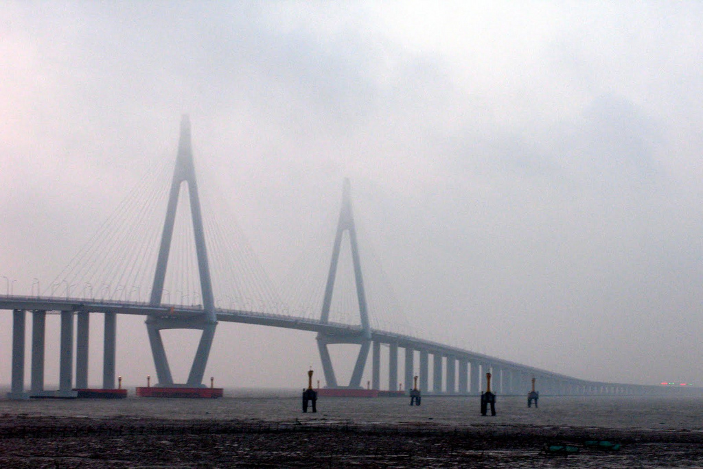
In the contemporary era, Hangzhou Bay has transformed into one of the most economically dynamic and technologically advanced maritime hubs on the planet, anchoring the southern flank of the Yangtze River Delta Economic Zone. The completion of the monumental Hangzhou Bay Bridge in 2008 represented a triumph of twenty-first-century structural engineering. Spanning thirty-six kilometers of open, tide-ripped water, the cable-stayed bridge was engineered to withstand catastrophic tidal bore wave impacts, deep sub-bottom scour, and typhoon-force gale winds, slashing the overland transit time between Ningbo and Shanghai from four hours to less than two hours.
However, this unprecedented industrial expansion and massive coastal land reclamation have placed intense ecological pressure on the bay’s natural ecosystems. Decades of land reclamation for industrial parks, container terminals, and aquaculture ponds eliminated over fifty percent of the bay’s pristine intertidal wetlands during the late twentieth century, constricting natural bird staging areas and altering the estuarine hydrodynamic balance. Furthermore, industrial wastewater discharge and agricultural runoff from the dense upstream river networks contributed to seasonal eutrophication and occasional red tide algal blooms.
Recognizing these severe environmental challenges, the provincial governments of Zhejiang and Shanghai, in cooperation with national environmental ministries, have instituted aggressive ecological remediation and wetland protection policies. Massive wetland conservation reserves, including the Cixi Hangzhou Bay National Wetland Park, have been established and restored, returning thousands of hectares of artificial fish ponds back to natural tidal marshland. Strict industrial emission caps, comprehensive sea-wall reinforcement programs, and automated hydrodynamic sensor buoys now ensure that Hangzhou Bay balances world-class port logistics with the enduring majesty of its legendary tidal waters.
The strategic importance of Hangzhou Bay was highlighted during the First Opium War (1839–1842), when British naval flotillas navigated its treacherous mud shoals to blockade the mouth of the Qiantang River and seize the fortified coastal cities of Zhenhai and Zhoushan. Royal Navy hydrographers struggled immensely against the fierce tidal currents and shifting sandbanks, suffering grounded gunboats and recognizing the estuary as one of the most navigationally hazardous seaways in Asia.
In modern coastal infrastructure, the construction of the Jiaxing-Shaoxing Sea Bridge (Jiashao Bridge) in 2013 provided a second monumental trans-estuarine link across Hangzhou Bay, spanning ten kilometers of turbulent water with a multi-tower cable-stayed design. Real-time satellite radar interferometry continuously monitors the structural stability of these mega-bridges against the relentless cyclic fatigue caused by hundreds of daily tidal bore impacts.
Frequently Asked Questions
What causes the famous tidal bore in Hangzhou Bay?
The tidal bore is generated by a combination of astronomical gravitational forces and extreme funnel-shaped coastal geomorphology. As the macro-tidal Atlantic-Pacific tide surges into the wide outer mouth of Hangzhou Bay (approximately one hundred kilometers wide), the waterway rapidly narrows and shoals to just a few kilometers near the Qiantang River mouth, forcing the incoming wall of water to pile up into a roaring, steep wave train that charges upstream.
Where is Hangzhou Bay situated in relation to China’s major river basins?
Hangzhou Bay is an inlet of the East China Sea located in northern Zhejiang province and southern Shanghai municipality. It receives the direct discharge of the Qiantang River at its head while being profoundly influenced by the immense sediment and freshwater outflow of the neighboring Yangtze River estuary to the north.
How long is the Hangzhou Bay Bridge and what purpose does it serve?
The Hangzhou Bay Bridge measures approximately 36 kilometers (22 miles) in length. Completed in 2008, it directly connects Jiaxing on the northern shore to Ningbo on the southern shore, slashing travel time between Ningbo and Shanghai by more than half and serving as a crucial economic artery within the Yangtze River Delta megacity cluster.
What ecological importance do the intertidal mudflats of Hangzhou Bay have for wildlife?
The expansive intertidal mudflats and salt marshes of Hangzhou Bay serve as an indispensable staging post along the East Asian–Australasian Flyway. Millions of migratory shorebirds, including critically endangered species such as the spoon-billed sandpiper and Far Eastern curlew, rely upon the rich benthic invertebrate fauna of the bay to refuel during their trans-continental journeys.




Share what you know
Been there, grew up there, or know something we missed? Add a comment; corrections with a source are especially welcome.