
The Siberian Arctic Shelf: Boundaries and Morphology
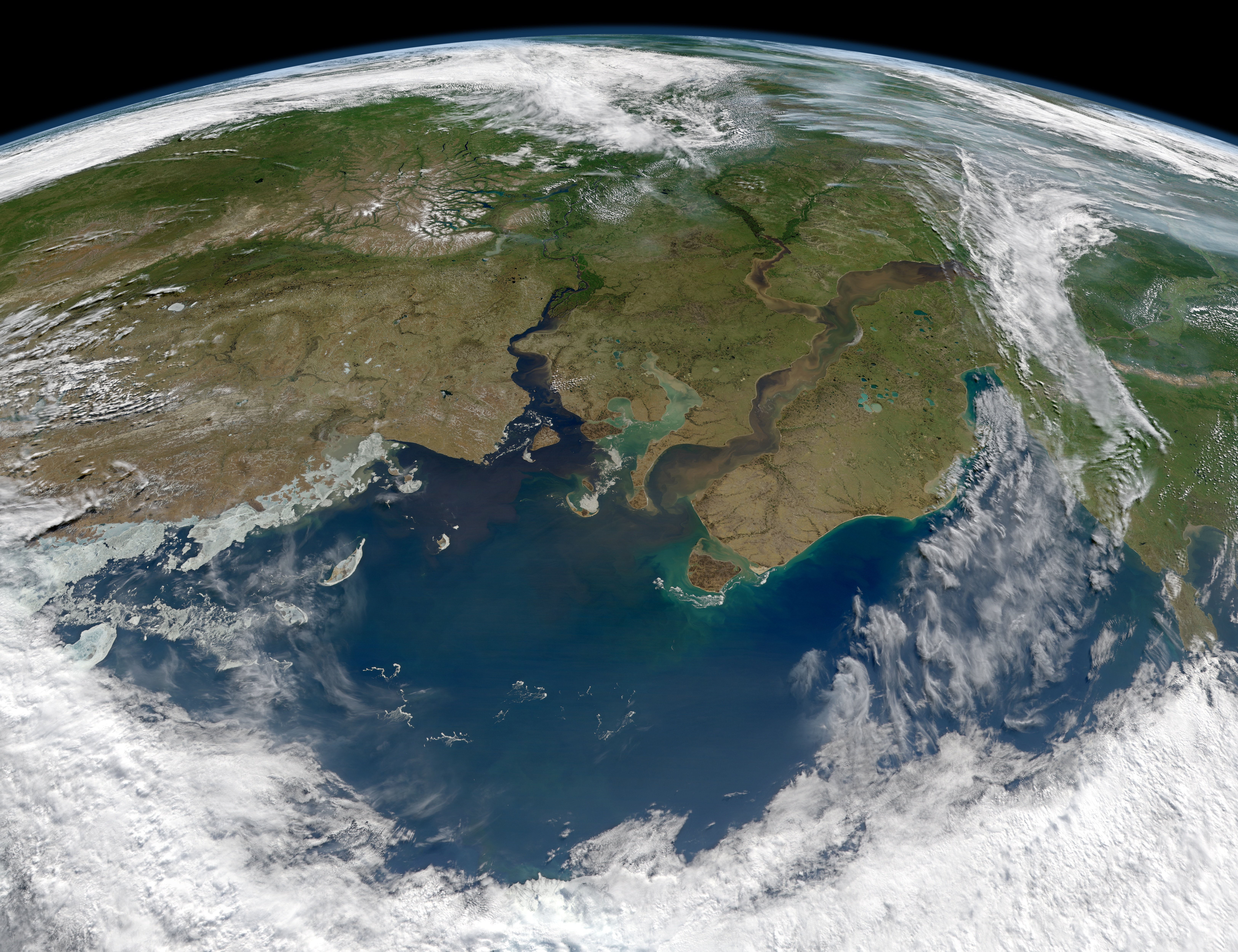
Frozen for most of the year beneath dense, grinding sheets of sea ice, the Kara Sea occupies a vast expanse of the Eurasian continental shelf along the northern perimeter of Siberia. Covering roughly eight hundred eighty thousand square kilometers, this marginal sea of the Arctic Ocean is bounded by dramatic natural barriers: to the west rises the rugged, glaciated arch of the Novaya Zemlya archipelago, separating it from the milder, Atlantic-influenced waters of the Barents Sea. To the east, the icy islands of Severnaya Zemlya and the barren headlands of the Taymyr Peninsula mark the transition into the Laptev Sea. To the south stretches the low, marshy tundra of the Yamal and Gydan peninsulas, while to the north, the shelf plunges into the deep Arctic abyss of the Nansen Basin.
The bathymetry of the Kara Sea is defined by its position on one of the widest and shallowest continental shelves on the planet. More than forty percent of the sea floor lies at depths of less than fifty meters, forming an extensive, gently sloping submarine plain. Across the southern and central sectors, immense mud flats and sandy banks extend for hundreds of kilometers offshore, deposited over millennia by the erosion of the Siberian interior. In these shallow shelf waters, navigation requires extreme caution, as uncharted shoals and shifting silt deposits lie concealed beneath murky, sediment-laden waters.
However, this gentle shelf is deeply dissected by two prominent submarine canyons: the Saint Anna Trough in the northwest and the Voronin Trough in the northeast. The Saint Anna Trough is a colossal underwater chasm that cuts southward from the central Arctic Ocean, reaching depths exceeding six hundred meters between Franz Josef Land and Novaya Zemlya. Through this deep corridor, warm, saline Atlantic water that entered the Arctic Ocean via the Fram Strait creeps southward along the seabed, bringing a subterranean pulse of ocean heat and nutrients that collides with the freezing, freshwater-dominated surface layers above. The eastern boundary of the Kara Sea along the Severnaya Zemlya archipelago features dramatic tidewater glaciers that spill directly from permanent ice caps into the sea. These glaciated headlands calve tabular icebergs into the Vilkitsky Strait, the narrow international shipping passage linking the Kara and Laptev seas. Through this rocky bottleneck, fierce currents and shifting ice floes create some of the most challenging navigational obstacles along the entire Northern Sea Route.
The Great River Plumes: Ob and Yenisei Inflows
The defining physical characteristic of the Kara Sea is its extraordinary hydrological relationship with the Siberian continent. The sea serves as the ultimate marine recipient of two of the largest river systems on planet Earth: the Ob River and the Yenisei River. Draining an immense continental catchment that stretches from the Altai Mountains and Lake Baikal across the West Siberian Plain to the Arctic shores, these two river giants discharge more than twelve hundred cubic kilometers of freshwater into the Kara Sea every single year. This monumental influx accounts for more than one-third of all river runoff entering the entire Arctic Ocean, making the Kara Sea the most river-influenced marine basin on the planet.
The geography of these river mouths is colossal in scale. The Ob River empties into the Gulf of Ob, an immense, narrow marine inlet extending inland for more than eight hundred kilometers, making it the longest estuary in the world. Directly to the east, the Yenisei River pours through the Yenisei Gulf, discharging powerful currents laden with suspended sediments, organic carbon, and terrestrial minerals. During the brief summer thaw between June and August, peak meltwater floods rush out of the Siberian forests, turning coastal waters brown and green with sediment plumes that spread hundreds of kilometers northward across the shelf.
This freshwater flood generates an intense, low-density surface lens that caps the sea. In summer, surface salinity across large areas of the central and southern Kara Sea drops to between ten and twenty parts per thousand, and near the river mouths, the water is virtually fresh. This light, brackish surface layer is separated from the cold, dense, saline marine water below by an extremely sharp halocline at a depth of ten to fifteen meters.
The ecological and cryospheric implications of this stratification are profound. Because low-salinity water freezes at higher temperatures than normal seawater, the freshwater plume accelerates ice formation in late autumn. Furthermore, the sharp halocline prevents vertical heat exchange, trapping summer solar warmth near the surface while preventing deep Atlantic waters from melting the overlying ice, reinforcing the sea’s reputation as a relentless ice factory. This immense freshwater discharge also carries colossal quantities of dissolved organic carbon, silica, and terrestrial nutrients eroded from the permafrost soils of the Siberian taiga. In summer, as sunlight warms the shallow estuaries, this fluvial banquet fuels prolific blooms of brackish diatoms and green algae, transforming the river mouths into fertile feeding grounds for millions of juvenile whitefish (Coregonus) that undertake seasonal migrations between the rivers and coastal bays.
The Arctic Ice Cellar: Cryospheric Regimes

For nine to ten months of every year, the Kara Sea is locked in the grip of the polar cryosphere. Historical Russian navigators and explorers dubbed it the ‘Ice Cellar’ (Ledyanoy Pogreb) because, unlike the Barents Sea, which benefits from the warming terminus of the Gulf Stream, the Kara Sea is largely cut off from direct Atlantic surface currents by the mountain wall of Novaya Zemlya. Under the cover of the long polar night, when the sun disappears below the horizon for months and air temperatures plummet below minus forty degrees Celsius, the sea undergoes rapid, total freeze-up.
Ice growth begins in late September in the shallow, brackish bays of the south and quickly spreads across the open shelf. By midwinter, three distinct sea ice regimes dominate the basin. Along the mainland coast, solid fast ice forms, attached firmly to the shore and extending tens of kilometers out into the sea, freezing to depths of up to two meters. Beyond the fast ice lies the mobile pack ice—a churning labyrinth of pressure ridges, hummocks, and drifting floes that grind against one another under the influence of fierce Arctic blizzards. In the northern reaches, massive multi-year ice floes drift southward from the central Arctic pack, creating impenetrable fields of ice that can crush conventional ships like eggshells.
Between the stationary fast ice and the drifting pack ice lies one of the most critical cryospheric features of the Kara Sea: the Great Siberian Flaw Polynya. Driven by offshore winds blowing continuously from the Siberian mainland, new ice is constantly blown away from the fast ice edge, leaving open ribbons of water that remain unfrozen even during the depths of winter. These flaw polynyas function as giant atmospheric radiators, releasing immense amounts of heat and moisture into the polar air while generating brine as new ice continuously forms on the exposed water.
In summer, the breakup of the ice is slow and unpredictable. Melting begins in late June under continuous twenty-four-hour daylight, aided by the warm freshwater pulses of the Ob and Yenisei. However, persistent northeasterly winds can herd heavy pack ice against the eastern coast of Novaya Zemlya, keeping the Kara Strait choked with drifting icebergs and floes well into August, reminding mariners of the formidable physical barriers that long guarded this frozen realm.
The Northern Sea Route and Polar Pioneers
The icy waters of the Kara Sea have challenged polar explorers and navigators for centuries, serving as the critical gateway and the most formidable obstacle along the historic Northeast Passage. During the sixteenth and seventeenth centuries, intrepid Russian coastal seafarers known as Pomors sailed light, flexible wooden vessels called koches through the Kara Strait, trading with indigenous Nenets hunters for walrus ivory, seal skins, and precious sables. They established Mangazeya, a legendary fur-trading emporium on the Taz River that flourished briefly as a wealthy Arctic metropolis before its overland routes were closed by imperial decree.
Western European explorers also sought a northern sea route to China and the Indies through these waters. In fifteen ninety-six, the celebrated Dutch navigator Willem Barentsz attempted to round the northern tip of Novaya Zemlya, but his ship was trapped by heavy Kara Sea pack ice, forcing his crew to survive the brutal Arctic winter in a shelter built from driftwood before retreating in open boats. It was not until eighteen seventy-eight that Finnish-Swedish explorer Adolf Erik Nordenskiöld aboard the steamship Vega successfully navigated the entire length of the Kara Sea, passing Dikson and the Taymyr Peninsula to complete the first transit of the Northeast Passage in history.
In the twentieth century, the Soviet Union transformed the Kara Sea from an exploratory frontier into an industrial maritime corridor: the Northern Sea Route (Severny Morskoy Put). At the southern gateway of the Yenisei Gulf, the port of Dikson was established in nineteen fifteen, growing into a strategic polar base with radio stations, meteorological observatories, and coaling depots. Dikson earned heroic renown during World War II when, in August nineteen forty-two, its garrison and the armed icebreaker Dezhnev repelled an attack by the German heavy cruiser Admiral Scheer, saving the port and securing Allied Arctic supply convoys.
Today, the Northern Sea Route through the Kara Sea is experiencing a modern renaissance driven by climate warming and resource extraction. Nuclear-powered icebreakers of the Rosatomflot fleet—such as the massive Arktika and Sibir—maintain open navigation channels through the pack ice year-round. These atomic leviathans escort giant ice-class Arc7 liquefied natural gas (LNG) carriers transiting from production terminals on the Yamal Peninsula, transporting Arctic energy across the globe and rewriting the economics of Eurasian shipping. The strategic isolation of the Kara Sea also made it the setting for daring Cold War confrontations. Throughout the nineteen fifties and sixties, American icebreakers and reconnaissance vessels attempted clandestine passages through the Vilkitsky Strait to survey Soviet Arctic naval bases, shadowed closely by Soviet patrol planes and icebreakers in tense, silent standoffs amidst the fog and pack ice of the High North.
Benthic Ecology, Nuclear Legacy, and Modern Pressures
Beneath its ice-locked surface, the Kara Sea supports a uniquely adapted, highly specialized marine ecosystem. Despite low water temperatures and nine months of winter darkness, primary production surges explosively during the brief polar summer. In the deep waters of the Voronin Trough, international benthic scientists have documented extensive communities of deep-sea cold-water corals and glass sponges that filter organic marine snow drifting downward from the productive surface waters above. Diatom blooms flourish along the melting ice edges and within the nutrient-rich river plumes, fueling dense populations of herbivorous copepods and pelagic amphipods. These plankton swarms sustain the polar cod (Boreogadus saida), an indispensable keystone fish species that feeds in vast schools beneath the pack ice.
The polar cod in turn provides the vital caloric link supporting apex Arctic predators. Pods of white beluga whales (Delphinapterus leucas) navigate deep into the estuaries of the Ob and Yenisei to feed on migrating fish, their smooth white bodies visible in the brackish shallows. Ringed seals and bearded seals maintain breathing holes through the thick fast ice, haul out on drifting floes, and raise their pups sheltered from the fierce winds. On the pack ice, the undisputed monarch of the Kara Sea—the polar bear (Ursus maritimus)—roams hundreds of kilometers in search of seals, their tracks crisscrossing the frozen expanses from Novaya Zemlya to Severnaya Zemlya.
Along the remote coastlines, dramatic rocky headlands host sprawling bird colonies where millions of thick-billed murres, black-legged kittiwakes, and little auks nest on vertical cliffs, while secluded gravel beaches shelter herds of Pacific and Atlantic walruses. In the soft muds of the continental shelf, dense communities of brittle stars, sea cucumbers, and bivalves process organic carbon transported by the great Siberian rivers, cycling nutrients through cold benthic ecosystems.
However, the Kara Sea also carries somber ecological burdens from the twentieth century. Between nineteen fifty-five and nineteen ninety, the southern island of Novaya Zemlya served as the principal Soviet nuclear testing range, witnessing dozens of atmospheric and underground nuclear detonations, culminating in the test of the fifty-megaton Tsar Bomba in nineteen sixty-one. In addition, thousands of containers of low-level radioactive waste, alongside several decommissioned nuclear submarine reactors, were disposed of in deep submarine troughs along the eastern coast of Novaya Zemlya during the Cold War.
Over the past three decades, joint international scientific expeditions led by the International Atomic Energy Agency (IAEA) and Russian oceanographic institutes have continuously monitored these deep disposal sites, finding that the radioactive material remains largely contained within protective casings and benthic sediments. Modern environmental stewardship in the Kara Sea faces the dual challenge of continuing this vigilant radiological monitoring while managing the rapid expansion of oil and gas exploration, Arctic shipping, and accelerating permafrost thaw. As climate change thins the ancient pack ice, safeguarding this pristine, severe Siberian sea demands an enduring commitment to international scientific cooperation and responsible Arctic development. The coastal mudflats and tundra margins also host significant breeding populations of Arctic foxes (Vulpes lagopus) and lemmings, whose population fluctuations directly influence the reproductive success of snowy owls and skuas that patrol the windswept shorelines during the brief polar summer. In the deep waters of the Voronin Trough, international benthic scientists have documented extensive communities of deep-sea cold-water corals and glass sponges that filter organic marine snow drifting downward from the productive surface waters above.
Frequently Asked Questions
Where is the Kara Sea and what are its boundaries?
The Kara Sea is a marginal sea of the Arctic Ocean located off the coast of northwestern Siberia. It is bounded to the west by the Novaya Zemlya archipelago and the Kara Strait (which separate it from the Barents Sea), to the east by the Severnaya Zemlya archipelago and the Taymyr Peninsula (which separate it from the Laptev Sea), to the south by the Siberian mainland, and to the north by the Arctic Ocean basin.
Why is the Kara Sea so cold and ice-covered?
The Kara Sea is exceptionally cold and ice-bound because it lies deep within the Arctic Circle (between seventy and eighty degrees north latitude) and is largely cut off from the warm Atlantic currents that keep the neighboring Barents Sea ice-free. Furthermore, massive freshwater discharges from Siberian rivers lower surface water salinity, allowing ice to freeze at higher temperatures than normal seawater. Pack ice covers up to ninety percent of the sea for nine to ten months each year.
What rivers flow into the Kara Sea?
The Kara Sea is fed by two of the mightiest rivers in Asia: the Ob River and the Yenisei River, alongside smaller streams like the Pyasina, Pur, and Taz. The Ob enters through the enormous, eight-hundred-kilometer-long Gulf of Ob, while the Yenisei discharges through the Yenisei Gulf. Together, these rivers drain immense swathes of western and central Siberia, carrying tremendous volumes of freshwater, nutrients, and sediments into the shallow Arctic shelf.
Is the Kara Sea navigable for commercial ships?
Navigating the Kara Sea is challenging and historically perilous due to persistent sea ice, shallow waters, and winter darkness. However, it forms a central link in the Northern Sea Route (NSR). With modern nuclear-powered icebreakers and ice-class commercial vessels, the sea is increasingly navigated year-round, transporting liquefied natural gas (LNG) from the Yamal and Gydan peninsulas to European and Asian markets.








Share what you know
Been there, grew up there, or know something we missed? Add a comment; corrections with a source are especially welcome.