
The Continental Threshold: Geography, Dimensions, and Bathymetry
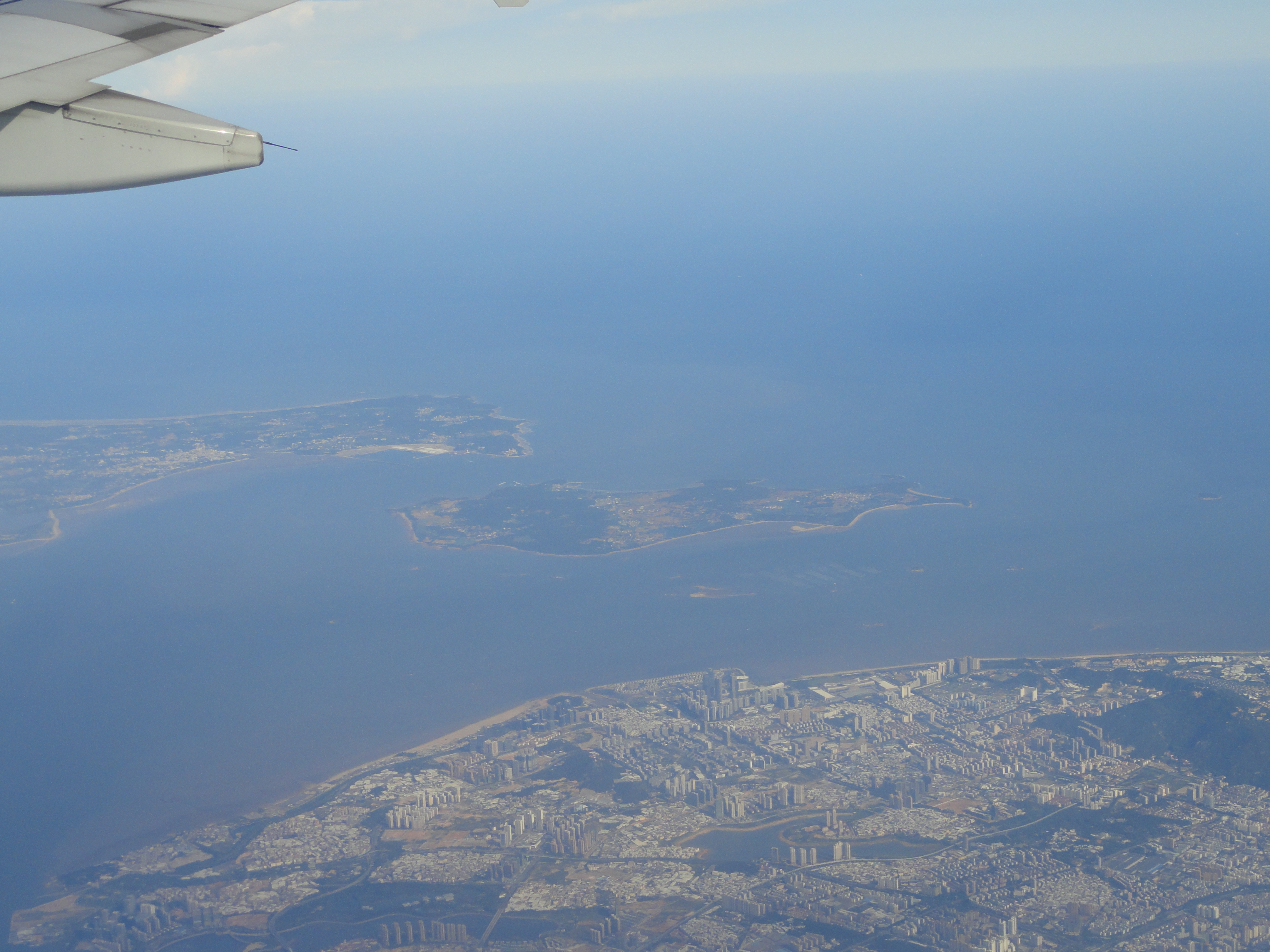
The Taiwan Strait—known historically in Western navigation as the Formosa Strait and in Chinese as the Taiwan Haixia—is an expansive epicontinental seaway separating the island of Taiwan from the southeastern coast of mainland China’s Fujian Province. Extending approximately three hundred and eighty kilometers from its northern boundary facing the East China Sea to its southern margin opening into the South China Sea, the waterway forms one of the most commercially critical and strategically sensitive maritime corridors on Earth.
The strait spans an average width of one hundred and eighty kilometers, contracting to a narrow constriction of roughly one hundred and thirty kilometers between the granite promontories of Pingtan Island in Fujian and the alluvial coast of Hsinchu in northwestern Taiwan. Unlike deep oceanic trenches, the Taiwan Strait is situated entirely on the Eurasian continental shelf, characterized by shallow bathymetry that averages only sixty meters along its central navigational axis.
The seabed morphology is distinguished by dramatic underwater topographies. In the southwest lies the vast submarine dune field of the Taiwan Shoals (Taiwan Bank), where underwater sand ridges rise to within ten to fifteen meters of the surface, creating severe navigational hazards for deep-draft vessels. In contrast, along the southeastern margin of the strait, the seabed drops into the submarine gorge of the Penghu Channel, where depths plunge beyond one hundred and fifty meters, funneled between the volcanic Penghu Archipelago and the coastal plains of Chiayi.
The geological structure beneath the Taiwan Strait is characterized by three major sedimentary basins: the Western Taiwan Basin, the Penghu Basin, and the Taixi Basin. Formed during Cenozoic continental rifting, these tectonic grabens contain up to five thousand meters of Tertiary marine and fluvial sediments. Over the past five million years, as the Philippine Sea Plate collided with the Eurasian continental margin to uplift the central mountain ranges of Taiwan, tremendous volumes of erosional sediment were washed westward into the strait, filling these ancient grabens and creating the shallow continental shelf that exists today.
The bathymetry in the northern entrance transitions into the broad continental shelf of the East China Sea, where the seafloor slopes gently toward the Okinawa Trough. Along this northern shelf, sand ridges and mud wedges deposited by the ancient Yangtze River plume extend into the strait, creating an extensive benthic environment characterized by high acoustic backscatter and dynamic sediment bedforms that shift under the influence of strong semidiurnal tidal currents.

Oceanic Crossroads: The Monsoon Funnel and Competing Currents
The physical oceanography of the Taiwan Strait is an extraordinary study in hydrodynamic complexity, driven by seasonal monsoon winds and the collision of contrasting oceanic water masses. During the winter months from October to April, the powerful Northeast Monsoon funnels through the strait between the Central Mountain Range of Taiwan and the coastal cordilleras of mainland China. This geographic compression creates a wind-tunnel effect, accelerating wind speeds into sustained gale-force squalls and generating steep, short-period waves that batter passing shipping.
These winter gales drive the cold, brackish, sediment-laden China Coastal Current southward along the Fujian coast. Concurrently, from the south, the deep, warm, and highly saline Kuroshio Branch Current pushes northward through the Penghu Channel, colliding with the cold coastal flow. This hydrodynamic collision establishes a sharp oceanic front that bisects the strait, characterized by dramatic gradients in water temperature, salinity, and water clarity.
During the summer Southwest Monsoon from June to August, the circulation regime reverses. Southerly winds drive warm water from the South China Sea northward through the entire width of the strait into the East China Sea at velocities exceeding two knots. This massive northward flux transports vast quantities of heat, salt, and dissolved nutrients from tropical basins to temperate East Asian waters, acting as a crucial component of the regional climate system.
The coastal upwelling dynamics of the western Taiwan Strait represent a vital ecological and oceanographic phenomenon. During the summer Southwest Monsoon, persistent southerly wind stress drives offshore Ekman transport along the rugged coast of Fujian, pulling cold, nutrient-rich subsurface water up from the seabed along the Dongshan and Minjiang coastal margins. This coastal upwelling enriches surface waters with high concentrations of dissolved silicates and nitrates, sparking explosive summer diatom blooms that fuel extensive coastal mariculture industries specializing in kelp, oysters, and abalone.
The Drowned Steppe: The Prehistoric Taiwan Land Bridge
From a geological perspective, the modern marine state of the Taiwan Strait represents a relatively brief interlude in Quaternary earth history. Because the strait’s maximum depth averages merely sixty meters, the slightest drop in global sea level radically transforms the regional geography. Throughout the repeated glacial epochs of the Pleistocene, when global sea levels plunged by one hundred to one hundred and twenty meters, the entire Taiwan Strait emerged as a vast, dry continental plain known as the Taiwan Land Bridge.
During the Last Glacial Maximum, roughly twenty thousand years ago, the floor of the strait was an expansive, temperate savanna and river plain dissected by ancient fluvial systems. Herds of Pleistocene megafauna—including the steppe elephant (Palaeoloxodon huaihoensis), woolly rhinoceros, giant deer, and primitive water buffalo—migrated freely across this grassland between the Asian mainland and the mountain refugia of Taiwan.
Fishermen trawling the seabed of the Taiwan Shoals and the Penghu Channel routinely recover thousands of fossilized mammalian bones, tusks, and teeth dating to these glacial stages. In two thousand eight, a remarkable fossil find—a prehistoric human jawbone designated Penghu 1—was dredged from the seabed at depths of twenty meters. Analysis revealed it to belong to an archaic hominin species that lived on the exposed floor of the strait between one hundred thousand and two hundred thousand years ago, testifying to an ancient human presence on land that is now covered by twenty fathoms of saltwater.
The archaeological and paleontological significance of the exposed Taiwan Land Bridge has been enriched by the discovery of stone tools dredged from the floor of the strait alongside Pleistocene megafaunal fossils. Prehistoric hunter-gatherers exploited the abundant freshwater rivers and wildlife herds roaming the exposed savannah plains during glacial stages. When post-glacial sea levels rose between twelve thousand and eight thousand years ago, this thriving terrestrial biome was rapidly submerged, preserving an ancient submerged landscape that marine archaeologists are only beginning to map using high-resolution sub-bottom sonar profiling.
Ecological Crossings: Fisheries and the Endangered White Dolphin
The convergence of contrasting water masses and nutrient-rich seasonal upwellings makes the Taiwan Strait one of the most productive marine fishing grounds in the Western Pacific. Prolific blooms of diatoms and dinoflagellates nourish immense concentrations of zooplankton, supporting commercial fisheries that have sustained coastal communities for centuries. Key commercial species include Spanish mackerel, largehead hairtail, Japanese anchovy, round scad, and neritic squid, which congregate around the underwater banks and submarine sills.
The shallow coastal waters along the eastern margin of the strait harbor one of the planet’s most critically endangered cetaceans: the Taiwanese humpback dolphin (Sousa chinensis taiwanensis), commonly known as the Taiwanese white dolphin or Matsu’s fish (because it frequently appears in coastal waters around the spring festival of the sea goddess Mazu). Characterized by its distinctive pale pink coloration in adulthood, this genetically isolated population numbers fewer than seventy individuals, confined entirely to an eight-hundred-square-kilometer coastal strip between Miaoli and Tainan.
These delicate coastal cetaceans face severe survival threats from intensive human activities, including habitat loss from industrial coastal reclamation, acoustic disturbance from maritime traffic and offshore pile driving, and accidental entanglement in gillnets. Conservation biologists and environmental authorities have established protected marine corridors and acoustic monitoring programs to safeguard this iconic marine species.
The physical oceanography of the eastern Taiwan Strait creates specialized estuarine mixing zones around the mouths of major rivers draining Taiwan’s western plains, such as the Dajia, Zhuoshui, and Zengwun rivers. These river systems deliver freshwater, dissolved nutrients, and terrestrial silts into the shallow coastal shelf, creating turbid, nutrient-rich brackish waters that support prolific populations of coastal schooling fish. It is precisely within these estuarine plumes that the endangered Taiwanese white dolphins prefer to forage, using specialized acoustic biosonar to hunt benthic fish along the sandy seabed in low-visibility conditions.
The preservation of the Taiwanese white dolphin has driven pioneering marine spatial planning across the eastern strait. In twenty twenty, Taiwan officially designated over seven hundred and sixty square kilometers of coastal waters as the Taiwanese White Dolphin Major Wildlife Habitat. This protected corridor restricts bottom trawling, enforces acoustic noise limits during offshore wind turbine installation, and mandates dedicated marine mammal observers aboard all construction vessels, establishing a model for balancing renewable energy development with the conservation of critically endangered cetaceans.
The Stone Fortresses: The Penghu Archipelago and Ancient Mariners
At the geographic heart of the strait lies the Penghu Archipelago, known historically in the West as the Pescadores (the ‘Fishermen’s Islands’). Comprising ninety volcanic basalt islands and islets, Penghu was formed by successive fissure eruptions of basaltic lava during the Miocene epoch. Cooling lava created monumental cliffs of vertical hexagonal basalt columns that rise dramatically from the sea, serving as natural sea walls against the ferocious winter monsoon.
For over a millennium, Penghu served as an indispensable maritime stepping-stone for Chinese, Japanese, and Southeast Asian mariners navigating the hazardous waters of the strait. During the Ming and Qing dynasties, the islands were fortified with stone fortresses to guard against wokou pirate fleets and Western naval incursions. In sixteen twenty-two, the Dutch East India Company established a wooden fort on Penghu before being expelled by Ming forces to southwest Taiwan, where they founded Fort Zeelandia.
To harvest fish in this storm-swept environment, generations of Penghu fishermen developed an ingenious indigenous engineering marvel: stone tidal weirs (shihu). Constructing massive circular stone walls using local basalt and coral stone on intertidal reef flats, fishermen trapped migrating fish as the tide receded. The most famous of these—the Double-Heart of Stacked Stones on Qimei Island—remains an enduring symbol of human harmony with the relentless tides of the strait.
The architectural heritage of the Penghu Islands in the central strait is directly adapted to survive the fierce salt-laden winter gales. Traditional houses in villages such as Erkan on Xiyu Island are constructed from blocks of porous coral stone (known as coral limestone or coquina) and dense columnar basalt. The surrounding agricultural fields are fortified with protective stone walls, called caizhai, built high to shelter delicate crops of sweet potatoes, melons, and peanuts from the corrosive sea spray and gale-force winds of the Northeast Monsoon, showcasing human ingenuity on the windswept waters of the strait.
The geological wonders of the Penghu Islands extend beneath the waves into extraordinary subaquatic basalt formations. Underwater surveys around Tongpan and Hujing islands reveal submerged hexagonal basalt columns and submerged structural walls that have fueled colorful local legends of sunken ancient civilizations, often popularized in folklore as the ‘Penghu Submarine Ancient City.’ Marine geologists, however, have confirmed that these underwater structures are natural columnar basalt jointing formations created by Miocene volcanic cooling, offering some of the most spectacular subsea geological diving landscapes in the Western Pacific.
In historical navigation, traditional Taiwanese and Fujianese mariners relied upon celestial navigation and empirical seasonal charts to time their transits across the treacherous black water of the strait, known colloquially as the Heishuigou (Black Water Ditch). The deep trench of the Penghu Channel, where deep clear oceanic waters absorb red sunlight to appear ominously dark compared to yellow coastal shallows, tested generations of Chinese migrants sailing wooden junks during the Ming and Qing dynasties, giving rise to rich seafaring folk traditions and widespread devotion to the sea goddess Mazu.
The Global Highway: Modern Shipping, Offshore Wind, and Geopolitics
In the contemporary era, the Taiwan Strait occupies a position of extraordinary prominence in international commerce, clean energy transition, and global geopolitics. The waterway serves as a primary international maritime artery, transited annually by nearly half of the global container ship fleet and carrying essential mineral and energy imports between Northeast Asia, Southeast Asia, and Europe. Navigating these shallow, congested waters requires absolute navigational care to avoid moving traffic lanes, thousands of small fishing vessels, and hazardous underwater shoals.
Simultaneously, the ferocious wind dynamics of the strait have made it the epicenter of a historic green energy revolution. Because the strait acts as a geographic funnel for the Northeast Monsoon, it possesses some of the highest and most consistent offshore wind speeds on the planet. Taiwan has capitalized on this natural asset by constructing massive offshore wind farms across the eastern strait, installing hundreds of advanced wind turbines that generate gigawatts of clean electricity, transforming the seascape into a modern laboratory of renewable marine power.
Yet above these technological triumphs looms the strait’s complex geopolitical reality. As the physical divide between Taiwan and mainland China, the Taiwan Strait remains one of the world’s most scrutinized flashpoints. Navies from across the globe conduct regular freedom-of-navigation transits through the international fairway, underscoring the universal principle that this narrow continental channel remains a shared global commons, vital to international peace, commerce, and environmental security.
The environmental monitoring of the Taiwan Strait has entered a high-tech era driven by satellite remote sensing, high-frequency coastal radar systems, and autonomous ocean buoys. Oceanographic institutions on both shores track surface currents, sea surface temperatures, and chlorophyll concentrations in real time, monitoring the seasonal migration of the Kuroshio branch current and forecasting typhoon storm surges. These scientific initiatives contribute to maritime safety and provide critical ecological data needed to manage the fragile marine ecosystems of this continental strait.
The economic significance of the Taiwan Strait is further underscored by the volume of semiconductor and high-tech supply chains that traverse its waters and surrounding airspace. Advanced microelectronics manufactured in science parks along Taiwan’s western coastal corridor are transported via maritime container feeders and air cargo routes across the strait to regional assembly hubs throughout East Asia. Consequently, the uninterrupted commercial transit of the strait is recognized by international economists as an indispensable artery for the functioning of the contemporary digital world.
Frequently Asked Questions
How wide and deep is the Taiwan Strait?
The Taiwan Strait measures approximately one hundred and eighty kilometers (one hundred and ten miles) wide on average, contracting to roughly one hundred and thirty kilometers (eighty-one miles) at its narrowest point between Pingtan Island in Fujian and Hsinchu in northwestern Taiwan. It is a shallow epicontinental sea, averaging merely sixty meters (two hundred feet) in depth across its central axis, though it plunges abruptly into the deep Penghu Channel and the South China Sea abyssal basin in the south.
Why is the weather in the Taiwan Strait so notoriously rough?
The strait sits directly between the massive continental landmass of Eurasia and the Pacific Ocean. During the winter months (October to March), cold high-pressure air masses from Siberia drive the powerful Northeast Monsoon south. As these winds encounter the high mountain ranges of Taiwan (reaching nearly four thousand meters) and the coastal hills of Fujian, the strait acts as a colossal geographic funnel. The compressed air accelerates violently, generating sustained gale-force winds, violent chop, and dense sea spray that have historically challenged mariners.
What is the biological importance of the Taiwan Strait for marine life?
The strait serves as a vital biogeographic corridor where warm, oligotrophic water from the Kuroshio Branch Current and South China Sea Warm Current collides with cold, nutrient-rich coastal water from the China Coastal Current. This intense mixing creates prolific seasonal plankton blooms that sustain major commercial fisheries for Spanish mackerel, ribbonfish, squid, and anchovy. The shallow western waters are also the critical habitat for the critically endangered Taiwanese white dolphin (Sousa chinensis taiwanensis).
What was the prehistoric Taiwan Land Bridge?
During the Pleistocene glaciations, when global sea levels were one hundred and twenty meters lower than today, the shallow waters of the Taiwan Strait receded completely, exposing a wide continental plain known as the Taiwan Land Bridge. This terrestrial corridor allowed early humans (such as the Penghu 1 archaic hominin) and Pleistocene mammals—including mammoth ancestors, stegodonts, wild cattle, and spotted hyenas—to cross between mainland Asia and Taiwan, shaping the island’s unique biological and archaeological heritage.





Share what you know
Been there, grew up there, or know something we missed? Add a comment; corrections with a source are especially welcome.