TERRITORY PORTRAIT · THE WORLD ATLAS

French Southern Territories

Find its place in the atlas, explore connected regions and follow the stories as they grow.

Find on the world map

Photo: Avaugour Francis / Wikimedia Commons (resized) Image licenceCC0Photograph by Avaugour Francis / Wikimedia Commons (resized). Display crop may differ from the original.

AT A GLANCE

French Southern Territories in facts

  • CapitalPort-aux-Français
  • Population140http
  • Area7,829 km²Ile Amsterdam (Ile Amsterdam et Ile Saint-Paul): less than one-half the size of Washington, D.C. | | Ile Saint-Paul (Ile Amsterdam et Ile Saint-Paul): more than 10 times the size of the National Mall in Washington, D.C. | | Iles Crozet: about twice the size of Washington, D.C. | | Iles Kerguelen: slightly larger than Delaware | | Bassas da India (Iles Eparses): land area about one-third the size of the National Mall in Washington, D.C. | | Europa Island (Iles Eparses): about one-sixth the size of Washington, D.C. | | Glorioso Islands (Iles Eparses): about eight times the size of the National Mall in Washington, D.C. | | Juan de Nova Island (Iles Eparses): about seven times the size of the National Mall in Washington, D.C. | | Tromelin Island (Iles Eparses): about 1.7 times the size of the National Mall in Washington, D.C
  • CurrencyEuro
Map: Natural Earth (public domain) · Open in the world map
All geographic & statistical details (23)
Density
0 people per km²
Official name
Territory of the French Southern and Antarctic Lands
Local name
Terres Australes et Antarctiques Françaises
World region
Africa · Sub-Saharan Africa · Eastern Africa
Official language
French
People are called
French
Founded
1955
Time zones
UTC+04:00, UTC+05:00, UTC+10:00
Drives on the
right
Land borders
None
Coastline
28 km
Administrative subdivisions
5 first-order regions
Topographic elevation profile
Mont Ross 1,850 m
0 mIndian Ocean▲ 1,850 mSummit
Railways & airports
4 airports
Climate
Ile Amsterdam et Ile Saint-Paul: oceanic with persistent westerly winds and high humidity | | Iles Crozet: windy, cold, wet, and cloudy | | Iles Kerguelen: oceanic, cold, overcast, windy | | Iles Eparses: tropical
Terrain
Ile Amsterdam (Ile Amsterdam et Ile Saint-Paul): a volcanic island with steep coastal cliffs; the center floor of the volcano is a large plateau | | Ile Saint-Paul (Ile Amsterdam et Ile Saint-Paul): triangular in shape, the island is the top of a volcano, rocky with steep cliffs on the eastern side; has active thermal springs | | Iles Crozet: a large archipelago formed from the Crozet Plateau is divided into two groups of islands | | Iles Kerguelen: the interior of the large island of Ile Kerguelen is composed of high mountains, hills, valleys, and plains with peninsulas stretching off its coasts | | Bassas da India (Iles Eparses): atoll, awash at high tide; shallow (15 m) lagoon | | Europa Island, Glorioso Islands, Juan de Nova Island: low, flat, and sandy | | Tromelin Island (Iles Eparses): low, flat, sandy; likely volcanic seamount
Natural resources
fish, crayfish, note, Glorioso Islands and Tromelin Island (Iles Eparses) have guano, phosphates
+ 1 moreShow lessand coconuts
Internet domain
.tf
ISO & UN codes
TF · ATF · M49 260
Name origin
Self-descriptive name specifying the territories' affiliation and location in the Southern Hemisphere
Names in other languages
Terre Australi e Antartiche Francesi, أراض فرنسية جنوبية وأنتارتيكية, Französische Süd- und Antarktisgebiete, Tierras Australes y Antárticas Francesas, سرزمینهای جنوبی و جنوبگانی فرانسه, Terres australes et antarctiques françaises
+ 19 moreShow lessફ્રેન્ચ સધર્ન એન્ડ એન્ટાર્કટિક લેન્ડ્સ, दक्षिण फ्रांसीसी और अंटार्कटिक लैंड, Daratan Selatan dan Antarktika Perancis, フランス領南方・南極地域, ಫ್ರೆಂಚ್ ದಕ್ಷಿಣ ಮತ್ತು ಅಂಟಾರ್ಕ್ಟಿಕ್ ಭೂಪ್ರದೇಶಗಳು, 프랑스령 남방 및 남극 지역, फ्रान्सचे दक्षिणी व अंटार्क्टिक भूभाग, Franse Zuidelijke Gebieden, Francuskie Terytoria Południowe i Antarktyczne, Terras Austrais e Antárticas Francesas, Французские Южные и Антарктические территории, பிரெஞ்சு தென்னக நிலங்களும் அண்டார்க்டிக் நிலமும், ఫ్రెంచ్ సదరన్ మరియు అంటార్కిటిక్ లాండ్స్, เฟรนช์เซาเทิร์นและแอนตาร์กติกแลนดส์, Fransız Güney ve Antarktika Toprakları, Французькі Південні і Антарктичні території, سرزمین جنوبی فرانسیسیہ و انٹارکٹیکا, Vùng đất phía Nam và châu Nam Cực thuộc Pháp, 法属南部和南极领地
Capital location
49.4°S, 70.2°E

Facts: Wikidata Q129003 and the CIA World Factbook (public domain: geography, demographics, borders, coastline and symbols), retrieved 1 November 2026. Figures can change; check the source for the latest.

FLAG & SYMBOLS

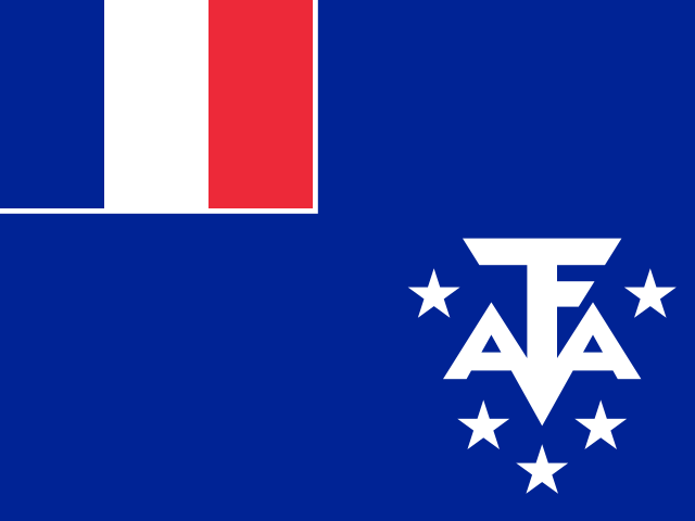
The flag and symbols of French Southern Territories

The flag

The flag of France is used.

Coat of arms
Coat of arms or emblem of French Southern Territories

Image: Superbenjamin / Wikimedia Commons · CC BY-SA 4.0

National anthem

"La Marseillaise" (The Song of Marseille)
Claude-Joseph Rouget de Lisle

Flag description and meaning, colours, symbols, anthem details, national day and independence: CIA World Factbook (public domain). Coat of arms, motto and recording: Wikidata and Wikimedia Commons (credited above). Flag artwork: flag-icons (MIT), retrieved 1 November 2026.

There is more to explore.Discover the regions of French Southern TerritoriesExplore regions
ON THE ATLAS · CHRONICLE IN PREPARATION

Discover French Southern Territories

This is a sourced directory entry. A researched regional chronicle and verified location photography are in preparation.

Overseas territory

French overseas association: France. Status & relationship source ↗

A CLOSER LOOK

Explore the regions

5 entries

Explore the first-order regions in this GeoNames snapshot. Local names and levels vary.

Names and immediate parent assignments: GeoNames, CC BY 4.0, 28 October 2026. Unspecified code 00 excluded. This is not an exhaustive list of districts, counties or municipalities. Photographs are credited individually beneath each image; one pictured place does not represent every landscape in its region.

FROM THE JOURNAL

Stories from French Southern Territories

Our editorial journey here is still ahead. No researched stories have been published for this place yet.

Explore published stories →
HELP US GET IT RIGHT

Suggest a correction

Spotted a factual issue, a wrong location or a missing image credit? Tell us what needs checking.

Send a correction

Saved privately for editorial review. Please do not include personal information. Reports do not change the article automatically.

CONVERSATION

Share what you know

Been there, grew up there, or know something we missed? Add a comment; corrections with a source are especially welcome.

Leave a comment

Your email address is never published. Comments are read before they appear. See our Privacy Policy.

Directory: UN M49 countries or areas, with 193 UN members, 2 observers and 53 other areas. Subdivisions: GeoNames, CC BY 4.0; filtered to this catalogue. Flags/symbols: flag-icons (MIT). Snapshot: 28 October 2026. Geographic groups are statistical. Associated-country links describe the cited relationship and do not settle sovereignty claims.

KEEP EXPLORING

Similar articles

Cultural journeys, craft traditions, and heritage chronicles from around the world.

All stories →
FOLLOW YOUR CURIOSITYA big world. A thousand ways to see it.

We’re here for the places, people and little details that make it extraordinary.

