Photo: Mark Ray / Wikimedia Commons (resized) ↗Image licencePublic domainPhotograph by Mark Ray / Wikimedia Commons (resized). Display crop may differ from the original.
Neighbours from Wikidata (land borders and some sea borders; only places with a page here).
FLAG & SYMBOLS
The flag and symbols of Afghanistan
The flag
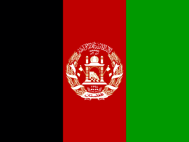
Three equal vertical bands of black (left), red, and green, with the national emblem in white centered on the red band and slightly overlapping the other bands; the emblem shows a mosque with a pulpit and flags on either side; below the mosque are Eastern Arabic numerals for the solar year 1298 (1919 in the Gregorian calendar, the year of Afghan independence from the UK); a border of wheat sheaves circles the mosque; above the mosque is an Arabic inscription of the Shahada (Muslim creed), with rays of the rising sun over the Takbir (Arabic expression meaning "God is great"); under the mosque is a scroll with the name Afghanistan.
What it means
Black stands for the past, and red for the blood shed for independence; green can represent hope for the future, agricultural prosperity, or Islam.
"Milli Surood" (National Anthem) Abdul Bari Jahani/Babrak Wasa
National day
previous: Independence Day, 19 August (1919); under the Taliban Government, 15 August (2022) is declared a national holiday, marking the anniversary of the victory of the Afghan jihad
Independence
19 August 1919 (from UK control over Afghan foreign affairs)
Flag description and meaning, colours, symbols, anthem details, national day and independence: CIA World Factbook (public domain). Coat of arms, motto and recording: Wikidata and Wikimedia Commons (credited above). Flag artwork: flag-icons (MIT), retrieved 1 November 2026.
Sites, years and types: the UNESCO World Heritage List via Wikidata, retrieved 1 November 2026; ordered by year listed. Names link to English Wikipedia, or to the UNESCO page when there is no article.
The Landlore · 1388 words · 7 min read · Reviewed 2026-11-08
Water crosses the mountains; the country does not move as one
Afghanistan is landlocked, but its rivers do not stay within its borders. Snow and ice gather high in the Hindu Kush and Pamir ranges; their melt feeds the Amu Darya toward Central Asia, the Kabul River toward the Indus, and the Helmand across the southwest. Those waters connect Afghan valleys to distant basins, while the mountains between them can make a journey from one part of the country to another slow and difficult. To understand Afghanistan, start with this tension: a land built by movement and exchange, yet divided by terrain, distance and political power.[1][2][3]
From the International Space Station, snow and ice trace the high ranges of the Hindu Kush around Kuh-e Bandaka and the Kokcha River. Photo: Earth Science and Remote Sensing Unit, NASA Johnson Space Center / Wikimedia Commons · Public Domain
The map is not a single mountain wall. North of the Hindu Kush lie broad plains and routes toward the Amu Darya. Central highlands rise into the Hazarajat, a region with many Hazara communities, where Bamyan sits in a high valley. Kabul occupies a basin east of the central ranges; Kandahar opens toward the dry south, while Herat faces west toward Iran and the routes of Khorasan. In the southwest, the Helmand River runs through an arid plateau before reaching the Sistan basin shared with Iran. The names are familiar from headlines, but each points to a distinct landscape and local history.[1][4][16]
This geography gives Afghanistan neither a single climate nor one way of making a living. Elevation changes the length of winter, the timing of planting and the roads that remain open. In some valleys, irrigation turns river water into orchards and fields; elsewhere, pastoral livelihoods depend on moving animals between seasonal pasture. Water scarcity and drought can narrow those choices. When snowpack melts early or river flows fall, the effect can travel from a high catchment to a village canal, a harvest and a household’s ability to stay.[4][5]
Everyday life shaped by season and distance
In rural Afghanistan, farming and herding remain tied to water, land access and season. Wheat is a staple crop across both irrigated valleys and rain-fed northern plains; pomegranates, grapes, almonds, pistachios, melons and vegetables vary by elevation and water supply. Traditional underground irrigation channels known as karez, along with surface river canals, are maintained through shared village labor, while a damaged intake or a dry year can affect several settlements downstream. In 2026, the Food and Agriculture Organization reported the restoration of an irrigation intake serving six villages in Logar, illustrating how a single piece of shared infrastructure supports hundreds of hectares and many rural households.[4][5]
Irrigated fields cross the floor of the high Bamyan Valley beneath the cliffs and ranges of the central highlands. Photo: Monikajoannah / Wikimedia Commons · CC BY-SA 4.0
That local dependence sits inside a national economy under strain. Agriculture supports many livelihoods, but drought, weak purchasing power and limited infrastructure constrain production. The World Bank describes recent economic growth alongside deep poverty, high unemployment, declining external aid and barriers to women’s participation. UNDP’s recent assessments also point to the pressure created by climate shocks, return migration and restrictions on women’s rights. These are not abstract indicators: they shape whether a family can afford food, whether a young person can find work, and whether people who left can rebuild a life after returning.[13][14]
Movement is part of the country’s ordinary story as well as its political one. People travel to provincial markets, to Kabul for education or work, across borders for trade and family, or between highland and lowland pasture. UNHCR recorded about 5.4 million Afghan return movements from neighboring countries since late 2023; many people had lived abroad for years, and some were forced back in difficult circumstances. Return can mean reunion, but it can also mean arriving in a place with scarce housing, work and services. “Home” is therefore not a simple point on a map for everyone.[13][14]
Kabul is the capital and a major center of national administration, commerce, universities and media. It draws people from across the country, and its neighborhoods contain different languages, class positions and migration histories. But Kabul is not a shorthand for Afghanistan. A resident of the capital may experience the country through office work, schooling and transport; a herder in the highlands, a farmer near the Helmand or a shopkeeper in Herat may have a different relationship to distance, public services and the state. The cities of Kabul, Herat and Kandahar each connect their surrounding regions to wider networks in distinct ways.[17]
Bread, rice and the work of welcome
Afghan food is not one fixed menu. Bread, tea, rice, vegetables, meat and dairy appear in combinations shaped by household means, region and occasion. Nān, often translated simply as bread, can be baked in forms that vary by place and oven; the word is also used broadly for food in Dari and neighboring Persian-speaking traditions. Green or black tea may accompany a meal or a visit. These are everyday anchors, but the food available to a family depends on harvests, prices and access, especially during periods of drought or economic hardship.[15]
On a celebratory table, a rice dish such as qabili palaw may bring together long-grain rice, carrots, raisins and meat, while dumplings such as mantu or aushak take more time to prepare and share. Across the country, seasonal preservation also shapes the pantry: households dry mulberries, apricots, raisins and curd such as qurut so winter meals still carry the harvests of summer orchards and highland pastures. Their ingredients and names shift across homes and regions. Hospitality holds weight in many Afghan communities, and it works as a practice of hosting and reciprocal care rather than a cliché about national temperament. A meal can welcome a guest while also carrying the labor of shopping, cooking and serving—work often assigned unevenly within families.[15]
Afghan craft and art show the same combination of local skill and exchange. Carpet weaving, embroidery, metalwork, woodcarving, glazed tilework, calligraphy and music have developed through regional traditions and changing markets. Bamyan’s contemporary craft initiatives, for example, connect heritage to income and community participation. UNESCO describes a carpet-weaving project there that employs local women and people from vulnerable communities, linking wool preparation, natural dyeing and loom work to household earnings. Such work adapts with the materials, customers and opportunities available today. A craft persists through access to training, household time and markets, and through the income makers can earn from their skill.[8]
Atlas Inquiry: key geographic and cultural questions
Why does the Wakhan Corridor exist as a narrow strip of land?
The Wakhan Corridor was established in 1893 during the diplomatic demarcation known as the Great Game between the British and Russian empires. Both powers sought a neutral buffer to prevent Russian Central Asia from directly touching British India. Running eastward between the Pamir and Karakoram ranges to the border with China, the narrow strip of high-altitude valleys ensured the two rival imperial spheres remained separated by Afghan territory. Today it remains sparsely populated by Wakhi pastoralists and Kyrgyz nomads grazing yaks.
How do traditional underground irrigation channels function across Afghan valleys?
Known locally as karez, these ancient underground aqueducts tap groundwater from alluvial aquifers at the bases of mountains and transport it downhill using gravity alone. Subterranean tunnels prevent evaporative loss across scorching summer deserts and deliver water directly to terraced agricultural plots. Vertical maintenance shafts puncture the ground every few dozen metres to supply ventilation and access for excavators. Communities organize shared cleaning rotas and water allocation rosters through hereditary canal overseers known as mirabs to maintain equitable distribution.
What languages dominate everyday communication across the provinces?
Dari, an eastern variant of Persian, and Pashto serve as the two official languages of the state. Dari functions as the lingua franca of administration, high literature, and commerce across urban centers, while Pashto dominates across southern and eastern tribal districts. Northern river plains also host Uzbek and Turkmen speakers, while remote central highlands preserve Hazaragi, an eastern Persian dialect with Mongolian lexical influences. Multilingualism is ordinary across major transport corridors, where merchants negotiate fluently in multiple regional idioms.
Why did the ancient Silk Road route pass through northern Afghan oases?
The fertile oases along the northern foothills of the Hindu Kush provided dependable water, fodder, and caravan staging posts between the Taklamakan Desert and the Iranian plateau. Cities such as Balkh, known in antiquity as Bactra, prospered because merchants travelling along Eurasian overland routes had to resupply before crossing treacherous alpine passes. This strategic geography fostered a remarkable meeting of Greek, Persian, Indian, and Chinese goods, ideas, artistic styles, and Buddhist monastic institutions for several centuries.
Last fact review: 2026-11-08 · Sources checked manually; facts are not automatically updated.
Image credits
Photo: Mark Ray / Wikimedia Commons (resized) ↗Image licencePublic domainPhotograph by Mark Ray / Wikimedia Commons (resized). Display crop may differ from the original.
We are building an open, source-backed atlas of every country, region, ocean and culture — combining verified geographic data with long-form cultural storytelling.
Names and immediate parent assignments: GeoNames, CC BY 4.0, 28 October 2026. Unspecified code 00 excluded. This is not an exhaustive list of districts, counties or municipalities. Photographs are credited individually beneath each image; one pictured place does not represent every landscape in its region.
FROM THE JOURNAL
Stories from Afghanistan
Our editorial journey here is still ahead. No researched stories have been published for this place yet.












Share what you know
Been there, grew up there, or know something we missed? Add a comment; corrections with a source are especially welcome.