Belize sits between the Caribbean reef and the forested Maya uplands. Follow its rivers inland to see how Maya histories, timber colonialism, many languages and a modern national border shape life across this small Central American country.
Neighbours from Wikidata (land borders and some sea borders; only places with a page here).
FLAG & SYMBOLS
The flag and symbols of Belize
The flag
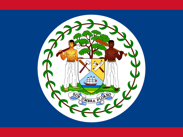
Royal blue with a narrow red stripe along the top and the bottom edges; the coat of arms is on a large white disk at the center and shows a shield flanked by two workers in front of a mahogany tree, with the motto Sub Umbra Floreo (I Flourish in the Shade) on a scroll at the bottom; a green garland of 50 mahogany leaves rings the coat of arms.
What it means
The figures, the mahogany tree, and the garland refer to the logging industry that led the British to settle Belize; blue and red are the colors of the two main political parties.
Battle of St. George's Caye Day (National Day), 10 September (1798); Independence Day, 21 September (1981)
Independence
21 September 1981 (from the UK)
Flag description and meaning, colours, symbols, anthem details, national day and independence: CIA World Factbook (public domain). Coat of arms, motto and recording: Wikidata and Wikimedia Commons (credited above). Flag artwork: flag-icons (MIT), retrieved 1 November 2026.
Sites, years and types: the UNESCO World Heritage List via Wikidata, retrieved 1 November 2026; ordered by year listed. Names link to English Wikipedia, or to the UNESCO page when there is no article.
The Landlore · 1848 words · 9 min read · Reviewed 2026-11-02
The reef is only the beginning
Belize’s barrier reef is not one line of coral that can be taken in at a glance. The UNESCO-listed Belize Barrier Reef Reserve System is a group of seven protected areas, joining reef, atolls, sandy cays, mangroves, lagoons and estuaries along the Caribbean coast. The system is famous for what lies offshore, but its story keeps moving inland. Rivers bring water and sediment down from the Maya Mountains; forest shelters archaeological cities; farms and towns follow the corridors between them. Belize becomes easier to understand when the sea is treated as a beginning rather than a border.[1]
Offshore at Lighthouse Reef, the Great Blue Hole forms part of the seven protected marine areas in the Belize Barrier Reef Reserve System. Photo: The TerraMar Project / Wikimedia Commons · CC BY 2.0
Belize is on the Caribbean coast of Central America, between Mexico and Guatemala. It is the only Central American country with English as its official language, a legacy of British rule. Its geography, family histories and daily speech also connect it to Spanish-speaking neighbours and to the Caribbean. The reef makes one map, but the mainland makes another: low northern plains, river valleys through the centre, and forested hills rising in the south. These are not separate worlds. Water, work, migration and memory have kept them in contact.[2][3]
English on paper, many languages in daily life
English is Belize’s official language, but the 2022 census recorded a far more layered soundscape. English, Spanish and Belizean Kriol were widely spoken, and people could report more than one language. Mopan, Q’eqchi’ and Yucatec Maya, Garifuna, German and other languages also appear in the country’s language map. The proportions and languages vary by district: Spanish is prominent in the north, Kriol in parts of the central and southern coast, and Maya languages in Toledo. These are broad patterns rather than rules for every conversation or family.[12]
Belizean Kriol is an English-based creole with its own grammar, vocabulary and expressive range. Calling it simply informal English would miss its history and its place in everyday communication. English is important in government and education; Kriol circulates across communities, while Spanish is a first language for many Belizeans and a link to regional neighbours. For visitors, this means a country can feel familiar in one setting and shift language in the next. For residents, multilingual life can be a practical resource, a marker of belonging and a reminder that the country’s history was never only British.[12][13]
Belize’s 2022 census records Creole, Mestizo, Maya, Garifuna, East Indian, Mennonite, Chinese and other identities. The categories do not tell us which language a person speaks or how they understand their own family history. No one group can stand for all Belizeans. A newcomer begins to see the country more clearly by following the connections among them: through the towns where people trade, the rivers and roads that link districts, and the languages used to make a life in different places.[12]
Belize’s small population is spread across six districts, with Belize City, Belmopan and San Ignacio serving very different roles. The coast and cayes orient much of the visitor’s mental map, while inland district towns connect farms, schools, government offices and markets to rural communities. Distance is not measured only in kilometres: river crossings, road conditions, rainy-season flooding and the availability of transport can shape how easily people reach services or sell produce. The national scale is compact, but daily life is not uniform or frictionless.[5][12]
Timber, slavery and the making of a colony
The forest that now draws ecologists and travellers was once the source of the British settlement’s wealth. English-speaking settlers extracted logwood for its dye and later cut mahogany for export. Timber could be reached through rivers and worked in forest camps, so the colonial economy developed differently from the sugar plantations of many Caribbean islands. That difference should not soften the violence of the system: enslaved Africans were forced to cut and haul timber, separated from families for long periods, and subjected to law and control designed to protect settlers’ power.[19][20]
Some early settlers governed their affairs through local assemblies while Britain and Spain contested authority over the territory. In the nineteenth century, Britain tightened its control, and the settlement became the Crown Colony of British Honduras in 1862. The name Belize replaced British Honduras in 1973. That change came amid a long struggle for self-government and a dispute with Guatemala over territory. Belize became independent on 21 September 1981; the legal and diplomatic dispute did not disappear with independence. Belize and Guatemala later agreed to submit Guatemala’s territorial, insular and maritime claim to the International Court of Justice, where it remains a matter for legal determination.[21][reference needed]
Belize’s communities have distinct histories of movement and belonging. Garifuna communities settled along the southern coast in the nineteenth century, and Garifuna Settlement Day remembers a particular history of arrival and community life.[14][15] In the north, many Mestizo families trace ancestry to refugees of the mid-nineteenth-century Caste War in Yucatán; the Library of Congress country study also records later migration from neighbouring Central American countries, especially during the 1980s.[23] These histories are not interchangeable, and movement does not erase the longer presence of Maya communities or the differences between Belize’s districts. They are part of a country whose borders and population have been shaped by both local continuity and connections across the region.[12][23]
Two cities and a country learning from storms
Belize City remains the country’s largest urban centre and main port; Belmopan is the capital, where national government is based. Their different roles are written into a decision made after Hurricane Hattie devastated the coastal capital in 1961. The government planned an inland capital on higher ground, and Belmopan became the seat of government in 1970. Belize City did not cease to matter. It remains a hub for commerce, transport and culture, while Belmopan expresses the idea that the state should not be concentrated on a vulnerable coast.[24][2]
Across Haulover Creek, the Swing Bridge links the working waterfront and commercial streets of Belize City. Photo: ironypoisoning / Wikimedia Commons · CC BY-SA 2.0
Storms still shape choices about housing, roads, farming, tourism and coastal development. Belize’s updated climate plan describes risks to fisheries and agriculture as well as the reef, with changing rainfall, sea-level rise and severe storms affecting people and ecosystems. The risk is not shared evenly: a coastal fishing village, an inland farm and a city neighbourhood face different hazards and have different resources for recovery. A plan for resilience has to address those differences, not treat the whole country as one shoreline.[7][26]
Food makes the country’s connections tangible. Rice and beans with stewed chicken is widely described as a national plate, and it sits beside foods that tell other local stories: corn tortillas and recado in Maya kitchens; hudut, a Garifuna dish of fish served with mashed plantain in coconut broth; cassava, seafood and seasonal produce along the coast. These foods overlap through ingredients and trade, but they are not one menu. Who cooks them, where a meal is shared and which language is used around the table all vary with family, community and place.[reference needed]
Religion and belief are part of this varied social landscape, but neither can be treated as a single national character. Christian churches have a visible place in many communities, while Maya and Garifuna knowledge and ceremony carry their own histories and meanings. The important point for a visitor is not to sort people into labels, but to recognize that public holidays, family practices, music and community obligations may draw on different traditions, sometimes within the same town or family. Belonging here is layered, and people decide how those layers matter in their own lives.[13][14]
Belize’s economy draws on tourism, agriculture, fisheries, forestry, services and remittances, and its small scale makes it responsive to markets and storms beyond its borders. Tourism brings visitors to reefs, caves and Maya sites; agricultural exports connect farms to foreign buyers; family remittances link household budgets to work abroad. These sectors meet in the same landscapes, which means growth can create jobs and at the same time increase pressure on water, forest or coast. The choices are specific: what to build, whose land is involved, what livelihoods a protected area supports, and which costs are carried by communities over time.[reference needed][reference needed]
Begin with the seven protected reef sites and Belize may look like a country defined by the sea. Follow its rivers toward Caracol, through the towns of the centre, and onward to Belmopan or the forests of Toledo, and the first image changes. Belize is a mainland country whose Caribbean coast opens into a wide network of human and natural connections. Its people have lived through the making of Maya cities, a timber colony built on enslaved labour, migrations from surrounding regions and the long task of turning British Honduras into an independent state. Its living communities keep revising what those inheritances mean. The reef does not conclude Belize’s story; it is where one of its many routes begins.[1][5][21]
Atlas Inquiry: key geographic and cultural questions
What geological forces created the submarine Great Blue Hole?
The Great Blue Hole began forming as an inland karst cave system during multiple episodes of Quaternary glaciation, when ocean levels were significantly lower. Percolating rainwater dissolved the limestone bedrock, carving cavernous chambers with massive stalactites and stalagmites. When global temperatures rose and glaciers melted, rising oceanic waters flooded the cavern network. The weight of the seawater eventually caused the weakened limestone ceiling to collapse inward, creating a circular marine sinkhole that plunges over 120 metres into turquoise reef waters.
How did the Maya utilize caves such as Actun Tunichil Muknal for ritual purposes?
Ancient Maya civilization viewed limestone caves as portals to Xibalba, the subterranean underworld inhabited by rain deities like Chaac and lords of death. During periods of severe drought in the Late Classic era, Maya priests and shamans ventured deep into darkness, wading through subterranean rivers to reach remote chambers like Actun Tunichil Muknal. There they offered ceramic vessels, bloodletting sacrifices, and human victims to appease the gods of fertility. Water dripping over centuries encased these sacrificial remains in sparkling calcite crystals.
Who are the Garifuna and how did they arrive on the southern coast?
The Garifuna are an Afro-indigenous people descended from West Africans who survived shipwrecked slave ships and intermarried with indigenous Arawak and Island Carib populations on the Caribbean island of Saint Vincent. After British forces defeated their resistance in 1797, thousands were forcibly deported to Roatán island off Honduras. From there, Garifuna families migrated along the Central American coastline, establishing fishing villages like Dangriga and Punta Gorda. They preserved their distinct Arawakan-based language, ancestral drumming rituals, cassava bread traditions, and communal social customs.
Why is English the official language in a Spanish-speaking region?
Unlike its Central American neighbors colonized by the Spanish Empire, Belize was colonized by British buccaneers and woodcutters known as the Baymen in the seventeenth century. These settlers exploited valuable logwood and mahogany stands along coastal rivers, defending their territorial settlements against Spanish raids with British naval support. In 1862, the territory was formally designated the crown colony of British Honduras, embedding English law, governance, and administration. Today, while English remains the official tongue, everyday communication incorporates Belizean Kriol and Spanish.
We are building an open, source-backed atlas of every country, region, ocean and culture — combining verified geographic data with long-form cultural storytelling.
Names and immediate parent assignments: GeoNames, CC BY 4.0, 28 October 2026. Unspecified code 00 excluded. This is not an exhaustive list of districts, counties or municipalities. Photographs are credited individually beneath each image; one pictured place does not represent every landscape in its region.
FROM THE JOURNAL
Stories from Belize
Our editorial journey here is still ahead. No researched stories have been published for this place yet.










Share what you know
Been there, grew up there, or know something we missed? Add a comment; corrections with a source are especially welcome.