




Cradled in the southern African interior between two of the continent’s legendary waterways—the thundering Zambezi River to the north and the sluggish, sand-choked Limpopo River to the south—the Republic of Zimbabwe is a nation of monumental stone architecture, rich geological formations, and extraordinary wildlife sanctuaries. Spanning 390,757 square kilometers, this landlocked country is bordered by Zambia to the north, Mozambique to the east, South Africa to the south, and Botswana to the southwest, touching Namibia at a narrow western river quadripoint. Most of the country rests upon the Highveld, an elevated central plateau soaring between twelve hundred and sixteen hundred meters above sea level, enjoying a temperate subtropical climate that nurtures fertile agricultural soils and extensive woodlands before descending into the hot, arid savannah lowlands of the Lowveld.
Zimbabwe is distinctive among the nations of the world in that it derives its sovereign name directly from a pre-colonial architectural masterwork: Dzimba-dza-mabwe, meaning “Venerated Houses of Stone” in the indigenous Shona language. The human geography of Zimbabwe is anchored by the Shona people, who comprise approximately eighty percent of the population, alongside the Ndebele people of the southwest and smaller Shangani, Venda, Tonga, and European communities. This historical landscape is distinguished by centuries of indigenous metallurgical mastery, celebrated stone sculpture recognized in major art museums worldwide, the resonant spiritual polyphony of the mbira dzaVadzimu (thumb piano), and an enduring national pride that weathered nineteenth-century British colonial dispossession under Cecil Rhodes to achieve national liberation in 1980.
Citadel of Stone: The Architectural Genius of Great Zimbabwe
Thirty kilometers southeast of the modern city of Masvingo, rising majestically among granite kopjes and lush miombo woodland, stands the greatest archaeological monument in sub-Saharan Africa: Great Zimbabwe. Spanning nearly eight hundred hectares, this monumental stone city was the imperial capital of the Kingdom of Zimbabwe between the eleventh and fifteenth centuries, supporting a thriving urban population of over eighteen thousand citizens at its peak.
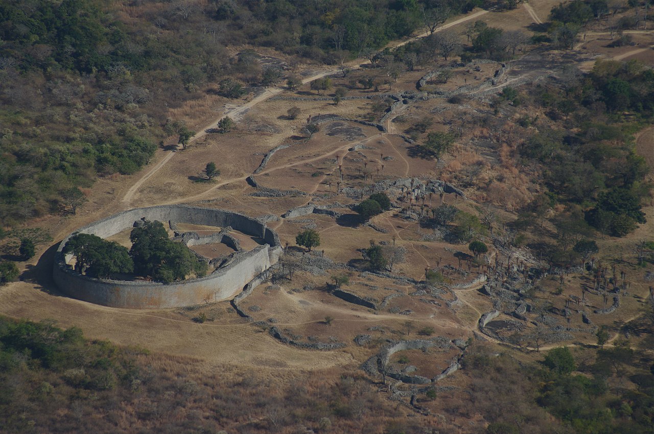
What elevates Great Zimbabwe into the highest ranks of world architectural heritage is its dry-stone masonry. The massive curvilinear walls—some reaching eleven meters in height and extending for hundreds of meters—were constructed entirely from trimmed, rectangular granite blocks fitted together with precision without a single drop of mortar. Master builders split granite boulders using thermal fracturing (heating stone with wood fires and cooling it rapidly with water), carefully dressing the granite into uniform ashlar blocks and laying them in graceful, inward-sloping batter walls to ensure structural stability against earthquakes and tropical storms.
The ruins comprise three primary architectural complexes: the Hill Complex, a fortified cliff-top acropolis incorporating massive natural granite boulders into sheer defensive walls; the Valley Ruins, clusters of residential family compounds; and the Great Enclosure. The Great Enclosure is the largest ancient single structure south of the Sahara, encircled by an outer wall over two hundred and fifty meters long composed of roughly one million dressed granite stones. Inside stands the Conical Tower, a solid stone cylinder ten meters high whose precise symbolic function—whether a grain silo symbolizing royal generosity or a phallic spiritual monument—remains one of the captivating enigmas of African archaeology.
Great Zimbabwe was the hub of an expansive global trading network. Archaeological excavations have unearthed Chinese Ming dynasty celadon porcelain, Persian cobalt glassware, and glass beads from the Indian Ocean coast, traded for raw alluvial gold, elephant ivory, and copper mined in the interior. It was here that archaeologists recovered the eight iconic carved soapstone figures of the Zimbabwe Bird (Hungwe), blending human and avian raptor features, which now serve as the sovereign national emblem of the republic, featured on the national flag, banknotes, and coat of arms.
The Sacred Granite Sanctuaries of the Matobo Hills
South of the industrial city of Bulawayo lies the Matobo Hills, designated a UNESCO World Heritage site in 2003. Formed over two billion years ago through tectonic uplift and continuous chemical and physical weathering of an ancient granite batholith, Matobo presents a surreal geological wonderland of smooth granite domes (known locally as dwalas or “whalebacks”) and precariously balanced granite boulders (kopjes) perched like giant marbles atop weathered rock surfaces.

The Matobo Hills have been revered as a sacred spiritual landscape for thousands of years. Within hundreds of granite rock shelters and hidden caves lies one of the highest concentrations of prehistoric rock art in southern Africa, painted by ancestral San hunter-gatherers between two thousand and thirteen thousand years ago. Using natural pigments of red iron ochre, charcoal, and kaolin clay mixed with animal fat and blood, San artists created exquisite naturalistic depictions of giraffes, rhinos, kudus, and human spiritual trance dances, illustrating a sophisticated cosmological worldview deeply attuned to the natural landscape.
In later centuries, the Shona and Ndebele peoples established sacred spiritual shrines throughout the hills, most notably the Njelele shrine, where oracles of the high god Mwari have been consulted for rainmaking ceremonies and guidance during times of national drought or conflict. The hills also contain the historic burial site of Ndebele king Mzilikazi, and atop the summit of Malindidzimu (“The Hill of the Spirits”)—controversially renamed “World’s View” by British imperialist Cecil John Rhodes—sits Rhodes’s own bronze-plated tomb, carved directly into the solid granite bedrock, overlooking a panoramic sea of rolling granite kopjes.
The Garden of the Zambezi: Mana Pools National Park
Along the lower Zambezi River, facing Zambia across the wide river channel, lies Mana Pools National Park, inscribed as a UNESCO World Heritage site in 1984. The word mana means “four” in the Shona language, referring to the four large permanent oxbow lakes—Chine, Chisuwe, Long Pool, and Mulape—carved by the meandering Zambezi across the broad alluvial floodplain.

Mana Pools is celebrated as one of the most sublime and pristine wildlife ecosystems on Earth. The floodplain is dominated by magnificent, open cathedral-like woodlands of giant winterthorn trees (Faidherbia albida), whose protein-rich seed pods ripen and drop during the dry season from July to October, precisely when all other vegetation has desiccated. This botanical blessing draws colossal herds of African elephants, buffaloes, elands, and waterbucks into the shaded glades. Here, famous elephant bulls have learned a remarkable behavioral adaptation: standing upright on their hind legs and extending their trunks high into the canopy to pluck coveted pods from the upper branches.
Mana Pools is one of the few national parks in Africa where visitors are permitted to walk unguided through the wild terrain, accompanied by the legendary professional guides of Zimbabwe, who undergo the most rigorous four-year qualification apprenticeship on the continent. Walking quietly through the golden sunlight beneath the albida trees reveals packs of endangered African wild dogs hunting impalas, prides of lions resting in river sandbanks, and over three hundred and eighty species of birds, providing an unforgettable experience of unscripted wilderness.
Elephant Kingdom of Hwange and Kariba Inland Waters
Sprawled across fourteen thousand six hundred square kilometers along the western border with Botswana, on the eastern boundary of the Kalahari Desert sands, lies Hwange National Park—Zimbabwe’s premier and largest wildlife reserve. Formerly the royal hunting grounds of the Ndebele king Mzilikazi in the nineteenth century, Hwange is celebrated across the globe as the ‘Kingdom of the Elephants.’ The park supports an estimated forty-five thousand to fifty thousand African bush elephants—one of the densest and largest elephant concentrations on Earth—alongside more than one hundred mammal species and four hundred bird species.
Because Hwange possesses no major perennial rivers, its vast herds of elephants, buffalo, and endangered roan and sable antelopes are sustained by an extraordinary network of over seventy artificial, diesel- and solar-powered boreholes. Engineered in the 1930s by pioneering conservationist Ted Davison, these waterholes pump life-saving water from deep underground Kalahari aquifers into surface pans during the brutal dry season, creating epic congregations where hundreds of elephants jostle for drinking space alongside prides of lions and packs of African wild dogs under the golden dust of the African afternoon.
Along the northern frontier with Zambia, the Zambezi River expands into Lake Kariba, one of the world’s largest human-made reservoirs by volume, spanning five thousand five hundred square kilometers. Formed between 1955 and 1959 by the construction of the colossal double-curvature concrete arch of Kariba Dam—designed by French civil engineer André Coyne—the flooding of the Gwembe Valley displaced fifty-seven thousand Tonga people and necessitated ‘Operation Noah,’ a legendary rescue mission led by Rupert Fothergill that rescued over six thousand wild animals from rising floodwaters. Today, Kariba’s flooded mopane tree skeletons pierce the surface of the lake, forming haunting silhouettes against fiery orange sunsets, while supporting a thriving night-time commercial fishery for freshwater sardine (kapenta), whose harvest rigs light up the nocturnal waters like floating constellations.
The Mist-Clad Heights of the Eastern Highlands
In striking contrast to the hot savannah plains of Hwange and Kariba, Zimbabwe’s eastern border with Mozambique rises into the cool, mist-cloaked peaks of the Eastern Highlands. Stretching three hundred kilometers from north to south, this mountain chain encompasses three distinct natural regions: the rolling montane grasslands and trout streams of the Nyanga range in the north, the lush botanical cloud forests of the Bvumba Mountains in the center, and the dramatic, jagged quartzite crags of the Chimanimani Mountains in the south.
In Nyanga National Park, Mount Nyangani rises to 2,592 meters as the highest summit in Zimbabwe, surrounded by ancient stone agricultural terraces, pit structures, and iron smelting furnaces dating back to fourteenth-century Shona civilizations. Nearby, the Mutarazi Falls plunge 762 meters down a sheer amphitheater into the Honde Valley, ranking as the second-highest waterfall in Africa. In the fertile microclimates of the Honde and Chipinge valleys, mist-fed plantations produce premium tea, macadamia nuts, and specialty highland coffee, illustrating the astonishing agricultural and ecological diversity that defines this southern African nation.
The Mbira, Shona Sculpture, and Cultural Resilience
Zimbabwe’s artistic soul is defined by two world-renowned cultural traditions: Shona stone sculpture and the sacred music of the mbira. Beginning in the late 1950s at the Tengenenge sculpture community and the National Gallery of Zimbabwe under Frank McEwen, master sculptors such as Nicholas Mukomberanwa, Henry Munyaradzi, and Bernard Matemera gained international acclaim. Working directly with local hard serpentine, springstone, and verdite stones, these artists sculpt elegant, stylized human and mythological figures that reveal the spiritual essences believed to reside within the stone itself.
Equally deep is the music of the mbira dzaVadzimu, an ancient acoustic instrument consisting of twenty-two to twenty-eight tuned forged iron keys mounted on a hardwood soundboard (gwariva), played inside a hollowed calabash gourd resonator (deze). During sacred bira ceremonies, master musicians pluck the metal keys with their thumbs and forefingers, accompanied by the rattle of dried bottle gourds (hosho) and interlocking vocal poetry. The intricate, cycling polyrhythms of the mbira induce spiritual trances, allowing community elders to communicate directly with ancestral spirits (Vadzimu) to seek guidance, rain, and communal healing. In the 1970s, musical legends like Thomas Mapfumo adapted traditional mbira rhythms to modern electric guitars, creating Chimurenga (“Struggle”) music, which served as the revolutionary soundtrack to national independence.
Agricultural Transition, Mineral Riches, and the Path Forward
Zimbabwe is blessed with exceptional agricultural and mineral foundations. Historically celebrated as the breadbasket of southern Africa, its fertile soils produce high-grade flue-cured Virginia tobacco, cotton, horticultural roses, macadamia nuts, and citrus for export, while smallholder farmers cultivate maize and drought-resistant small grains (sorghum and pearl millet) across the rural districts.
Geologically, Zimbabwe straddles the Great Dyke, a remarkable 550-kilometer-long layered igneous intrusion that cuts north-south across the center of the country. The Great Dyke contains the world’s second-largest known reserves of platinum group metals (PGMs) after South Africa, alongside colossal deposits of high-grade chromium, nickel, and gold. In recent years, Zimbabwe has emerged as a key global supplier of lithium, driven by massive hard-rock pegmatite deposits such as the Bikita and Arcadia mines, positioning the nation at the center of the global electric vehicle and battery storage transition.
Blended with the monumental architectural pride of Great Zimbabwe, sanctified by the ancient rock art of Matobo, and blessed with the pristine riverine wilderness of Mana Pools and Victoria Falls, Zimbabwe moves forward with cultural resilience, rich natural wealth, and deep historical dignity. In the low-lying southeastern Lowveld, Gonarezhou National Park (‘Place of Many Elephants’) preserves spectacular red sandstone cliffs at Chilojo, rising one hundred and eighty meters above the Runde River, forming a crucial component of the Great Limpopo Transfrontier Park linking Zimbabwe, South Africa, and Mozambique.








Share what you know
Been there, grew up there, or know something we missed? Add a comment; corrections with a source are especially welcome.