
Adria Microplate Tectonics and Asymmetric Bathymetry
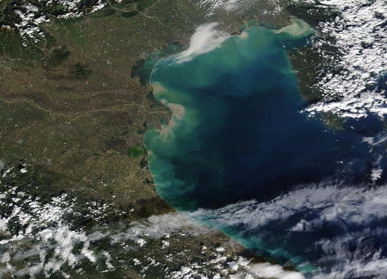
The Adriatic Sea is an elongated, semi-enclosed marginal sea of the central Mediterranean, extending approximately eight hundred kilometers from the Gulf of Venice and the low alluvial plains of Friuli in the northwest to the narrow portal of the Strait of Otranto in the southeast. Covering an area of roughly 138,000 square kilometers, the sea is bounded by the Italian peninsula to the west and the Balkan coastlines of Slovenia, Croatia, Bosnia and Herzegovina, Montenegro, and Albania to the east. The basin exhibits a striking physical asymmetry: its western coast is a low, unbroken alluvial shoreline smoothed by river sediments, while its eastern flank presents a fractured, mountainous labyrinth of limestone headlands, deep sea sounds, and over 1,200 drowned karst islands known as the Dalmatian archipelago.
The structural foundation of the Adriatic is governed by the geodynamics of the Adria microplate, an ancient continental fragment of the African tectonic plate that was wedged into the Eurasian landmass during the Alpine orogeny. As Adria was compressed between converging continental giants, its borders buckled upward to form towering mountain chains: the Apennines flanking its western flank in Italy, the Southern Alps to the north, and the Dinaric Alps to the east. The Adriatic basin represents the unconsumed foreland core of this rigid microplate, slowly subducting beneath the Apennines in the west while colliding with the Dinarides in the east.
The bathymetry of the seabed is neatly divided into three distinct morphological realms that step downward from north to south. The Northern Adriatic is an extraordinarily shallow epicontinental platform, rarely exceeding thirty to thirty-five meters in depth, which slopes with an imperceptible gradient down toward the central basin. During the Last Glacial Maximum, when global sea levels were roughly 120 meters lower than today, this entire northern third was exposed as a fertile, river-crossed grassland plain connecting Italy and Istria. The ancestral Po River extended hundreds of kilometers southeastward across this exposed continental shelf, gathering tributary torrents from the drowned valleys of the Tagliamento, Isonzo, and Krka rivers before discharging into the central basin.
South of this shallow shelf, the seabed plunges into the Middle Adriatic, marked by the Jabuka Pit (also called the Pomo Pit), an enclosed bathymetric depression sinking to 270 meters. Passing over the shallow underwater rise of the Palagruža Sill, the seafloor drops precipitously into the Southern Adriatic Basin. Here lies an expansive circular abyssal depression—the South Adriatic Pit—which descends to a maximum depth of 1,233 meters before shelving upward toward the shallow Sill of Otranto (depth 800 meters), which connects the Adriatic to the deep Ionian Sea. Deep structural faults along the Albanian and Montenegrin margins plunge into this southern abyssal plain, generating powerful regional earthquakes like the catastrophic 1979 Montenegro seismic event that triggered localized tsunamis and coastal rockfalls across the southern fjords.
Bora Gales and Basin Circulation Systems

The hydrodynamic circulation of the Adriatic Sea is organized into a large-scale cyclonic (counter-clockwise) gyre driven by thermohaline gradients, wind forcing, and the Earth’s rotation. Water enters the basin from the Ionian Sea through the eastern side of the Strait of Otranto as a warm, highly saline boundary flow known as the Eastern Adriatic Current. This inflow travels northward along the intricate island channels of Albania, Montenegro, and Croatia, delivering Mediterranean heat and salinity toward the northern shelf. Reaching the Gulf of Venice, the current absorbs immense freshwater discharge from the Po River, turns sharply counter-clockwise, and surges southward along the Italian coast as the colder, fresher, nutrient-rich Western Adriatic Coastal Current before exiting through the western side of the Otranto Strait.
The primary catalyst for seasonal oceanographic transformation across the basin is the bora—a severe, dry katabatic wind that bursts out of the northeast during the winter months. Originating over the cold, high-pressure continental interior of central Europe, dense polar air is forced upward over the Dinaric Alps and plunges down steep mountain passes toward the warm sea. Funneling through coastal gaps like the Senj Gorge and the Trieste gap, the bora strikes the water with sudden, terrifying velocity, with gusts regularly exceeding two hundred kilometers per hour. The wind strips heat and water vapor from the sea surface, generating dense sea spray (spolverino) that obscures visibility and creates steep, short-period waves.
This violent heat extraction and surface evaporation in the shallow northern shelf causes water temperatures to drop below 10°C while sharply increasing salinity. The resulting water mass becomes exceptionally dense and sinks to the seafloor, forming North Adriatic Dense Water—the densest water mass generated in the entire Mediterranean basin. Driven by gravity, this cold, oxygen-saturated bottom water flows slowly southward like an underwater river, cascading into the Pomo Pit and continuing into the deep South Adriatic Pit, where it drives deep-sea ventilation.
Conversely, during autumn and spring, the basin is frequently lashed by the scirocco, a warm, humid southeasterly wind that blows straight up the elongated axis of the sea from North Africa. Dragging surface waters northward, the scirocco piles up sea levels in the shallow Gulf of Venice. When this meteorological storm surge coincides with regular astronomical spring tides, it triggers the celebrated acqua alta flooding that inundates the historic plazas and canals of Venice, challenging human engineering and coastal resilience.
Drowned Karst, Vruljas and Benthic Nurseries
The marine ecology of the Adriatic Sea is profoundly shaped by the contrasting geomorphology of its coastlines. Along the eastern shores of Croatia and Montenegro, the Dinaric karst landscape continues directly beneath the waves. Extensive limestone cave systems, sinkholes, and vertical fractures that were carved subaerially during Pleistocene low-sea-level stands are now drowned in seawater. One of the most extraordinary hydrological features of this drowned karst is the vrulja—massive submarine freshwater springs where underground river systems flowing through cavernous limestone mountains discharge directly into the sea floor.
At locations like the famous Vrulja Bay near Omiš and the Bay of Kotor, hundreds of cubic meters of cold, crystal-clear freshwater bubble up from underwater cave openings at depths of up to thirty meters. The lighter freshwater creates visible boiling domes on the sea surface, reducing local salinity and establishing localized thermal microclimates that support specialized cold-adapted estuarine communities. Surrounding these underwater springs, submerged limestone walls drop vertically into deep blue water, encrusted with brilliant yellow sea fans (Eunicella cavolini), purple gorgonians, and precious red coral (Corallium rubrum).
In the shallow northern third of the sea, the soft muddy and sandy substrates nourished by Po River sediments create an entirely different ecological paradise. The extensive, sunlit continental shelf functions as the primary overwintering and foraging nursery for loggerhead sea turtles (Caretta caretta) in the Mediterranean. Thousands of juvenile and sub-adult turtles congregate across the northern shelf during summer and autumn, diving to the shallow seabed to feed on rich beds of benthic crabs, sea snails, and bivalves.
The island channels of the Kvarner Gulf and the Kornati archipelago shelter a celebrated resident population of short-beaked common dolphins and Indo-Pacific bottlenose dolphins (Tursiops truncatus), studied for decades around the islands of Cres and Lošinj. In the deep abyssal darkness of the South Adriatic Pit, where water depths plunge beyond one thousand meters, recent deep-sea explorations have revealed cold-water coral reefs dominated by Lophelia pertusa and Madrepora oculata, alongside rare deep-sea bamboo corals that construct delicate calcium carbonate skeletons in complete darkness.
Illyrian Galleys and the Republic of Venice
Human maritime engagement in the Adriatic Sea represents one of the richest tapestries of nautical history in the Mediterranean. Since the early first millennium BCE, the eastern karst coast was dominated by fierce Illyrian maritime tribes, notably the Liburnians and the Ardiaei. Masters of naval architecture, the Liburnians invented the liburna—a swift, lightweight wooden galley with two banks of oars that could maneuver with exceptional speed through the shallow, rocky island mazes of Dalmatia. These agile vessels were so effective at piracy and coastal raids that the Roman Navy adopted the liburnian hull design as the standard warship of the imperial Roman fleet following their victory over Queen Teuta in the Illyrian Wars.
Following the collapse of the Western Roman Empire, the marshy lagoons of the northern Adriatic provided an impenetrable refuge for Roman coastal populations fleeing Lombard and Hunnic invasions. In these shallow tidal mudflats, refugees drove millions of alder and oak timber pilings into the soft clay, founding the city of Venice. By the tenth century CE, Venice emerged as the Serenissima—the Most Serene Republic—whose entire political, commercial, and artistic life was intimately tied to mastery of the sea.
Every year on Ascension Day, the Doge of Venice sailed out to the Lido entrance aboard the magnificent golden state barge, the Bucintoro, to cast a consecrated gold ring into the waves, reciting the solemn declaration: We wed thee, sea, in token of true and lasting dominion. From their immense state shipyard, the Arsenale—which operated the world’s first industrial assembly line capable of producing a fully armed war galley in a single day—the Venetians projected naval power across the entire Adriatic, which imperial cartographers boldly labeled the Golfo di Venezia.
Venice established fortified naval ports and trading colonies along the entire Dalmatian coast, from Koper and Pula to Zadar, Šibenik, Split, and the fortified island fortress of Korčula. The sole independent rival that resisted Venetian hegemony was the maritime republic of Ragusa (modern Dubrovnik), whose skilled merchant navigators operated a formidable fleet of carracks that sailed the world, trading under the protective white flag of Saint Blaise and the motto Non bene pro toto libertas venditur auro (Liberty is not well sold for all the gold in the world).
During the sixteenth and seventeenth centuries, the strategic balance of the Adriatic was contested by the Ottoman Empire, whose expanding armies seized the Balkan hinterlands while Ottoman corsairs raided coastal shipping. In response, Christian irregular privateers known as the Uskoks established their fortress stronghold at Nehaj above the windswept coastal town of Senj, exploiting the fierce local bora gales to dart out in lightweight rowing barks, raiding Ottoman supply lines and Venetian merchantmen alike. In October 1571, the southern gateway of the sea formed the staging ground for the allied Christian Holy League fleet, which assembled in Adriatic ports before defeating the Ottoman naval armada at the monumental Battle of Lepanto, securing the maritime balance of the central Mediterranean for generations. For over five hundred years, the Adriatic served as the vital maritime umbilical cord linking the silk and spice routes of the Levant to the emerging markets of Renaissance Europe.
Acqua Alta, Eutrophication and the MOSE Era
In the twenty-first century, the Adriatic Sea faces compounding ecological and infrastructural challenges arising from its unique geography as an enclosed, shallow basin bordered by heavily industrialized and populated coastlines. The most globally visible symbol of this environmental confrontation is the threat posed by relative sea level rise and intensifying storm surges to the historic heritage of Venice. Over the past century, a combination of regional land subsidence caused by industrial groundwater extraction and eustatic sea level rise has lowered Venice by over twenty-five centimeters relative to the sea surface.
To defend the architectural wonders of the lagoon against catastrophic acqua alta floods, Italy undertook one of the most ambitious coastal engineering projects in human history: the MOSE system (Modulo Sperimentale Elettromeccanico). Comprising seventy-eight massive yellow steel barrier gates installed across the three inlets connecting the Venetian Lagoon to the open Adriatic—Lido, Malamocco, and Chioggia—the system lies submerged in seabed caissons during normal tides. When storm surges exceeding 110 centimeters are forecast, compressed air empties the gates of water, causing them to pivot upward within thirty minutes, sealing the lagoon and sheltering the historic city from oceanic waves.
Simultaneously, the shallow northern Adriatic continental shelf struggles with acute environmental degradation driven by agricultural and industrial runoff from the Po River basin. Over past decades, excessive inputs of synthetic nitrogen and phosphorus fertilizers have periodically triggered explosive summer algal blooms across hundreds of square kilometers. When these billions of microalgae die and sink to the shallow seabed, their bacterial decomposition consumes dissolved oxygen, creating widespread benthic hypoxia and devastating valuable commercial beds of native clams and crabs. In extreme summer heat, these nutrient excesses have historically spawned vast blankets of marine mucilage (mare sporco)—gelatinous organic slime that smothers coral reefs and clogs fishing nets.
To safeguard this shared marine heritage, Italy, Slovenia, and Croatia are increasingly pursuing coordinated trans-Adriatic marine governance. Integrated coastal zone management programs and the declaration of international marine protected areas—such as the Miramare Biosphere Reserve in Italy, the Strunjan marine park in Slovenia, and the Kornati and Mljet national parks in Croatia—are establishing strict no-take zones to restore depleted fish stocks and protect fragile Posidonia oceanica meadows. The Adriatic Sea remains an active, contested maritime highway where ancient nautical history and modern engineering innovation converge upon a fragile sea.
Frequently Asked Questions
How did the Adriatic Sea physically form?
The Adriatic Sea occupies an elongated depression formed by the ongoing tectonic indentation of the Adria (or Apulian) microplate between the colliding Eurasian and African plates. As the rigid continental promontory of Adria was thrust northward over the past sixty million years, its margins were compressed and folded into surrounding mountain belts: the Apennines of Italy along its western flank and the Dinaric Alps along its eastern flank. The basin’s floor is divided into three distinct morphological zones: a very shallow, gently shelving northern shelf (rarely exceeding thirty-five meters depth), a central bathymetric depression known as the Pomo or Jabuka Pit (plunging to 270 meters), and the deep South Adriatic Pit, which reaches a maximum depth of 1,233 meters before terminating at the shallow Sill of Otranto.
What causes the famous acqua alta tidal flooding in Venice?
Acqua alta (high water) in the Venetian Lagoon is caused by an unfortunate convergence of astronomical, meteorological, and oceanographic forces. When regular high astronomical tides coincide with sustained, gale-force southeasterly winds (the scirocco) blowing up the entire length of the elongated Adriatic Sea, water is pushed northward and piled up in the shallow northern gulf. This wind surge is exacerbated by low atmospheric pressure and basin-scale seiches—standing wave oscillations that bounce back and forth between the northern coast and the Strait of Otranto for up to twenty-two hours—trapping water inside the shallow lagoon.
What is the bora wind and how does it drive Adriatic oceanography?
The bora is a cold, violent, gusty katabatic wind that sweeps down from the cold interior of central and eastern Europe across the coastal ridges of the Dinaric Alps into the northern and eastern Adriatic Sea. Blowing most frequently from late autumn through winter, the dry, sub-zero air strips heat and moisture from the warm sea surface at tremendous rates. This extreme cooling and evaporation sharply increase the density of the surface water, causing it to sink to the seafloor as North Adriatic Dense Water. This dense water flows southward along the seabed, oxygenating deep marine pits and spilling out into the Ionian Sea.
How does the Po River influence the Adriatic marine environment?
The Po River is the largest fluvial tributary of the Adriatic, draining the snows and industrial heartland of the Italian Alps and the Po Valley. Discharging an average of 1,500 cubic meters of freshwater per second alongside millions of tons of sediment, the Po constructs an expansive bird-foot delta that projects into the northern sea. The river’s buoyant freshwater plume turns southward under the influence of the Coriolis force, hugging the Italian coastline and creating a productive coastal corridor rich in nutrients that sustains valuable anchovy, sardine, and mussel fisheries while periodically triggering summer algal blooms.





Share what you know
Been there, grew up there, or know something we missed? Add a comment; corrections with a source are especially welcome.