
Endorheic Heart of Central Asia and Ancient River Deltas

Spanning the sun-scorched, wind-scoured depression of the Turan Lowland between the sand seas of the Kyzylkum and Karakum deserts, the Aral Sea basin represents one of the most remarkable and tragic geographic landscapes on Earth. Geologically, the Aral depression is an endorheic terminal basin formed during the late Pliocene and Pleistocene epochs as tectonic subsidence created a vast enclosed hollow with no hydrological connection to the global ocean. For millennia, the existence of this inland sea was maintained by a delicate thermodynamic equilibrium: the torrential, snow-and-glacial-melt discharge of the two mighty river arteries of Central Asia—the Amu Darya (the ancient Oxus) flowing from the Pamir Mountains and the Syr Darya (the ancient Jaxartes) descending from the Tian Shan—balanced against the ferocious evaporation rates of the Central Asian desert summer.
In 1960, the Aral Sea was a blue oceanic oasis in the desert. Encompassing an area of sixty-eight thousand square kilometers, it measured four hundred and thirty-five kilometers from north to south and nearly three hundred kilometers from east to west. With a maximum depth of sixty-eight meters along its steep western cliff—the Ustyurt Plateau—and an average depth of sixteen meters across its gentle eastern shallows, the sea was populated by over fifteen hundred islands and islets, whose name in Turkic languages—Aral Dengizi, ‘the Sea of Islands’—gave the basin its identity. The broad delta wetlands of the Amu Darya in the south and the Syr Darya in the northeast were dense jungles of giant reeds (Phragmites australis) and tugay gallery forests, supporting abundant wild boar, Bukhara deer, and millions of migratory waterfowl traveling along the Central Asian Flyway.
The seabed of the historic Aral Sea supported an active commercial fishing industry centered in the major port cities of Aralsk in Kazakhstan and Moynaq in Uzbekistan. Fleets of steel fishing trawlers and wooden cutters harvested tens of thousands of metric tons of valuable commercial fish each year, including Aral barbel (Luciobarbus brachycephalus), bream, pikeperch, carp, and the endemic Aral salmon. Massive fish processing canneries in Moynaq and Aralsk operated twenty-four hours a day, packing millions of tins of smoked fish that were shipped via the Trans-Aral Railway to nourish cities across the Soviet Union. Archaeological surveys along the dry bed have revealed that the Aral Sea fluctuated naturally over deep geological time; during the medieval period between the tenth and fourteenth centuries, known as the Golden Horde drought, lowered lake levels exposed ancient settlements and mausoleums, most notably the Kerderi complex, before returning river flows reflooded the basin for centuries.
Soviet Cotton Engineering and the Great Water Diversion
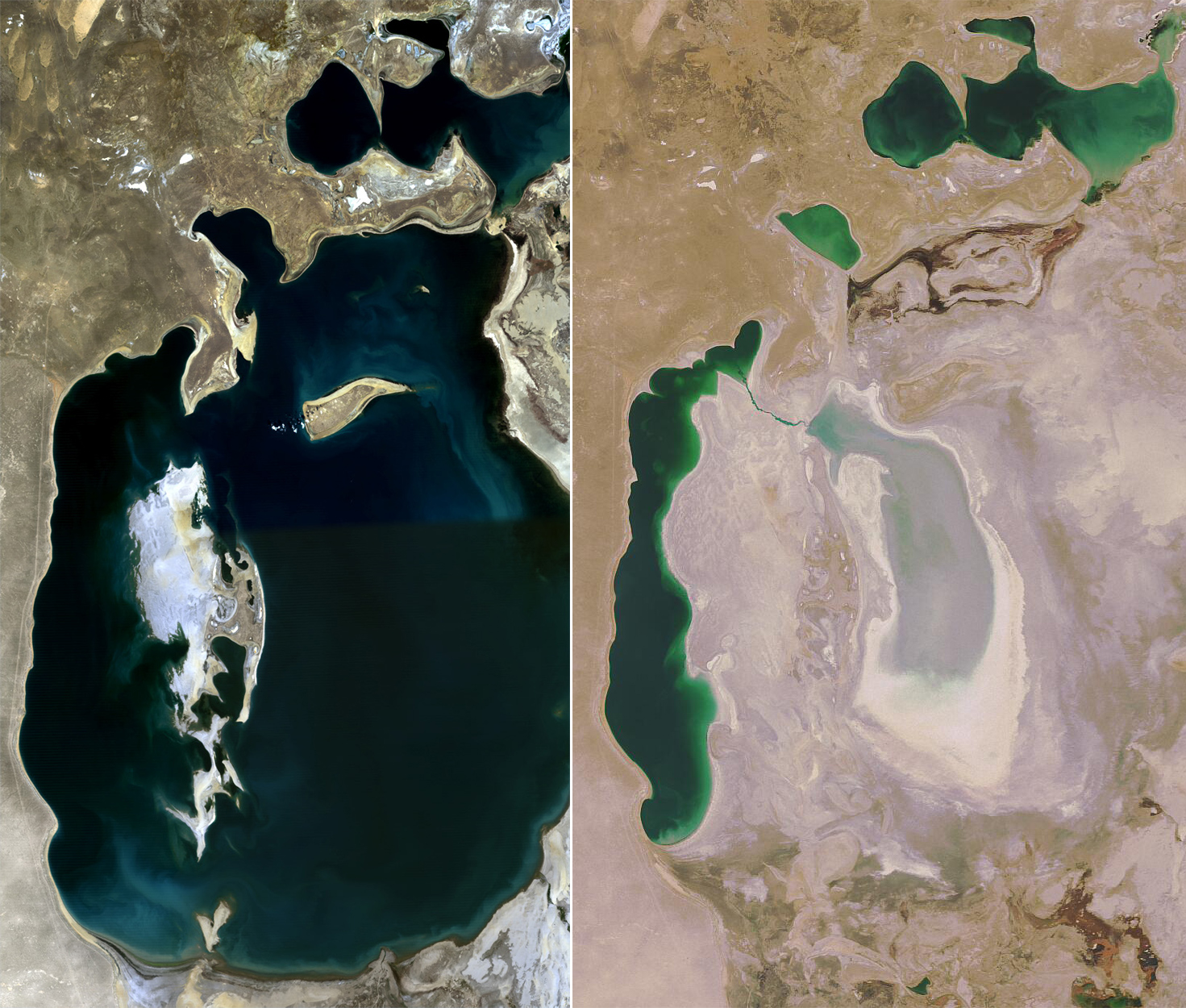
The catastrophic transformation of the Aral Sea was engineered by deliberate, centralized agricultural planning. In the late 1950s and early 1960s, Soviet economic planners initiated a colossal modernization program designed to convert the arid deserts of Uzbekistan, Turkmenistan, and southern Kazakhstan into the premier industrial cotton belt of the socialist bloc. Proclaiming raw cotton as ‘white gold,’ planners decreed that the waters of the Amu Darya and Syr Darya should no longer be ‘wasted’ by discharging into a terminal sea, but instead diverted to irrigate millions of hectares of thirsty desert soils.
Between 1960 and 1980, thousands of kilometers of unlined irrigation canals were gouged through the desert sands. Chief among these was the colossal Karakum Canal—a navigable artificial waterway stretching over thirteen hundred kilometers across Turkmenistan, which siphoned off more than twelve cubic kilometers of water annually from the upper Amu Darya to irrigate fields around Ashgabat. Because the vast majority of these canals were unpaved ditches cut directly through permeable desert gravels and sand, up to fifty percent of the diverted water was lost to seepage and evaporation before ever reaching a cotton furrow.
By the mid-1970s, the combined river discharge reaching the Aral Sea plummeted from an annual average of fifty-five cubic kilometers to virtually zero. Starved of freshwater replenishment in an hyper-arid climate where annual evaporation exceeded one thousand millimeters, the sea began to shrink with alarming velocity. Year after year, the shoreline retreated by dozens of meters. As the water level dropped by more than twenty meters, the vast, shallow eastern basin dried out into blinding white salt flats. By 1987, the retreating waters fractured the unified body into two distinct reservoirs: the Small Aral Sea in the north and the Large Aral Sea in the south. Recognizing the unfolding ecological disaster, Soviet engineers in the late 1970s proposed the colossal Northern River Reversal project—an audacious plan to construct thousands of kilometers of massive canals to redirect Siberian rivers like the Ob and Irtysh southward into Central Asia. However, the multi-billion-ruble megaproject was deemed ecologically perilous and economically unfeasible, formally canceled by Mikhail Gorbachev in 1986. Commercial shipping ground to a halt, canneries shuttered, and fishing trawlers were left stranded in desert sand miles from the retreating waves, creating the surreal ‘ship graveyards’ that symbolize modern environmental disaster.
The Aralkum Desert, Toxic Dust Storms, and Human Health
The drying of the southern Aral Sea basin birthed an entirely new geographic feature on the map of the planet: the Aralkum Desert. Covering over sixty thousand square kilometers of former seabed—an area larger than the Netherlands and Belgium combined—the Aralkum is recognized by earth scientists as the newest and fastest-growing anthropogenic desert on Earth. Unlike natural sand deserts, the floor of the Aralkum is blanketed by a toxic crust of evaporite minerals, dominated by sodium chloride, gypsum, sodium sulfate, and magnesium compounds. Intermixed with these crystalline salts are decades of agricultural chemical runoff: organochlorine pesticides, DDT, lindane, and toxic defoliants like butyl captax, which were applied heavily to surrounding cotton plantations and washed down-river into the terminal lake sediments.
Every spring and summer, intense thermal convection and ferocious desert gales whip across the exposed seabed, generating apocalyptic salt-and-dust storms known locally as the ‘white buran.’ These colossal atmospheric dust plumes, carrying between seventy-five and one hundred and fifty million metric tons of toxic salt and chemical dust each year, rise miles into the troposphere and travel thousands of kilometers. Traces of Aral Sea pesticide salts have been detected in the blood of Antarctic penguins, in the snows of the Himalayas, and on agricultural fields in central Russia, demonstrating the global reach of the disaster.
For the human populations of Karakalpakstan and southwestern Kazakhstan, the desiccation of the sea triggered a catastrophic public health crisis. The local climate, robbed of the moderating thermal inertia of the vast water body, swung into extreme continental severity: summers became two to three degrees hotter and drier, while winters grew significantly colder and more brutal. In communities surrounding the former seabed, local drinking water aquifers became intensely saline and contaminated with heavy metals. The incidence of esophageal and throat cancer, chronic kidney failure, tuberculosis, and respiratory illnesses skyrocketed to levels among the highest in the former Soviet Union. Infant mortality rates doubled, and maternal anemia rates reached over eighty percent, leaving an indelible scar on generations of Karakalpak and Kazakh families. In response to the toxic dust storms, international forestry programs launched massive planting campaigns across the Aralkum, seeding millions of hardy black saxaul (Haloxylon aphyllum) shrubs. The deep, moisture-seeking root systems of the saxaul anchor the shifting salt dunes, creating green vegetative windbreaks that slowly stabilize the toxic desert sands and reduce the severity of airborne salt plumes.
Vozrozhdeniya Island and the Cold War Bioweapons Legacy
Hidden within the remote, sun-baked expanse of the central Aral Sea lay one of the most secretive military installations of the Cold War: the Soviet biological weapons testing complex on Vozrozhdeniya Island (Rebirth Island). Established in 1954 under the administration of the Ministry of Defense, the top-secret facility—designated Aralsk-7—was chosen precisely for its extreme geographical isolation, surrounded by dozens of miles of open, deep water and guarded by strict military checkpoints. For nearly four decades, Soviet scientists at Aralsk-7 conducted open-air field tests on weaponized pathogens, dispersing aerosolized formulations of Bacillus anthracis (anthrax), Yersinia pestis (plague), Francisella tularensis (tularemia), and genetically engineered strains of smallpox over caged monkeys, sheep, and horses on the southern end of the island.
In the northern sector of the island, a self-contained military city named Kantubek housed over fifteen hundred researchers, military officers, and their families, complete with schools, laboratories, residential barracks, and an airstrip with four intersecting runways capable of landing military transport aircraft. In the spring of 1988, following international bioweapons treaties, Soviet military personnel secretly transported hundreds of tons of weaponized anthrax spores stored in stainless steel drums from a production facility in Sverdlovsk (modern Yekaterinburg) to Vozrozhdeniya Island, burying the lethal slurry in giant trenches treated with bleach before hastily abandoning the island in 1992 following the dissolution of the Soviet Union.
As the waters of the Aral Sea continued their relentless retreat throughout the 1990s, an alarming ecological and security crisis emerged: Vozrozhdeniya Island was expanding rapidly toward the mainland. In mid-2001, the shrinking sea bridge vanished completely, and the former island physically merged with the southern mainland of Uzbekistan, creating a continuous land bridge. Biological security experts warned that desert animals—such as rodents, foxes, and antelopes—could freely access the contaminated burial pits, potentially spreading weaponized pathogens to mainland populations. In response, a joint humanitarian operation between the United States Defense Threat Reduction Agency (DTRA) and the government of Uzbekistan deployed specialized environmental remediation teams in 2002, successfully excavating, decontaminating, and neutralizing several hundred metric tons of buried anthrax spores beneath the desert sands.
Dike Kokaral and the Renaissance of the North Aral Sea
Amidst the profound tragedy of the Aral Sea crisis, the twenty-first century has witnessed one of the world’s most dramatic ecological comebacks in the northern basin. Following the collapse of the Soviet Union, the independent Republic of Kazakhstan recognized that saving the entire Aral Sea was hydrologically impossible without halting cotton production across neighboring nations. Instead, Kazakh leaders focused their efforts on saving the northern basin—the Small Aral Sea—which received the discharge of the Syr Darya. After early earthen dikes built by local communities were repeatedly washed away by autumn storms, the government of Kazakhstan partnered with the World Bank in 2001 to fund the ambitious Syr Darya Control and Northern Aral Sea Project (NASP).
The centerpiece of this engineering initiative was Dike Kokaral—a thirteen-kilometer-long concrete and earthen barrage constructed across the narrow Berg Strait separating the North Aral from the desiccated southern basin. Completed in August 2005 at a cost of eighty-six million dollars, the dam features an automated spillway system designed to retain freshwater inflow while allowing excess seasonal floods to discharge into the southern desert. The hydrological response was immediate and astonishing: within less than eight months, water levels behind the dam rose by four meters, reaching an altitude of forty-two meters above sea level—a milestone planners had anticipated would take over four years to achieve.
The environmental renaissance of the North Aral Sea has transformed the regional economy and ecology. As freshwater poured into the basin from the rehabilitated Syr Darya, salinity dropped precipitously from over thirty grams per liter to under eight grams per liter, approaching pure freshwater conditions. Native fish species that had completely vanished from the sea—most notably pikeperch (zander), carp, bream, and roach—returned in abundance, recolonizing the waters from river refuges. Today, commercial fishing has revived across dozens of coastal villages. In Aralsk, where the sea had retreated over one hundred kilometers into the distance, the shoreline has advanced back to within seventeen kilometers of the old harbor docks.
Encouraged by the remarkable success of the project, the government of Kazakhstan and international development partners are advancing plans for Phase 2 of the Northern Aral Sea Project. By heightening the Kokaral dam crest by an additional four meters and constructing a dedicated feeder canal from the Syr Darya directly into the Saryshyganak Gulf, engineers aim to raise the lake level to forty-six meters above sea level, bringing open water directly back into the old port basin of Aralsk. Freshly caught zander is once again packaged in modern processing plants and exported to markets in the European Union, offering an inspiring planetary proof that targeted ecological engineering, sound hydrological management, and visionary international cooperation can breathe resilient life back into our most wounded waters. Biologists monitoring the recovered ecosystem document the return of breeding colonies of Dalmatian pelicans and greater flamingos across the northern reedy shorelines.
Frequently Asked Questions
Where is the Aral Sea located and what are its geographic boundaries?
The Aral Sea is an endorheic terminal lake basin situated in the heart of Central Asia, surrounded by the Kyzylkum and Karakum deserts. It is divided between the Kyzylorda and Aktobe regions of southwestern Kazakhstan to the north and the autonomous Republic of Karakalpakstan in northwestern Uzbekistan to the south. Historically fed by the Amu Darya and Syr Darya rivers, it has no natural outflow to the world ocean.
Why did the Aral Sea shrink so dramatically?
Beginning in the 1960s, the Soviet government undertook massive water diversion engineering projects to irrigate millions of acres of desert for industrial cotton and rice production. Massive canals, most notably the thirteen-hundred-kilometer Karakum Canal, diverted virtually the entire discharge of the Amu Darya and Syr Darya rivers away from the Aral Sea. Starved of freshwater inflow under arid desert evaporation, the sea’s surface area contracted by more than ninety percent over four decades.
What is the difference between the North Aral Sea and the South Aral Sea today?
Today, the Aral Sea is split into completely distinct hydrological systems. The North Aral Sea (Small Aral), situated in Kazakhstan, was stabilized and restored by the construction of the thirteen-kilometer concrete Dike Kokaral dam in 2005. It is fed by the Syr Darya and supports thriving freshwater fish populations. In contrast, the South Aral Sea (Large Aral) in Uzbekistan has largely desiccated into the hypersaline Western Basin and the dry, salt-crusted expanse of the Aralkum Desert.
What are toxic salt dust storms and how do they affect the region?
As the seabed dried, billions of tons of sodium chloride, sulfates, and agricultural chemical residues (including pesticides like DDT and industrial defoliants) were exposed on the desert floor. Fierce desert winds regularly whip up blinding toxic salt storms, blowing millions of tons of chemical-laden dust across Central Asia. These storms have caused severe respiratory illnesses, throat cancer, and kidney diseases in local Karakalpak and Kazakh communities, with dust particles detected as far away as the glaciers of Greenland and Norway.





Share what you know
Been there, grew up there, or know something we missed? Add a comment; corrections with a source are especially welcome.