
The Drowned Corridor: Geography, Dimensions, and Bathymetry
The English Channel—known in French as La Manche, or ‘The Sleeve’—is an epicontinental shelf sea separating the southern coast of Great Britain from the northern coastline of France. Extending approximately five hundred and sixty kilometers from its wide western opening into the Celtic Sea and the Atlantic Ocean to its narrow eastern terminus at the Dover Strait, the Channel encompasses a marine surface area of roughly seventy-five thousand square kilometers.
As a flooded continental shelf, the Channel is remarkably shallow throughout its expanse. Its average depth is merely sixty-three meters, gradually shoaling from one hundred and twenty meters at the Atlantic approaches to an average of twenty to forty meters in the shallow Dover Strait. Along its southern margin, the Brittany and Normandy coastlines are deeply embayed by the Gulf of Saint-Malo, home to the Channel Islands of Jersey, Guernsey, Alderney, and Sark, while the English coast features dramatic headlands, shingle spits, and protected natural harbors including Plymouth Sound and Portsmouth Harbour.
The seabed morphology reveals an ancient, submerged landscape. High-resolution multibeam sonar surveys conducted by marine geologists have mapped a vast paleoriver network carved into the seafloor bedrock, known as the Channel River system (Fleuve Manche). During glacial lowstands, when global sea levels were dropped by more than one hundred meters, the Channel was a dry, periglacial river plain through which the ancestral Rhine, Thames, Meuse, Seine, and Somme united into a single colossal river before emptying into the Atlantic Ocean.
The geological bedrock beneath the English Channel preserves an extraordinary stratigraphy that mirrors the shared geological history of Britain and France. In the central and western Channel, the seafloor is underlain by extensive Jurassic clays, limestones, and sandstones, while the eastern Channel and Dover Strait are carved into thick Cretaceous chalk formations that once formed an uninterrupted plateau. Deep within the central Channel floor lies the Hurd Deep (Fosse Centrale), an enigmatic submarine trench plunging over one hundred and seventy meters into the bedrock, which functioned as a major glacial meltwater spillway and periglacial reservoir.
The geomorphology of the western English Channel is defined by the submerged paleo-valley of the Fleuve Manche, which can be traced across multibeam sonar surveys for hundreds of kilometers toward the edge of the continental shelf. At the shelf break in the Celtic Sea, the ancient channel terminates in a dramatic network of submarine canyons, including the Whittard and Petite Sole canyons, where glacial meltwaters and sediment plumes once cascaded thousands of meters down into the abyssal depths of the Atlantic Ocean. These submarine canyon heads remain hot spots of contemporary upwelling, drawing nutrient-rich waters into the western Channel.

Cataclysmic Origins: The Prehistoric Megafloods That Built an Island
The geological genesis of the English Channel represents one of the most violent and dramatic transformations of landscape in the Earth’s Quaternary history. Prior to the mid-Pleistocene, Britain was firmly anchored to continental Europe by a wide, continuous chalk ridge known as the Weald-Artois Anticline, extending from the present White Cliffs of Dover across to Cap Blanc-Nez. This chalk rampart acted as a natural dam, separating a shallow marine basin in the southwest from a landlocked, ice-dammed proglacial lake in the North Sea.
Roughly four hundred and fifty thousand years ago, during the Anglian (Elsterian) glaciation, the coalescence of the Fennoscandian and British ice sheets trapped meltwater from the ancestral Rhine and Thames, forming a monumental freshwater lake. As water levels rose, the lake catastrophically overtopped the chalk barrier. A cascading megaflood ripped through the soft Cretaceous limestone, gouging out immense plunge pools—the Fosse Dangeard—measuring several kilometers long and up to one hundred meters deep into the bedrock.
A second, even more violent glacial outburst flood occurred approximately one hundred and sixty thousand years ago during the Saalian glaciation. This subsequent megaflood obliterated the remaining structural remnants of the chalk ridge, carving an expansive, braided bedrock valley known as the Dover Strait spillway. When global temperatures rose and glaciers melted at the onset of the current Holocene epoch, rising ocean waters filled this prehistoric breach, permanently severing Britain’s terrestrial bridge to Europe and transforming it into an island nation.
Hydrodynamic modeling of the Pleistocene megafloods reveals that the catastrophic breach of the Dover chalk ridge released peak water discharges estimated at up to one million cubic meters per second—exceeding the flow of the Amazon River by a factor of five. These cataclysmic torrents stripped topsoils across hundreds of square kilometers, carving streamlined bedrock islands, longitudinal scours, and giant gravel bars that remain visible in acoustic sonar imagery today, providing conclusive empirical proof of prehistoric flood events that permanently reshaped European geography.
Tidal Dynamics: Resonant Basins and Extreme Currents
The physical oceanography of the English Channel is governed by powerful, semidiurnal ocean tides entering from the Atlantic Ocean. Because the Channel narrows progressively from west to east while shoaling toward the Dover Strait, it functions as a classic hydrodynamic funnel. The natural resonant frequency of the Channel basin aligns closely with the twelve-hour and twenty-five-minute oceanic tidal period, producing extraordinary tidal amplification along its southern margins.
While the English coastline around the Isle of Wight and Portland experiences moderate tidal ranges of two to four meters, the French coast along the Gulf of Saint-Malo and Normandy witnesses some of the most extreme tidal ranges on the planet. In the Bay of Mont Saint-Michel, the vertical tidal range routinely exceeds fourteen meters (forty-six feet) during spring equinox tides. The sea rushes across the flat intertidal sands at speeds comparable to a galloping horse, transforming Mont Saint-Michel from a terrestrial mount into an isolated island twice daily.
These immense tidal shifts generate violent, localized currents through constricted channels. In the Alderney Race (Raz Blanchard), located between the Channel Island of Alderney and Cap de la Hague on the Cotentin Peninsula, tidal currents accelerate to over ten to twelve knots (six meters per second), creating one of the most turbulent and energetically dense marine environments in Europe. These currents thoroughly mix the shallow water column, preventing thermal stratification and keeping coastal waters saturated with oxygen and suspended nutrients year-round.
The complex tidal architecture of the English Channel produces an unusual hydrodynamic feature known as an amphidromic system, where tidal waves rotate around points of zero tidal amplitude. In the central Channel between Portland Bill and the Cherbourg Peninsula, the interaction of incoming Atlantic tidal waves with reflected waves from the North Sea creates a degenerate amphidromic node. This anomalous interaction produces unusual ‘double high waters’ and extended slack-water periods in Solent harbors such as Southampton, allowing heavy commercial container ships and cruise liners extended navigational windows to dock without battling fierce cross-currents.
The sediment transport dynamics of the English Channel demonstrate a continuous, high-energy redistribution of marine sands and gravels. Driven by the asymmetrical tidal velocities of the flood and ebb tides, vast underwater sandbanks—such as the Goodwin Sands off Deal and the Varne and Ridge banks in the Dover Strait—shift their positions and crest profiles over seasonal and decadal timescales. The Goodwin Sands, a notorious ten-mile-long sandbank exposed at low tide, has claimed more than two thousand documented shipwrecks over recorded history, earning it the grim historical title of the ‘Ship Swallower.’
Subsea Habitats: Chalk Reefs, Kelp Forests, and Coastal Fisheries
Despite intensive maritime transit and centuries of commercial exploitation, the English Channel sustains a remarkably diverse and resilient temperate marine ecosystem. The complex interaction of hard chalk substrates, mobile flint gravels, sandbanks, and oceanic currents creates a diverse mosaic of subsea habitats. Along the Sussex and Kent coasts, submerged chalk reefs support unique borers, including piddock clams that excavate living chambers into the soft rock, alongside dense carpets of sea anemones, bryozoans, and encrusting sponges.
In the western Channel, where clearer Atlantic waters penetrate, extensive forests of kelp (Laminaria hyperborea) flourish on rocky reefs, providing nursery habitat for commercially vital species including European bass, pollack, Atlantic cod, and black sea bream. The Channel’s sandy and gravelly seabeds host major populations of flatfish, including Dover sole, plaice, and turbot, as well as highly lucrative shellfish fisheries centered on brown crab, European lobster, king scallops, and edible cockles.
Cetaceans are frequent visitors to the Channel’s pelagic waters. Resident pods of common bottlenose dolphins inhabit the waters around the Channel Islands and Cornwall, while common dolphins, harbor porpoises, and minke whales follow migratory shoals of herring and sprat through the central seaway. Along the coastal margins, grey seals and harbor seals haul out on remote sandbanks and granite ledges, while the towering chalk cliffs of Dover and Cap Gris-Nez provide nesting ledges for thousands of black-legged kittiwakes, common guillemots, and northern fulmars.
The offshore sandbanks and gravel ridges of the English Channel support specialized temperate benthic communities adapted to high-energy hydrodynamic disturbance. In areas of strong current flow, coarse flint gravels and shell-hash beds are colonized by the native European flat oyster (Ostrea edulis) and dense aggregations of the ross worm (Sabellaria spinulosa). These biogenic tube-building worms construct extensive biogenic reefs that stabilize mobile sand sheets, elevate biodiversity, and provide complex three-dimensional micro-habitats for hundreds of species of small crustaceans, polychaetes, and juvenile demersal fish.
The English Channel’s rich biological productivity is further enhanced by thermal fronts that form each spring in the western approaches. As surface waters warm under lengthening sunlight, a distinct seasonal thermocline develops in deeper Atlantic waters, whereas shallow coastal waters remain thoroughly mixed by intense tidal currents. Where these two water masses meet—at the Ushant and Western Channel fronts—intense nutrient mixing stimulates massive blooms of phytoflagellates, attracting feeding concentrations of basking sharks, leatherback sea turtles, and pilot whales along the continental margin.
The Moat of Nations: Invasions, Empires, and Naval Defenses
Throughout recorded human history, the English Channel has served simultaneously as a defensive moat shielding the British Isles from continental invasion and a vital commercial conduit linking European cultures. In fifty-five and fifty-four BCE, Julius Caesar launched his pioneering military expeditions to Britain across the Channel, followed nearly a century later in forty-three CE by the full-scale Roman conquest ordered by Emperor Claudius, who transformed the Channel into an imperial highway linking Britannia with Rome.
In ten sixty-six, the Channel bore witness to the Norman Conquest, when William the Conqueror assembled a fleet of hundreds of transport vessels to land an army at Pevensey, fundamentally reshaping the linguistic, cultural, and political destiny of the English-speaking world. Five centuries later, in fifteen eighty-eight, the Spanish Armada of King Philip II attempted to navigate the Channel to support an invasion force from the Spanish Netherlands, only to be scattered by English fireships off Gravelines and battered by fierce Channel gales.
The waterway reached its military zenith during the twentieth century. In May and June of nineteen forty, the Dunkirk evacuation (Operation Dynamo) mobilized a flotilla of over eight hundred civilian and military vessels—the legendary ‘Little Ships of Dunkirk’—to rescue more than three hundred and thirty-eight thousand Allied soldiers trapped on French beaches. Four years later, on June sixth, nineteen forty-four (D-Day), the Channel hosted Operation Neptune, the largest amphibious invasion in human history, transporting over one hundred and fifty-six thousand Allied troops across the stormy waters to storm the beaches of Normandy and liberate Western Europe.
The archaeological record beneath the waters of the English Channel encompasses both classical and modern shipwrecks, alongside submerged prehistoric landscapes dating to the Mesolithic era. During early post-glacial periods when sea levels were still rising, prehistoric human populations inhabited coastal riverbanks and estuaries that now lie submerged beneath thirty meters of water off the Isle of Wight and the Cotentin Peninsula. Marine archaeologists have recovered worked flint tools, hearth remnants, and preserved timber structures from these submerged terrestrial sites, offering unprecedented glimpses into the lives of ancient hunters who inhabited the fertile valley of the Fleuve Manche before it was flooded by the sea.
The Global Arterial: Traffic Separation Schemes and the Channel Tunnel
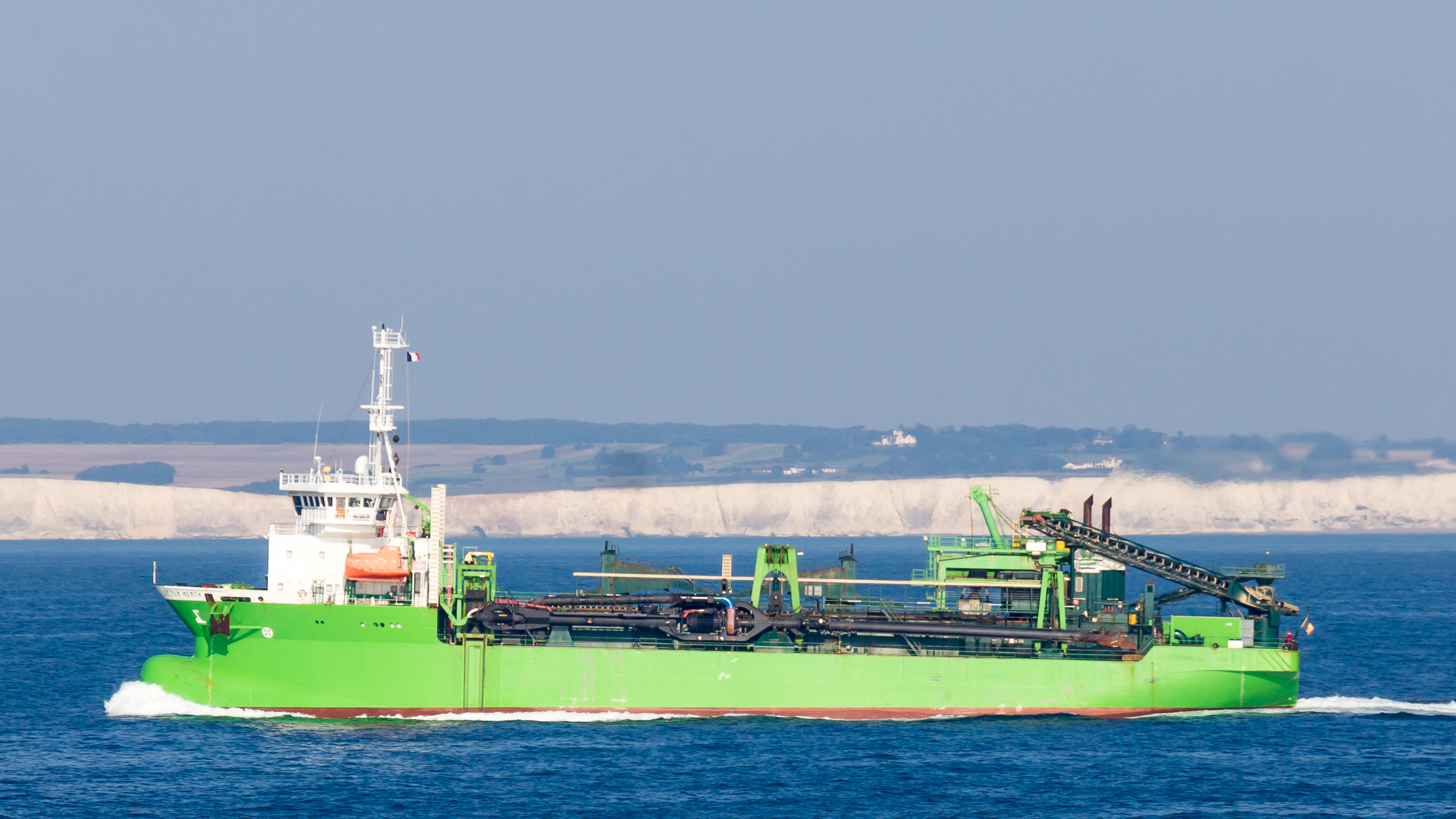
In the modern era, the English Channel remains an undisputed marvel of international maritime logistics and civil engineering. The Dover Strait is universally recognized as the busiest shipping lane on Earth, accommodating more than five hundred commercial cargo ships, chemical tankers, and container giants daily, representing roughly twenty percent of global seaborne trade. To prevent catastrophic maritime collisions, the International Maritime Organization established the pioneering Dover Strait Traffic Separation Scheme, featuring radar-monitored inbound and outbound shipping lanes coordinated by the Channel Navigation Information Service (CNIS) in Dover and CROSS Gris-Nez in France.
Superimposed across this dense longitudinal traffic is a perpendicular network of high-capacity cross-channel ferries and hovercraft operations linking ports such as Dover, Portsmouth, and Newhaven with Calais, Dunkirk, Le Havre, and Cherbourg. Navigating large car ferries through moving lanes of two-hundred-thousand-ton merchant vessels across four-knot tidal currents remains one of the supreme tests of commercial pilotage.
Connecting the two continents beneath the seabed is the monumental Channel Tunnel, opened in nineteen ninety-four after six years of intensive subsea excavation. Stretching fifty point five kilometers between Folkestone and Coquelles—with an undersea section of thirty-seven point nine kilometers bored through impermeable Cretaceous chalk marl—the tunnel accommodates high-speed Eurostar passenger trains and massive freight shuttles. By linking London and Paris in just over two hours, this modern wonder of engineering has effectively reconnected the ancient land bridge severed by Pleistocene megafloods, providing a direct terrestrial link between Britain and continental Europe.
Today, environmental management in the English Channel requires intense bilateral cooperation between British and French maritime authorities. Protecting the sensitive chalk reefs, regulating depleted commercial fisheries under sustainable quotas, and managing the risks posed by hundreds of millions of tons of hazardous petrochemicals transiting through the Dover Strait require constant joint oversight. Coordinated pollution response vessels, real-time satellite environmental monitoring, and designated marine conservation zones work together to ensure that this ancient marine gateway remains resilient amidst the pressures of twenty-first-century commerce.
Frequently Asked Questions
How was the English Channel geologically created?
Until roughly 450,000 years ago, Britain was physically connected to mainland Europe by a massive ridge of chalk hills known as the Weald-Artois Anticline. During the Elsterian and Saalian glaciations, a gigantic freshwater proglacial lake accumulated in what is now the southern North Sea, dammed by Scandinavian ice sheets. As the lake overtopped the chalk dam, it triggered a series of catastrophic megafloods that blasted through the ridge, excavating colossal plunge pools and carving an immense valley system (the Fosse Dangeard) that permanently separated Britain from the continent once post-glacial sea levels rose.
What is the narrowest point of the English Channel?
The narrowest constriction is the Dover Strait (Strait of Dover or Pas de Calais), measuring approximately thirty-three kilometers (twenty-one miles) between the South Foreland near Dover in Kent and Cap Gris-Nez near Boulogne-sur-Mer in Pas-de-Calais. On clear days, the opposing shorelines and landmarks are easily visible across the strait with the naked eye.
How deep is the Channel Tunnel beneath the seabed?
The Channel Tunnel runs at an average depth of forty meters (one hundred and thirty feet) below the sea floor, descending to a maximum depth of seventy-five meters (two hundred and forty-six feet) beneath sea level. Engineers selected a specific geological formation—the Chalk Marl layer—which provided an impermeable, relatively stable medium for massive tunnel boring machines.
Why is the maritime traffic in the English Channel so hazardous?
Navigating the English Channel involves a combination of intense vessel volume, cross-channel passenger ferry traffic, restricted navigable depths, complex tidal streams exceeding five knots, and sudden maritime weather hazards including dense sea fog (haar or crachin) and Atlantic gales. To prevent catastrophic collisions, the International Maritime Organization established the Dover Strait Traffic Separation Scheme in 1967, which routes inbound and outbound vessels into dedicated, radar-monitored marine lanes.





Share what you know
Been there, grew up there, or know something we missed? Add a comment; corrections with a source are especially welcome.