
The Shelf Basin and Drowned Doggerland

The North Sea is a dynamic epicontinental shelf sea covering 570,000 square kilometers on the northwestern continental margin of Europe. Enclosed by Great Britain to the west, the European mainland to the south and east, and Norway to the northeast, it opens into the Norwegian Sea and Atlantic Ocean to the north. To the southwest, it connects to the Atlantic through the narrow Dover Strait and English Channel.
Unlike deep oceanic trenches, the North Sea is shallow across most of its extent. Its average depth is ninety meters. It slopes gently from south to north. In the southern bight, large sandbanks lie submerged beneath less than thirty meters of water. The central basin is dominated by Dogger Bank. This is a submerged moraine plateau rising to within fifteen meters of the sea surface. Only along its northeastern margin does the seabed drop into the Norwegian Trench. This is a deep glacial trough gouged by Ice Age ice streams that plunges to over seven hundred meters off the Norwegian fjords.
The history of this shallow shelf is linked to the disappearance of Doggerland. During the Last Glacial Maximum, global sea levels were lower by one hundred and twenty meters. The North Sea basin did not exist as a marine body. Instead, it was an undulating plain connecting Britain directly to continental Europe. Following the retreat of ice sheets, Doggerland emerged as a fertile landscape. It featured birch woodlands, freshwater lakes, meandering river valleys, and coastal marshlands.
For several thousand years, Mesolithic hunter-gatherer communities lived in this region. They hunted red deer, trapped birds, and fished in broad rivers. Modern fishing trawlers dredging the seabed frequently pull up prehistoric artifacts in their nets. Finds include flint tools, bone harpoon points, and fossilized bones of mammoths, woolly rhinoceroses, and lions. As warming post-glacial seas rose, Doggerland slowly shrank into an isolated island archipelago. Around 6200 BCE, a catastrophic submarine landslide off Norway—the Storegga Slide—triggered a powerful tsunami. The giant wave swept across the basin, drowning the remaining lowlands beneath the sea.
Along the western margin, striking chalk headlands mark the edge of the shelf. At Flamborough Head and the White Cliffs of Dover, vertical chalk bluffs meet the North Sea waves. These cliffs were formed from the compressed shells of microscopic Cretaceous coccolithophores. Constant wave action undercuts the soft chalk, carving sea caves, arches, and isolated stacks that retreat landward by several centimeters each year.
The central shelf floor also preserves deep tunnel valleys carved by pressurized subglacial meltwater during Pleistocene ice advances. Features like the Silver Pit and Devil’s Hole form steep underwater depressions descending over fifty to one hundred meters deeper than the surrounding seabed. Today, these relict glacial channels act as local sediment traps and shelter deep-water prawns and flatfish from strong surface storm currents.
The Wadden Sea and Intertidal Sand Flats
Along the southeastern margin of the North Sea lies the Wadden Sea. This is the largest unbroken system of intertidal sand and mud flats on Earth. It extends for five hundred kilometers along the coasts of the Netherlands, Germany, and Denmark. A barrier chain of fifty-four islands shields this shallow marine realm from open ocean waves. These islands include Texel, Terschelling, Norderney, Sylt, and Fanø.
The Wadden Sea is governed by the twice-daily rhythm of the tides. Tidal currents surge through deep inlets between the barrier islands, flooding the back-barrier lagoons. As the tide turns and ebbs, water drains back into the North Sea. This cycle exposes thousands of square kilometers of glistening intertidal mudflats, sandbanks, and mussel beds. These intertidal flats support immense populations of burrowing lugworms, mud snails, and cockles.
This biological wealth turns the Wadden Sea into an essential feeding station along the East Atlantic Flyway. Each year, ten to twelve million migratory shorebirds stop here to feed on mudflat invertebrates. Key species include red knots, bar-tailed godwits, and oystercatchers. They build fat reserves needed for their flights between Arctic breeding grounds and wintering sites in Africa. The shallow lagoons also serve as nursery areas for North Sea flatfish, including plaice and sole, and support resident populations of harbour seals and grey seals.
Behind the barrier islands lie extensive salt marshes known locally as groden. These vegetated intertidal zones are covered by salt-tolerant plants like glasswort and sea lavender. They trap fine marine sediments, slowly building land upward and acting as natural buffers against wave energy during seasonal storms.
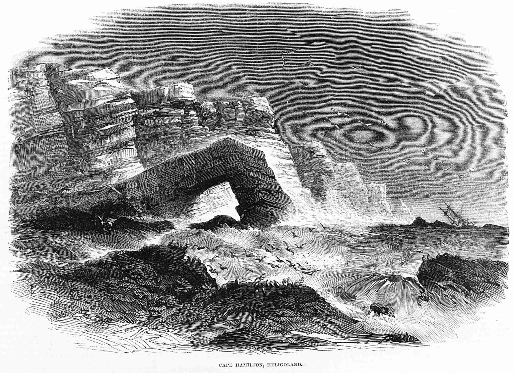
In the German Bight, the red sandstone island of Heligoland stands as an isolated sentinel in the open sea. Battered by fierce North Sea gales, its sheer Buntsandstein cliffs and detached sea stacks—such as the Lange Anna—provide the only hard-rock nesting cliffs in the southeastern basin. Thousands of northern gannets and common guillemots nest along its red stone ledges, adding valuable habitat diversity to the shallow sandy shelf.
The benthic ecosystem of the Wadden Sea has also undergone significant biological shifts over recent decades. Native blue mussel beds (Mytilus edulis) have increasingly intertwined with introduced Pacific oysters (Magallana gigas). These invasive bivalves form dense, rigid oyster reefs that withstand strong wave action better than soft mussel beds. While altering native species composition, these oyster reefs provide structural microhabitats for crabs, barnacles, and small fish, modifying the intertidal mudflat ecology.
Amphidromic Tides and Storm Surge Risks
The physical oceanography of the North Sea is driven by a strong tidal system. Atlantic tidal waves enter the basin from the north between Scotland and Norway, with a second pulse entering through the English Channel. As these waves travel across the shallow shelf, the Coriolis effect deflects them to the right. They circulate counter-clockwise around three distinct amphidromic points. These points are oceanographic nodes where tidal range drops to virtually zero.
This amphidromic geometry creates major variations in tidal range. Along the southern coast of Norway, near an amphidromic node, the tidal range is small, rarely exceeding thirty centimeters. In contrast, as the tidal wave travels south along the eastern coast of England and enters the German Bight, its amplitude increases sharply. In the estuaries of the Humber, Thames, and Elbe, tides routinely exceed six to seven meters. These strong currents scour navigation channels, move sandbanks, and stir coastal waters.
The shallow depth and funnel-like shape make the southern North Sea vulnerable to severe storm surges. In autumn and winter, deep low-pressure systems can stall over the basin. They generate persistent northerly and northwesterly gales. These winds push huge volumes of water southward into the narrowing southern bight. When this wind-driven surge coincides with spring high tide, water levels can rise three to four meters above normal.
The most famous modern storm flood struck during the night of January 31, 1953. The Great North Sea Flood overtopped dykes across the Netherlands and eastern England. The disaster claimed over two thousand lives and flooded vast areas of low-lying farmland. The tragedy led to the construction of modern coastal defense barriers. The Dutch Delta Works—including the storm-surge barrier on the Eastern Scheldt—and the Thames Barrier in London now protect millions of people from severe marine flooding.
Modern storm warning networks use radar satellites, offshore buoys, and computer models to track approaching surge waves. Storms in 1978 and 2013 generated surge heights comparable to 1953, but improved movable barriers and reinforced sea dykes prevented catastrophic inundation, showing how coastal engineering protects vulnerable lowland coastlines.
Among the most remarkable engineering responses is the Maeslantkering at the entrance to Rotterdam harbor. Completed in 1997, this barrier consists of two colossal curved steel gates, each as large as the Eiffel Tower laid on its side. Operating on floating ballasts, the gates swing shut across the 360-meter-wide Nieuwe Waterweg channel only when computer systems detect an impending storm surge exceeding three meters, shielding the densely populated Rhine estuary from extreme North Sea storm surges.
The Norwegian Trench and Deep Circulation
Along the northeastern side of the basin lies its deepest oceanographic feature: the Norwegian Trench, or Norskerenna. Extending for nine hundred kilometers around southern and southwestern Norway, this submarine canyon averages two hundred to three hundred meters in depth. It reaches 725 meters in the Skagerrak deep. Carved by the Norwegian Channel Ice Stream during glacial epochs, the trench functions as a deep marine channel connecting the North Sea to the Norwegian Sea.
Circulation in the trench is governed by the Norwegian Coastal Current. This current carries low-salinity surface water northward along the Norwegian coast. The fresh water originates from Baltic Sea outflow and continental river discharge, moving over one million cubic meters of water per second into the North Atlantic. Beneath this lighter surface stream, an undercurrent of cold, salty Atlantic water flows southward into the trench, supplying oxygen to deep waters in the Skagerrak and Kattegat.
The submarine walls of the Norwegian Trench are lined with cold-water coral reefs built by Lophelia pertusa. Living in dark waters at temperatures between 6°C and 9°C, these deep-sea coral formations grow several meters high. They provide essential structural shelter for deep-water fish like redfish, ling, and tusk, as well as squat lobsters and glass sponges.
To the west, Atlantic water enters the North Sea through the Fair Isle Channel and the Pentland Firth between Scotland and the Orkney Islands. These narrow straits experience rapid tidal races that mix the water column from surface to seabed. In summer, the central North Sea develops distinct thermal layering. A warm surface layer sits above a cold bottom water mass. This isolated bottom pool stays below 8°C all summer, serving as a critical habitat for cold-water fish like cod and haddock.
The sandy shallows of Dogger Bank also sustain immense populations of lesser sandeels (Ammodytes marinus). These small, slender fish burrow into clean sand during winter and emerge in spring to feed on copepods. Sandeels represent the keystone forage species of the North Sea, serving as the primary food source for seabird colonies on the cliffs of eastern Britain, including Atlantic puffins, black-legged kittiwakes, and common murres, as well as marine mammals like harbour porpoises.
Historic Fisheries and the Offshore Energy Revolution
For over a thousand years, the biological productivity of the North Sea supported coastal communities across northwestern Europe. Shallow waters, combined with nutrients carried by the Rhine, Elbe, and Thames rivers, fuel strong spring phytoplankton blooms. These blooms support huge schools of pelagic and groundfish, including Atlantic herring, cod, haddock, and mackerel.
In the Middle Ages, the herring fishery became an economic foundation for the region. Dutch fishermen developed the herring buss, a sturdy wooden ship designed for gutting, salting, and barreling fish at sea immediately after hauling drift nets. This innovation allowed fleets to stay on distant fishing grounds for months. It produced substantial commercial wealth that helped finance the Dutch Golden Age. Over time, intensive fishing pressure caused stocks to decline, leading to modern fishing quotas and marine conservation policies under European agreements.
In the twentieth century, the North Sea became a major center for oil and natural gas production. The discovery of the Groningen gas field in 1959 sparked offshore exploration. Major discoveries followed, including the Ekofisk field in Norway and the Forties and Brent fields in Britain. Engineers designed massive steel platform jackets and concrete gravity structures capable of enduring twenty-meter storm waves and freezing winter gales. Undersea pipelines transported crude oil and gas to coastal refineries, transforming regional economies.
Today, the North Sea is leading a major transition toward offshore renewable energy. Shallow water across Dogger Bank and the German Bight, combined with strong, steady winds, provides ideal conditions for offshore wind farms. Giant turbine arrays, such as the Hornsea and Dogger Bank projects, generate gigawatts of clean electricity. Power cables carry this renewable power to electrical grids in Britain, Germany, and the Netherlands.
To integrate this offshore wind generation, European nations are developing high-voltage direct current (HVDC) subsea interconnectors across the basin floor. Systems like the North Sea Link between Norway and Britain allow countries to trade wind power and hydro storage across national borders in real time. Future plans envision artificial energy islands constructed in the central North Sea to serve as regional offshore power hubs, combining wind generation with green hydrogen production and turning this stormy shelf sea into an integrated green energy backbone for Europe.
As older petroleum platforms reach the end of their operational lives, decommissioning programs are reshaping marine habitats. Submerged steel platform legs often develop into artificial reefs covered in blue mussels, barnacles, and soft corals. These structures attract cod, pollock, and seals, creating unexpected biodiversity hotspots in heavily fished waters and illustrating the evolving relationship between industry and marine ecology in the modern North Sea.
Frequently Asked Questions
What was Doggerland and how was it lost beneath the North Sea?
Doggerland was a fertile, inhabited landmass that occupied the southern and central basin of the modern North Sea during the early Holocene epoch. Following the retreat of the last ice age glaciers, Doggerland connected the British Isles directly to modern-day Denmark, Germany, and the Netherlands. It featured rolling hills, dense river networks, and marshlands inhabited by Mesolithic hunter-gatherer populations. As post-glacial sea levels rose between 9000 and 6000 BCE, Doggerland gradually shrank to an isolated low-lying island. Its final submergence occurred around 6200 BCE, when a colossal submarine landslide off Norway (the Storegga Slide) generated a catastrophic tsunami that swept across the North Sea, drowning the remaining landscape beneath the waves.
How do amphidromic points govern the unusual tides of the North Sea?
Tides in the North Sea are generated primarily by oceanic tidal waves entering from the North Atlantic through the gap between Scotland and Norway, with a secondary pulse entering through the English Channel. Because of the Coriolis effect, these waves rotate counter-clockwise around three distinct amphidromic points (nodes where tidal amplitude is zero). As a result, coastal tidal ranges vary dramatically depending on location: near amphidromic nodes along the southern Norwegian coast, tides are negligible (less than 0.5 meters), whereas along the funneling estuaries of eastern England and the German Bight, tidal ranges exceed six to seven meters.
What caused the catastrophic North Sea Flood of 1953?
The disastrous flood of January 31 – February 1, 1953, resulted from an extraordinary confluence of meteorological and astronomical factors. A deep, slow-moving North Atlantic low-pressure system tracked across Scotland into the North Sea, generating sustained northerly hurricane-force winds that piled massive volumes of water southward into the shallow, narrowing southern bight. This storm surge arrived precisely at astronomical spring high tide, driving water levels more than 3.3 meters above normal. Overtopping dykes in the Netherlands and eastern England, it inundated hundreds of thousands of hectares and claimed over 2,100 lives, fundamentally reshaping modern coastal defense engineering.
Why is the North Sea a focal point for the modern offshore energy transition?
The North Sea possesses an ideal combination of oceanographic and geographical characteristics for offshore wind power. Its vast continental shelf features extensive shallow sandbanks, such as Dogger Bank, where water depths are between fifteen and thirty meters, allowing the installation of fixed-bottom wind turbine foundations. Furthermore, strong and remarkably consistent westerly winds blow across the sea throughout the year without terrestrial friction, providing an uninterrupted kinetic energy source adjacent to Europe’s most heavily populated industrial centers.






Share what you know
Been there, grew up there, or know something we missed? Add a comment; corrections with a source are especially welcome.