
In November 2011, a remotely operated vehicle from the research ship RRS James Cook descended to Longqi on the Southwest Indian Ridge. Its cameras recorded mineral chimneys and animals living around hot fluid emerging from the seabed. Nearly three kilometres of water separated this community from the sunlit surface.[reference needed] The snails and mussels were part of a food web sustained by microbes that obtain energy from chemical reactions.[reference needed] Darkness had not made the place barren.
Above Longqi lies the Indian Ocean, the third-largest ocean basin. Its waters extend from eastern Africa toward Australia and the islands of Southeast Asia, with the Arabian Sea among its northern reaches.[reference needed][reference needed] Seasonal winds move surface water and carry moisture toward land. Coastal towns have used those changing winds to maintain connections across the basin.[reference needed][reference needed] Below the shipping routes and coral shallows, ridges and deep trenches give the ocean a second landscape. Longqi is one inhabited place within it.
A suspected mistake led Joaquim Goés back to the wind
Oceanographer Joaquim Goés thought something had gone wrong with his maps. His team was estimating nitrate in the ocean from satellite observations, but the Arabian Sea appeared to contain unexpectedly high amounts. Rather than discard the result, they began checking the observations behind it. Chlorophyll measurements also showed unusually strong growth of phytoplankton during the period they examined.[reference needed] The apparent mistake became a question about what was happening in the water.
Phytoplankton need light and nutrients. At the surface there is light, but nutrients can be used up as organisms grow. Colder water rising from below can supply more. Goés and his colleagues found cooler surface conditions alongside the increase in chlorophyll, then examined winds that could have driven stronger upwelling.[reference needed] Their investigation followed a chain from a map through living cells and water temperature to the moving air above.
The monsoon gives the Arabian Sea a strong seasonal rhythm. In summer, moist air moves toward the warmer Asian landmass. Winds push surface water away from parts of the western sea, allowing deeper water to rise near Somalia and the Arabian Peninsula. In winter, the broad circulation reverses as the land cools.[reference needed] The wind that brings rain to land can therefore also change the food available in the sea.
Goés’s investigation concerned observations from a particular span of years. It connected stronger winds and upwelling with changes in the phytoplankton, then pursued a possible link with reduced Eurasian snow cover.[reference needed] The larger surprise was geographical: a change over distant land could be connected to organisms in an ocean. Between them lay a sequence of physical processes, each doing its part. The explanation required following those connections rather than treating the sea as a self-contained bowl.
To investigate the distant snow connection, Goés worked with climate specialist John Fasullo. Snow reflects sunlight; its extent can affect how strongly land warms as the seasons change. Land and sea warm at different rates, helping establish the pressure differences behind the monsoon. The researchers were tracing how changes over Eurasia might alter that familiar mechanism.[reference needed] A snow-covered surface and a bloom of marine organisms seem to belong to separate worlds. Air moving between them supplies part of the connection, with water rising beneath the wind at the other end.
Kilwa kept part of the ocean’s traffic on land

At Kilwa Kisiwani, off Tanzania, the remains include the Great Mosque, the Husuni Kubwa palace and domestic buildings. Along with nearby Songo Mnara, the town belonged to a network of Swahili ports trading across the Indian Ocean. Its prosperity was particularly marked during the medieval period.[reference needed] Cargo did not merely pass the island. Trade helped support a city, with places to live, worship and exercise authority.
Coral stone and lime mortar made those buildings part of their coastal setting. Imported objects, including porcelain, connect the archaeological remains to exchanges with Arabia, India and China. Kilwa also produced its own coinage.[reference needed] The port had institutions and decisions of its own. A bowl arriving from abroad could enter a household whose architecture and habits were locally made, rather than turn that household into a copy of the place the bowl came from.
North along the coast, Lamu in Kenya remains a living Swahili town. Coral stone, mangrove timber, courtyards and carved doors form part of its building tradition. Long maritime connections contributed to its development, alongside the work of local builders and residents.[reference needed] The town’s narrow spaces and domestic interiors give those connections an everyday setting. The harbour opens outward; the home has its own arrangements within.
Both towns tie a wide sea to particular materials. Mangrove wood could become part of a roof or a doorway; coral stone could become a wall.[reference needed][reference needed] At Kilwa, the surviving arches still divide an interior into spaces where people gathered. At Lamu, buildings remain part of a town that people inhabit. The sea connected these places to others, but the work of making a town took place ashore.
South Keeling encloses several kinds of water
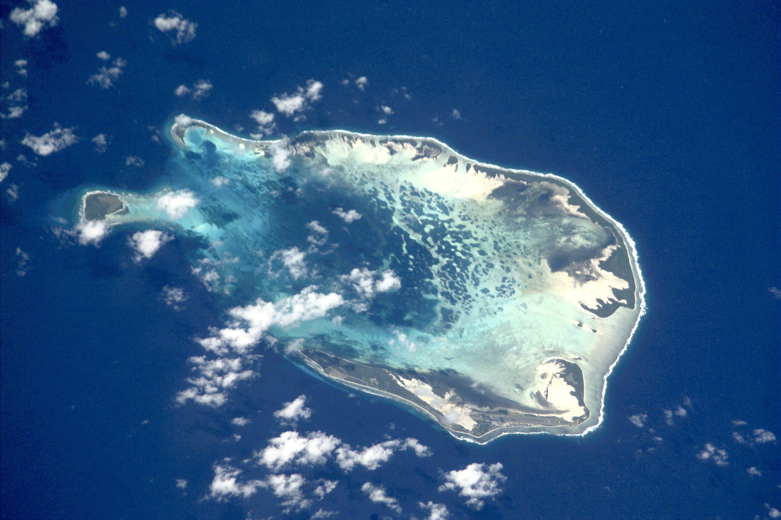
On 19 January 2024, an astronaut photographed South Keeling in the Cocos (Keeling) Islands. The curved rim of islets enclosed water whose colour changed from pale blue-green shallows to a darker northern lagoon.[reference needed] A single atoll contained a variety of depths and surfaces. The enclosing land did not make the water within it uniform.
The Cocos group includes a northern island separate from the southern atoll. Around South Keeling, coral structures, accumulated sediment and lagoon water occupy different positions within the same small archipelago.[reference needed] Land and reef are closely connected, but a reef can remain submerged where an islet rises above the water. The distance between those conditions can be small enough to fit within one overhead view.
Openings between the islets connect the lagoon with the surrounding sea. The southern shallows and deeper northern water form part of one interior, with the island rim curving around them.[reference needed] The contrast gives the atoll a shape beyond the familiar ring. There is an inside with its own variety, as well as an edge facing the ocean.
Reef-building corals make limestone skeletons. Over generations, their growth helps create structures that can support very different arrangements of reef, shore and lagoon. Fringing reefs lie close to land; barrier reefs stand farther offshore; an atoll encloses a lagoon within a ring-like reef system.[reference needed] These forms emerge through a history of growth and change. The little islets above the water depend on a much larger structure below.
Aldabra’s tortoises live on an old reef

At Aldabra in Seychelles, giant tortoises inhabit land formed from coral limestone. The atoll’s raised reef surface surrounds a shallow lagoon, with mangroves, seagrass and marine habitats forming part of the wider protected area.[reference needed] An animal walking over the island is moving across the remains of an earlier reef. Geological history has become ground under its feet.
The limestone shore and the lagoon meet in a complicated margin of channels and vegetation. Mangroves occupy places where roots and water share the same space, while seabirds and marine organisms use other parts of the atoll.[reference needed] The tortoises are its best-known inhabitants, but they live within this larger set of relationships. Protecting an individual species involves protecting the setting that allows it to persist.
The Seychelles Islands Foundation manages that work through research, monitoring and controls on activities. Its marine programme, begun in 2013, follows reef habitat and fish communities; other programmes monitor birds. Biosecurity and the removal or control of introduced species are continuing concerns.[reference needed] Remoteness reduces some pressures without removing them all. Visitors, supplies and research work still need procedures that keep an unwanted organism from arriving with them.
Tourism is also managed as part of conservation. The foundation’s stated approach calls for closely supervised activity that avoids damaging the atoll’s values and helps support protection financially.[reference needed] This is practical work: setting conditions for access, checking for change and deciding how to respond. Aldabra’s isolation is a geographical condition. Its continued protection depends on people maintaining an organised presence there.
A coral loses partners before it loses its life
Coral bleaching begins within a living relationship. Many corals contain symbiotic algae that contribute to their nutrition and colour. Under stress, corals can lose these algae, leaving pale tissue through which the white skeleton becomes visible. A bleached coral can still be alive, but a prolonged loss of its partners can make recovery difficult.[reference needed] The colour change marks a disruption before it necessarily marks death.
Temperature stress is a major cause of bleaching, although other conditions can trigger it too. Recovery depends on how severe and persistent the stress becomes.[reference needed] A reef’s future therefore involves events extending beyond the moment when its colour changes. The animals need conditions that allow their partnerships to recover. Repeated or lasting stress can shorten that opportunity.
Hard corals build the framework used by many other organisms. The limestone structure grows through the accumulation of skeletons, while the living layer continues to interact with water, light and neighbouring species.[reference needed] Damage to that living system is different from a change in the colour of the sea around an island. The lagoon at South Keeling can be pale because it is shallow; bleaching concerns what is happening inside coral tissue.
At Aldabra, repeated monitoring gives researchers a way to follow reef and fish communities over time.[reference needed] A survey can return to a place, compare observations and ask what has changed since the last visit. That patient repetition gives a protected reef a history of measurements alongside its much longer history of growth. The work links a small patch of seabed to changing conditions in the surrounding basin.
Two sides of the ocean can pull apart
Australia’s rainfall can be affected by differences in temperature far out in the Indian Ocean. During a positive Indian Ocean Dipole, the western tropical sea is relatively warm and the eastern side relatively cool compared with their local averages. The Australian Bureau of Meteorology associates that pattern with reduced moisture for parts of Australia. A negative phase tends to favour increased winter and spring rainfall in parts of the south.[reference needed]
The comparison uses departures from usual conditions. A tropical region can be cooler than its own average while still containing warm water. What changes is the contrast with another part of the basin, and the atmospheric circulation associated with it.[reference needed] This gives the ocean an east–west relationship as well as a seasonal one. The two patterns can interact without becoming the same thing.
The dipole differs from an overall warming or cooling of the basin. NOAA describes both kinds of variation, along with their connections to rainfall in eastern Africa and the Maritime Continent.[reference needed] In a positive dipole, wetter conditions tend to occur in the west and drier conditions in the east. The word “tend” leaves room for other influences. No single index decides every season on every shore.
Those relationships bring an island reef, an Australian farming region and an East African coast into the same climatic discussion. Their immediate concerns differ, yet all can be affected by changes in heat and air circulation over the basin.[reference needed][reference needed] The monsoon returns through the year; the dipole describes an additional pattern of departure. A familiar season can arrive under unfamiliar conditions.
The deepest ground lies off Java
Near Indonesia, the Java Trench carries the seafloor down into the deepest surveyed part of the Indian Ocean. A Five Deeps expedition survey reported a maximum of about 7.2 kilometres, using modern equipment to investigate a place beyond ordinary shipboard observation.[reference needed] That vertical distance is far greater than the depth of the lagoon at an atoll. Both lie beneath the same sea surface.
The trench and the ocean’s ridges are different kinds of feature. Along a mid-ocean ridge, tectonic plates move apart and new crust forms. Mountains and valleys extend along these spreading centres beneath the water.[reference needed] A ship can cross a wide, apparently level horizon while travelling over a landscape with major changes in height. The surface hides the relief without making it less substantial.
The Five Deeps team used a multibeam sonar system to map parts of the deep ocean, with measurements from a submersible and landers helping check what they found. Their work placed the Indian Ocean’s deepest surveyed point within the Java Trench.[reference needed] Such surveying changes the detail of what is known about the seabed. A named trench contains ridges, slopes and deeper pockets that require their own measurements.
In places along spreading ridges, seawater enters cracks in the crust, is heated and returns through hydrothermal vents. The returning fluid carries chemicals that react as it meets colder surrounding water.[reference needed] Mineral deposits can build chimneys around the flow. The ground is made and altered through these movements, while organisms occupy the conditions created nearby. At Longqi, a survey brought that meeting of rock, water and life into view.
Dragon’s Breath has neighbours with different needs
Longqi means “Dragon’s Breath”. Before the 2011 remotely operated dives, autonomous equipment had photographed signs of active venting there. The later expedition could collect samples as well as images, allowing researchers to identify animals and compare the community with other vent fields.[reference needed] A camera had established that something was present. Samples made it possible to ask more precise questions about who lived there. The published survey figure records the different chimney forms encountered during those dives.[reference needed]
Jon Copley and colleagues reported 21 larger animal taxa from the survey. Among the conspicuous inhabitants were the scaly-foot gastropod Chrysomallon squamiferum, the snail Gigantopelta aegis, mussels and stalked barnacles.[reference needed] Their distributions varied with distance from the fluid sources. The field contained neighbouring communities arranged around differences in the local environment, rather than an even covering of the same animals.
The chemical energy becomes food through chemosynthesis. Microbes use reactions involving substances such as hydrogen sulphide to produce organic material. Animals can depend on that production through feeding or symbiotic relationships.[reference needed] Hot water itself is not a meal. The fluid supplies conditions in which microorganisms carry out transformations that support other life. A vent’s visible discharge and the food web around it are connected through that work.
One chimney the team called Ruyi Jingu Bang stood more than twenty metres high. Elsewhere, black fluid emerged from an opening without a substantial mineral tower around it. The contrast suggested different histories of activity: a new outlet in one place, a structure accumulated over longer venting in another.[reference needed] Inactive deposits also remained around the field. Even within the small area surveyed, fluid had not always emerged in the same places. The community occupied a seabed whose sources of heat and chemicals could change position and strength.
The 2016 paper also situated Longqi within a mineral-exploration area licensed in 2011 by the International Seabed Authority. Its observations supplied an ecological baseline before possible disturbance associated with exploration or future mining.[reference needed] The same mineral-building processes that create habitat can interest people seeking resources. Recording the community first makes a difference: later change can be compared with an account of what was there before.
Some Longqi animals resembled or matched species known from other ridges. Others were then unknown elsewhere. The team compared morphology and genetic evidence to investigate those connections.[reference needed] Deep water does not make every vent community identical. Habitats are separated by distance, and the history of those gaps influences which animals occur together. There are routes and separations here too, far below the routes followed by ships.
After December 2004, a warning became a system
The earthquake and tsunami of 26 December 2004 led India to establish a new early-warning system. An interim service began the following year; the full Indian Tsunami Early Warning System became operational in October 2007.[reference needed] The response joined the detection of earthquakes to observations of sea level and a centre responsible for issuing advisories.
A seismic station, a bottom-pressure recorder and a tide gauge observe different parts of an event. The warning centre combines their information with models and decision procedures, then communicates with authorities.[reference needed] The instruments need a chain of people and institutions beyond them. A measurement has to reach the centre, be interpreted and become a message that can support action. The disaster changed the organisation of that chain.
The centre at Hyderabad in India operates around the clock. Its establishment turned an urgent need into an enduring responsibility for monitoring and communication.[reference needed] The work is less visible than a ship leaving harbour, but it also connects distant parts of the ocean to decisions ashore.
Other instruments make slower journeys for different purposes. Rather than waiting for a sudden event, they repeatedly measure ordinary water. Temperature and salinity through depth help reveal conditions hidden below the surface.[reference needed] The Indian Ocean’s patterns have to be followed during quiet periods as well as emergencies. Some of that following is done by machines that spend most of their lives out of sight.
A float comes up carrying a vertical journey
A typical Argo float drifts deep below the surface, then descends farther before beginning a measured ascent. Woods Hole’s example follows a roughly ten-day cycle, with the float drifting near a kilometre down and profiling upward from about twice that depth.[reference needed] It travels through layers that a surface observer cannot reach, taking a sequence of readings as it rises.
The float changes its buoyancy by moving oil between an internal reservoir and an external bladder. Increasing its volume without increasing its mass allows it to rise. Reversing the transfer lets it descend again.[reference needed] There is no ship’s crane lifting it through each stage. A small change inside the instrument produces a journey through a large depth of water.
On the way up, it measures temperature, conductivity and pressure. At the surface, a satellite link sends the observations and its position before the next cycle begins.[reference needed] The resulting profile gives the water a vertical structure: readings in order, from depth toward air. Repeated profiles add time to that structure, making it possible to follow conditions as they change.
The battery places a limit on these repeated trips. It powers the pump, sensors and computer as well as communication with the satellite. Through that link, the team ashore can send fresh instructions or investigate a problem with the instrument.[reference needed] The float is autonomous without being disconnected from human decisions. Its movements follow a programme, its readings enter a shared record and its remaining power limits how long the sequence can continue. Most floats are left in the sea rather than recovered when their working life ends.
The vehicle at Longqi supplied light to examine chimneys and animals.[reference needed] The float carries a different kind of evidence upward, without needing to see them. At the top of its journey, it transmits the readings, then begins the transfer of oil that will send it below the surface again.[reference needed]






Share what you know
Been there, grew up there, or know something we missed? Add a comment; corrections with a source are especially welcome.