




Emerging as the world’s youngest sovereign state following an overwhelming national referendum on July 9, 2011, the Republic of South Sudan occupies a vast, landlocked basin in the eastern heart of Africa. Bordered by Sudan to the north, Ethiopia to the east, Kenya and Uganda to the south, and the Democratic Republic of the Congo and the Central African Republic to the southwest and west, the nation spans more than 640,000 square kilometers of tropical savannahs, dense equatorial woodlands, and colossal seasonal floodplains. Bisected from south to north by the powerful currents of the White Nile—known locally as the Bahr el Jebel or “Mountain River”—South Sudan centers its civic, commercial, and administrative life on the rapid growth of Juba, while the vast majority of its population sustains livelihoods rooted in customary agro-pastoralism, ancestral fishing, and cattle husbandry that have endured along the riverbanks for thousands of years.
The cultural landscape of South Sudan is defined by notable ethno-linguistic diversity, encompassing more than sixty distinct indigenous communities. The largest among these are Nilotic peoples speaking Western Nilotic languages, including the Dinka (Jieng), the Nuer (Naath), and the Shilluk (Chollo). The Shilluk have maintained a continuous sacred monarchy along the banks of the Nile since the late fifteenth century, centered on the royal capital of Fashoda. The king, or Reth, is revered as the living incarnation of Nyikang, the mythical founder and culture hero of the Shilluk people. The coronation of a new Reth involves elaborate ritual warfare between rival ceremonial armies, culminating in spiritual investiture ceremonies that have preserved royal court poetry, sacred copper insignia, and customary dispute resolution across five centuries.
Across the southern highlands and western forested plateaus reside Central Sudanic and Ubangian-speaking groups, including the Azande—celebrated for their historic Zande kingdom and specialized court craftsmanship—the Bari, the Mundari, the Toposa, and the Lotuko. In Lotuko territory in Eastern Equatoria, traditional settlements cling to the steep granite slopes of the Lafon and Dongotono hills, featuring defensive stone terraces and elevated wooden granaries that have stood for generations. Despite differences in dialect and localized governance, these communities share an enduring reverence for the natural rhythms of the Nile basin, where seasonal flooding and dry-season migrations dictate the social pulse of everyday life.
The Sudd Wetland and the Aquatic Dynamics of the White Nile Basin
The defining physical feature of South Sudan is the Sudd—derived from the Arabic word sadd, meaning “barrier” or “obstruction”—one of the largest tropical freshwater wetlands on the planet. Covering an area that fluctuates from thirty thousand square kilometers during the dry winter months to more than ninety thousand square kilometers during the height of the summer monsoon floods, the Sudd forms a vast, labyrinthine inland delta where the gentle gradient of the African plateau slows the White Nile to a crawl. Trapped in shallow clay depressions, more than half of the river’s incoming volume evaporates into the tropical atmosphere, generating localized rain patterns that sustain the surrounding savannahs.
The hydraulic complexity of the basin is anchored by several major river confluences. Just north of the Sudd lies Lake No, an expansive shallow lagoon where the Bahr el Jebel unites with the slow-moving waters of the Bahr el Ghazal, a river system that drains the ironstone plateaus of Western Bahr el Ghazal and Warrap. Further downstream near Malakal, the White Nile receives the Sobat River, which descends from the western Ethiopian highlands carrying heavy loads of white clay and volcanic sediments that give the White Nile its pale, milky coloration. Together, these convergent river systems regulate water levels across hundreds of miles of seasonal flood meadows known locally as toich, which provide critical dry-season grazing when water sources on higher ground dry up completely.
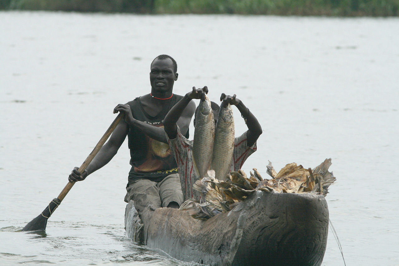
Designated as a Wetland of International Importance under the Ramsar Convention in 2006, the Sudd is a thriving aquatic ecosystem dominated by dense thickets of giant papyrus (Cyperus papyrus), tall reeds (Phragmites mauritianus), floating water hyacinths, and sprawling mats of wild rice (Oryza longistaminata). For millennia, the floating vegetative islands (sadds) of the wetland blocked foreign explorers from discovering the source of the White Nile, turning the region into a natural fortress that protected interior indigenous communities from external military incursions and nineteenth-century slave-raiding expeditions. Today, the wetland supports one of Africa’s most productive freshwater fisheries, yielding over one hundred fish species—including Nile perch, tigerfish, and lungfish—that sustain thousands of artisanal fishermen operating dugout canoes (canoes) along intricate water channels.
The geopolitical significance of the Sudd sparked one of the continent’s most controversial engineering projects: the Jonglei Canal. Conceived in the mid-twentieth century to bypass the wetland and channel millions of cubic meters of water directly to downstream agriculture in northern Sudan and Egypt, construction of the canal began in 1978. However, southern communities recognized that draining the wetland would destroy the seasonal grazing grounds (toich) essential for their cattle herds and alter the regional microclimate. In 1983, the newly formed Sudan People’s Liberation Army (SPLA) halted excavation of the canal by attacking construction machinery, leaving the giant German-built “Sarah” bucket-wheel excavator stranded in the desert clay, where its rusted frame remains an enduring symbol of ecological defense.
The Cultural Universe of the Cattle Camp
To understand social life across the plains of South Sudan, one must understand the sacred and economic centrality of cattle. Among the Dinka, Nuer, and Mundari, cattle are not treated as commercial livestock; they are the spiritual center of the universe, the bridge between ancestors and descendants, and the foundation of all social status, marriage contracts, and legal reparations. A herd of long-horned Ankole-Watusi cattle—distinguished by magnificent curved ivory horns that can span over two meters—embodies a family’s history and security. Traditional spiritual authority in Dinka society is held by the beny bith, or masters of the fishing spear, spiritual leaders believed to possess the divine power to bless cattle herds, heal the sick, mediate blood feuds, and pray for seasonal rains.
Social cohesion within pastoral communities is structured through age-set systems (ric in Dinka). Cohorts of adolescent boys undergo initiation together, receiving scarification markings across their foreheads—deep horizontal incisions made with curved razors that heal into prominent tribal scars signaling adulthood, courage, and lifelong brotherhood. Members of an age-set share responsibilities in defending the herd, negotiating grazing rights, and organizing communal hunts, creating horizontal bonds that cut across individual family lines and promote mutual defense across expansive territories.

During the dry season, young men and women move with their herds from settled village farming lands into sprawling seasonal cattle camps (wut) established on river floodplains. Daily life in a camp near Terekeka or Rumbek begins before dawn in an ethereal atmosphere of burning cow dung. Herders gather dried manure into towering mounds and ignite slow-burning smudge fires; the resulting sweet-smelling, chalk-white ash and billowing smoke envelop the camp in an protective haze that repels mosquitoes and tsetse flies. Herders rub this fine antiseptic ash across their own skin and onto the bodies of their prized beasts, protecting both cattle and humans from heat and insect-borne diseases.
Every young man in traditional pastoral society receives an initiate’s ox (known as a “personality bull” or miar), whose coat patterns and horn configurations he memorializes in elaborate epic poems and praise songs. Young men spend years training the growing horns of their favorite bulls into striking asymmetrical shapes, clipping and shaping the bone to curve forward or loop sideways. Men take their adult names from the markings of their oxen, composing verses that praise the animal’s speed, beauty, and lineage. Marriages require substantial bride wealth payments (negotiated in tens or hundreds of cattle), ensuring that livestock circulate continuously between lineages, cementing inter-clan truces, and establishing kinship networks that span hundreds of kilometers across the plains.
The Great Nile Migration and East African Biodiversity
Beyond its cultural traditions, South Sudan harbors one of the greatest wildlife spectacles remaining on planet Earth. For decades, international naturalists believed that prolonged conflict had largely wiped out large mammal populations across the country. However, pioneering comprehensive aerial wildlife surveys conducted in 2023 and 2024 by African Parks in collaboration with the South Sudan Ministry of Wildlife Conservation and Tourism revealed an astonishing biological discovery: the Great Nile Migration.
Surveying an immense wilderness corridor spanning over one hundred thousand square kilometers across Boma National Park, Bandingilo National Park, and adjacent wetlands east of the White Nile, researchers documented more than five million migrating antelopes. This monumental concentration includes approximately four million white-eared kob (Kobus kob leucotis), three hundred and fifty thousand tiang (Damaliscus lunatus tiang), three hundred thousand Mongalla gazelles, and significant populations of bohor reedbuck. This newly verified mass movement eclipses the famous Serengeti wildebeest migration in sheer numbers, making it the largest documented land mammal migration on Earth.
Following the seasonal rainfall patterns between the Ethiopian highlands and the lush floodplains of the White Nile, these vast herds traverse trackless savannahs, creating dynamic grazing lawns that maintain open grasslands and support apex predators, including lions, leopards, cheetahs, and African wild dogs. The southern reaches of the country, near the borders with Uganda and the Democratic Republic of the Congo, rise toward the mist-covered Imatong Mountains, where Mount Kinyeti reaches 3,187 meters—the nation’s highest summit. The Imatong range shelters afro-montane cloud forests harboring rare primates, giant forest hogs, and endemic plant species found nowhere else in the Nile drainage basin.
Liberation Struggles, Statehood, and the Long Road to Sovereignty
The sovereign existence of South Sudan represents the culmination of more than half a century of relentless struggle against political marginalization and cultural subjugation. During the Anglo-Egyptian Condominium era (1899–1956), British colonial administrators governed the northern and southern provinces of Sudan under separate administrative frameworks through the “Closed District Ordinance,” deliberately shielding the southern animist and Christian populations from northern Arabic and Islamic influences while failing to invest in southern civic infrastructure, schools, or healthcare. When independence was precipitously granted to a unified Sudan in 1956, power was concentrated entirely in Khartoum, sparking immediate southern resistance.

The first southern uprising, waged by the Anya-Nya guerrilla movement, lasted seventeen years until the 1972 Addis Ababa Agreement granted regional autonomy to the south. However, the unilateral abrogation of that agreement in 1983 by Khartoum—culminating in the imposition of Islamic sharia law over the non-Muslim south—ignited the Second Sudanese Civil War. Under the leadership of Dr. John Garang de Mabior, the Sudan People’s Liberation Movement/Army (SPLM/A) launched a twenty-two-year armed struggle that reshaped the geopolitics of Northeast Africa.
The devastating conflict claimed over two million lives through warfare, induced famine, and mass displacement, producing famous humanitarian epics such as the journey of the “Lost Boys of Sudan”—thousands of orphaned children who walked hundreds of miles across deserts to refugee camps in Ethiopia and Kenya. Intensive diplomatic mediation led by the Intergovernmental Authority on Development (IGAD) culminated in the signing of the Comprehensive Peace Agreement (CPA) in Naivasha, Kenya, in January 2005. The CPA established an autonomous government in Juba and guaranteed the southern populace the right to self-determination. In January 2011, millions of southern Sudanese queued for days to cast their ballots, voting by an astounding 98.83 percent margin for complete independence. On July 9, 2011, South Sudan formally joined the community of nations as the 193rd member state of the United Nations.
The Imperatives of Nation-Building: Petroleum, Agriculture, and Peace
The euphoria of statehood was soon tested by internal political rivalries and structural underdevelopment. In December 2013, political fractures within the ruling SPLM escalated into a severe multi-year civil conflict between government forces led by President Salva Kiir Mayardit and opposition movements led by Riek Machar. The conflict displaced millions and stalled vital development initiatives. In September 2018, the signing of the Revitalized Agreement on the Resolution of the Conflict in South Sudan (R-ARCSS) established a transitional unity government, ushering in an era of progressive disarmament, political consolidation, and the arduous task of drafting a permanent national constitution.
Economically, South Sudan remains heavily dependent on crude petroleum extraction in the Melut and Muglad basins of the Upper Nile and Unity states. Oil revenues account for roughly eighty-five percent of national gross domestic product and nearly all export earnings. However, because South Sudan is landlocked, every barrel of crude oil must travel through an extensive 1,600-kilometer export pipeline crossing northern Sudan to reach marine loading terminals at Port Sudan on the Red Sea. Regional geopolitical volatility in the north underscores the acute necessity of diversifying the domestic economy away from singular reliance on fossil fuels.
The greatest economic potential for South Sudan lies in its fertile arable soils. Often referred to as the potential “breadbasket of East Africa,” the country possesses over thirty million hectares of prime agricultural land, yet less than five percent is currently cultivated. In the equatorial Greenbelt of Western and Central Equatoria, abundant rainfall supports double-cropping seasons of maize, cassava, groundnuts, coffee, teak, and tropical fruits. Investing in rural feeder roads, cold-storage facilities, and modern agro-processing could transform the country from a recipient of emergency food aid into a major regional agricultural exporter feeding neighboring urban markets in Uganda, Kenya, and the Congo basin.
Navigating the complex currents of historical trauma and contemporary nation-building, the people of South Sudan maintain an unshakeable devotion to their land and ancestral identity. Along the papyrus channels of the Sudd, within the smoking hearths of the cattle camps, and across the growing avenues of Juba along the White Nile, the world’s youngest nation continues to forge its destiny through collective endurance, cultural pride, and an enduring vision of enduring peace.







Share what you know
Been there, grew up there, or know something we missed? Add a comment; corrections with a source are especially welcome.