From a mate round to the Andes, Argentina opens into a country of long distances, regional identities and unfinished arguments about land, memory and belonging.
Neighbours from Wikidata (land borders and some sea borders; only places with a page here).
FLAG & SYMBOLS
The flag and symbols of Argentina
The flag
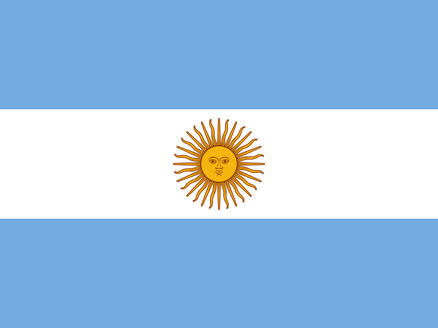
Three equal horizontal bands of sky blue (top), white, and sky blue; centered in the white band is a radiant yellow sun with a human face that is known as the Sun of May.
What it means
The colors represent the clear skies and snow of the Andes Mountains; the sun commemorates the first mass demonstration in favor of independence on 25 May 1810, when the sun broke through the clouds; the sun is designed to look like Inti, the Incan god of the sun.
Revolution Day (May Revolution Day), 25 May (1810)
Independence
9 July 1816 (from Spain)
Flag description and meaning, colours, symbols, anthem details, national day and independence: CIA World Factbook (public domain). Coat of arms, motto and recording: Wikidata and Wikimedia Commons (credited above). Flag artwork: flag-icons (MIT), retrieved 1 November 2026.
UNESCO WORLD HERITAGE
12 World Heritage Sites in Argentina
6 Cultural5 Natural3 shared with other countriesFirst listed 1981 · latest 2023
Sites, years and types: the UNESCO World Heritage List via Wikidata, retrieved 1 November 2026; ordered by year listed. Names link to English Wikipedia, or to the UNESCO page when there is no article.
The Landlore · 1083 words · 5 min read · Reviewed 2026-11-07
In Argentina, a cup of mate often travels from hand to hand. One person pours the hot water, another drinks, and the gourd comes back to the person serving. The ritual is familiar in many parts of the country, but it does not make every household or region the same. That is a useful way into Argentina: a shared practice opens a conversation, while the country around it keeps widening. From subtropical forest and river islands to the Andes, the pampas and Patagonia, Argentina is a place of great distances, layered identities and arguments about who gets to shape the national story.[1][2][13]
The map stretches along the South Atlantic and the spine of the Andes. In the northeast, the province of Misiones is green, humid and close to Paraguay and Brazil; the Iguazú River forms part of Argentina’s border with Brazil before plunging over the falls. Across the centre, the Pampas open into plains of grassland and cultivated fields. Farther west, the Andes rise between Argentina and Chile, while the dry valleys and high plateaus of the northwest hold older routes and settlements. Patagonia occupies the south: a vast region of plateaus, steppe, lakes, forests, mountains and a long Atlantic shore. These are not interchangeable backdrops. Climate, distance and access to water shape work, travel and the feel of everyday life differently in each.[1][3]
The argument over memory
Argentina’s recent history includes an era that still shapes how people speak about power and justice. A military dictatorship ruled from 1976 to 1983 and carried out a systematic campaign of kidnapping, torture and enforced disappearance. The former Navy Mechanics School in Buenos Aires, known as ESMA, was one of the clandestine detention centres used by the regime. It is now a museum and site of memory, preserved as evidence of state violence and as a place where visitors encounter testimony and the work of remembrance. The return to civilian government did not erase the damage. Families continue to seek truth about the disappeared, and public argument about the dictatorship remains part of national life.[16][17]
Memory is also made in public squares and courts. The Mothers and Grandmothers of Plaza de Mayo began organizing during the dictatorship to demand information about disappeared relatives and children taken from detained parents. Their weekly presence in the square became a visible insistence that the state answer for what it had done. Later trials and memory institutions have continued that work, with evidence preserved in archives, testimony and former detention sites. This history is not a completed chapter kept behind museum glass. It remains a way Argentines debate democracy, responsibility and the rights of families to know what happened.[17][20]
Economic life adds another layer to the national conversation. Argentina has fertile agricultural regions, mineral resources, energy production, manufacturing, technology and a large service sector. These sources of wealth connect the country to global markets, but they do not guarantee stability or an equal distribution of opportunity. Repeated inflation and debt crises have affected household decisions, savings and public trust; the country’s economic direction is frequently contested between voters, governments, provincial interests and lenders. To understand Argentina, it helps to see both the productive capacity of its land and people and the uncertainty that can shape an ordinary family’s plans. This tension is part of current life, not a flaw that defines the country.[18]
What the distances hold
Argentina does not resolve into a single scene. The broad plains and cattle country are real, as are the port-city tango, the shared mate round and the glacier-fed lakes of Patagonia. But they sit beside Andean Indigenous communities, subtropical forests, river towns, migrant neighbourhoods and places where national memory remains unfinished. The country is held together by roads, rivers, language, shared institutions and arguments about land and power, while its regions keep their own histories and ways of speaking.
In Santa Cruz, the Perito Moreno Glacier advances from the Southern Patagonian Ice Field into Lago Argentino. Photo: Diego Delso / Wikimedia Commons · CC BY-SA 3.0
Begin with the mate, if you like: a small invitation that asks you to wait, take your turn and notice who is passing the cup. Then let Argentina grow beyond the ritual. Follow the Paraná north, cross the plains, listen for the changes in Spanish, and travel west until the Andes form the horizon. Each distance opens onto another way of living in the same country—and another reason to keep learning its names.
Atlas Inquiry: key geographic and cultural questions
Why does the Perito Moreno Glacier regularly form a natural ice dam?
The Perito Moreno Glacier flows down from the Southern Patagonian Ice Field into Lake Argentino, advancing across the Brazo Rico channel until it presses against the opposite shore on the Península de Magallanes. This wall of ice creates a natural dam that cuts off the lake’s southern arm from its primary outlet. Trapped meltwater in Brazo Rico rises several metres above the main lake, generating immense hydrostatic pressure. Eventually, the trapped water undercuts the glacier base, carving a tunnel that collapses dramatically.
What environmental conditions distinguish the Pampas grasslands?
The Pampas encompass an expansive lowland plain of deep, fertile loess and alluvial soils, shaped by temperate maritime and continental air interactions. Rainfall decreases steadily from the humid coastal margins in the east to the semi-arid dry pampa in the west. Strong, cold southwesterly winds known as pamperos sweep across the flat terrain, producing rapid temperature drops. Historically dominated by tall tussock grasses without native tree cover, this vast biome has been largely transformed into pasture for cattle and fields for soy.
How did the Andean Qhapaq Ñan road network integrate northwestern valleys?
Northwestern territories formed the southern frontier of the Inca Empire, or Collasuyu, connected by the monumental stone highway known as the Qhapaq Ñan. Mountain roads traversed valleys like the Quebrada de Humahuaca and the Calchaquí Valleys, linking mineral mines, agricultural terraces, and fortified hill posts called pucarás. Inca administrators established tambo waystations a day’s march apart to store dried llama meat and grain, facilitating rapid messenger transit and imperial tax collection across altitudes reaching above 4,000 metres.
What cultural significance does mate tea hold in daily social interaction?
Mate is an infusion brewed from the dried leaves of the yerba mate tree, Ilex paraguariensis, consumed from a hollowed gourd through a metal straw called a bombilla. Drinking mate is an entrenched social ritual governed by strict communal etiquette. A single host, the cebador, prepares the gourd, tests the first pour, and passes it clockwise around the gathered circle. Each participant drinks the full serving before returning the vessel without saying thanks until they have completed their portion.
We are building an open, source-backed atlas of every country, region, ocean and culture — combining verified geographic data with long-form cultural storytelling.
Names and immediate parent assignments: GeoNames, CC BY 4.0, 28 October 2026. Unspecified code 00 excluded. This is not an exhaustive list of districts, counties or municipalities. Photographs are credited individually beneath each image; one pictured place does not represent every landscape in its region.
FROM THE JOURNAL
Stories from Argentina
Our editorial journey here is still ahead. No researched stories have been published for this place yet.












Share what you know
Been there, grew up there, or know something we missed? Add a comment; corrections with a source are especially welcome.