Cameroon brings Atlantic coast, rainforest, highlands, savannah and Sahel into one multilingual republic whose regional histories still shape debates over representation.
Neighbours from Wikidata (land borders and some sea borders; only places with a page here).
FLAG & SYMBOLS
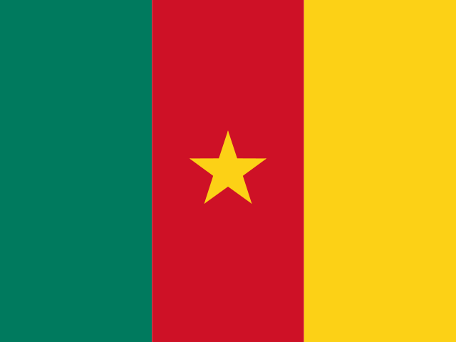
The flag and symbols of Cameroon
The flag
Three equal vertical bands of green (left side), red, and yellow, with a small five-pointed yellow star centered in the red band.
What it means
Red stands for unity; yellow for the sun, happiness, and the northern savannahs; green for hope and the southern forests; the star is called the "star of unity;" the vertical tricolor design is similar to the French flag.
"O Cameroun, Berceau de Nos Ancêtres" (O Cameroon, Cradle of Our Forefathers) Rene Djam Afame, Samuel Minkio Bamba, Moise Nyatte Nko'O [French], Benard Nsokika Fonlon [English]/Rene Djam Afame
National day
State Unification Day (National Day), 20 May (1972)
Independence
1 January 1960 (from French-administered UN trusteeship)
Flag description and meaning, colours, symbols, anthem details, national day and independence: CIA World Factbook (public domain). Coat of arms, motto and recording: Wikidata and Wikimedia Commons (credited above). Flag artwork: flag-icons (MIT), retrieved 1 November 2026.
UNESCO WORLD HERITAGE
3 World Heritage Sites in Cameroon
1 Cultural2 Natural1 shared with other countriesFirst listed 1987 · latest 2025
Sites, years and types: the UNESCO World Heritage List via Wikidata, retrieved 1 November 2026; ordered by year listed. Names link to English Wikipedia, or to the UNESCO page when there is no article.
The Landlore · 1351 words · 7 min read · Reviewed 2026-11-08
One country, many climates
Mount Cameroon rises above the Gulf of Guinea, while the country’s northern edge reaches the semi-arid lands beside Lake Chad. Between these far-apart horizons, forest, volcanic highlands, savannah and broad river plains shape different seasons of work and food. No one landscape can stand for the whole country; Cameroon’s story begins in the distances between them, and in the effort to hold many regional histories within one republic.[1][reference needed]
In the southwest, Mount Cameroon rises above the Atlantic coast to more than four thousand metres as an active volcano. Its wet seaward slopes feed rivers, montane forest and lowland plantations around Buea and Limbe. The western highlands and grassfields hold cooler volcanic soils, crater lakes and densely settled farming country. Farther east and south, the Southern Cameroon Plateau and equatorial rainforest extend toward the Central African Republic, Gabon and the Republic of the Congo. Moving north across the Adamawa Plateau—often called the country’s watershed because major rivers rise along its heights—wooded savanna gives way to the dry plains of the Far North beside the Logone floodplain and Lake Chad. Four main drainage basins carry Cameroon’s waters in opposite directions: Atlantic coastal rivers such as the Sanaga and Wouri, the Congo tributary system in the southeast, the Niger basin via the Benue, and the Lake Chad basin. Roads and railways tie the port of Douala and the deepwater terminal at Kribi to inland towns and landlocked neighbours.[1][reference needed][3]
The volcanic slopes of Mount Cameroon rise above Buea near the Gulf of Guinea coast. Photo: Adesolive / Wikimedia Commons · CC BY-SA 4.0
Those ecological differences shape agriculture and rural work. Cocoa, rubber, bananas and oil-palm cultivation are closely associated with the humid south and coastal plains; arabica and robusta coffee, potatoes, beans, plantains and market vegetables are grown across the western highlands; cotton, groundnuts, onions, sorghum and millet anchor farming in the drier north, alongside transhumant cattle herding on the Adamawa and northern plains. These are broad regional patterns rather than a rigid formula for every village. Cameroon’s smallholders and agro-industrial estates work with contrasting soils, bimodal or single rainy seasons, and uneven road access to urban buyers. A 2026 World Bank agricultural initiative highlights how improving irrigation, storage and feeder roads in agropastoral and fishing zones can raise incomes and steady domestic food supplies when drought or flooding strikes.[1][3][4]
Food and culture follow local routes
Cameroonian food changes with the growing zones and market corridors. In the coastal Douala region, ndolé combines washed bitter leaves with groundnuts and spices. Cooks simmer it with fish, shrimp or beef and serve it with ripe plantains, bobolo (fermented cassava batons wrapped in leaves) or rice. In the South-West, finely shredded eru forest leaves are cooked with palm oil, smoked fish, crayfish and cowskin and eaten with water fufu or garri. In the West and North-West, dishes such as koki (steamed black-eyed pea pudding wrapped in banana leaves) and achu (pounded cocoyam with yellow palm-oil soup) draw on highland harvests. Across northern towns such as Garoua and Maroua, millet or sorghum paste is paired with okra or baobab-leaf sauces, while roadside grills roast spiced beef skewers known as soya and wholechargrilled fish in coastal towns. A World Intellectual Property Organization study notes how producers in Moungo protect Penja white pepper, grown in rich volcanic soil under geographical-indication rules. Each dish carries the ecology of its home region into city kitchens.[16][17]
On the coast, Sawa communities in Douala hold the Ngondo, a ceremony and cultural gathering associated with water oracles and the Wouri River. At the sacred gathering on the Wouri, a priest leaves in a canoe carrying a vase with the community’s wishes and grievances, then dives into the river. The message brought back is interpreted as guidance from the water spirits, alongside canoe races, choral singing and traditional wrestling on the sandbanks. Inscribed by UNESCO in 2024, the rite is one part of an annual gathering of coastal Duala and related Sawa peoples rather than a ceremony shared by all Cameroonians. On the Wouri, the river is part of a coastal community’s account of its relationship with the living, the ancestors and the Atlantic.[18]
Popular music gives another view of the country’s urban cultural life. Makossa developed in Douala from a Duala dance tradition and absorbed highlife, rumba and jazz influences arriving through the port. It gained international reach through saxophonist Manu Dibango and generations of bassists and singers. Bikutsi grew from Beti and Ewondo women’s rhythmic songs and balafon ensembles in central and southern provinces, later electrified with guitars and brass in Yaoundé nightclubs. In the grassfields and coastal southwest, bensikin, mbolé and Cameroonian hip-hop and afropop sung in French, English, Pidgin and Frananglais add younger urban registers. These nationally familiar styles belong to a wider musical field that includes northern praise singing, church choirs and community festivals.[14][21]
Douala and Yaoundé show two different kinds of national centre. Douala is the largest city, main seaport and industrial hub. It sits along the Wouri estuary, where bridges, docks and rail yards move cocoa, coffee, timber, cotton and manufactured goods between the interior and overseas ships. Landlocked Chad and the Central African Republic also rely on Douala and the southern port of Kribi for much of their maritime trade. Yaoundé, in the Centre, is the political capital. Its ministries, embassies and public universities spread across seven forested hills inland. Regional capitals such as Bafoussam, Bamenda, Bertoua, Ngaoundéré, Garoua and Maroua connect rural producers and cross-border markets to those two metropolitan poles. In Ngaoundéré, the railway from Yaoundé ends at a busy northern freight and passenger station where road hauliers load goods bound for Garoua, Maroua, N’Djamena and Bangui. That link between coastal port, highland crossroads and northern railhead explains why roads and bridges matter so intensely to households and businesses across all ten regions.[reference needed][13][19]
The bridge over the Wouri River connects neighbourhoods and trade routes in the coastal port city of Douala. Photo: Happiraphael / Wikimedia Commons · CC BY-SA 4.0
Atlas Inquiry: key geographic and cultural questions
What causes rare limnic eruptions in crater lakes like Lake Nyos?
Lake Nyos is a deep crater lake formed within an extinct volcanic maar along the Cameroon Volcanic Line. Magma chambers miles beneath the lake floor continually seep carbon dioxide gas into deep groundwater, which dissolves into bottom water layers under immense hydrostatic pressure. Because the tropical lake does not experience seasonal temperature turnover, the bottom water remains stratified and supersaturated with dissolved gas. In August 1986, a landslide or sudden geological disturbance triggered rapid degassing, releasing a cloud of carbon dioxide that asphyxiated over 1,700 people in surrounding valleys.
Why is Cameroon frequently described as Africa in miniature?
The moniker Africa in miniature reflects the nation’s exceptional ecological and geographic diversity, which encompasses virtually all major climate zones of the African continent. The south features coastal Atlantic mangroves and dense equatorial rainforests of the Congo Basin. The central interior rises into the rolling volcanic plateau of the Adamaoua, characterized by humid savannas and cattle grazing. Further north, the landscape transitions through semi-arid Sahelian scrub to the dry shores of Lake Chad, providing a condensed cross-section of African biomes within a single sovereign territory.
How did King Njoya of the Bamum Kingdom develop an indigenous writing system?
In the late 1890s, Sultan Ibrahim Njoya of the Bamum Kingdom recognized that preserving his people’s history and royal diplomacy required an independent written language. He created the Shu-mom script, initially utilizing over four hundred pictographic signs before refining it into an eighty-letter syllabary. Njoya used this indigenous writing system to transcribe epic royal chronicles, legal codes, pharmacological remedies, and map surveys. He also established royal printing presses and founded schools in Foumban to teach the script, creating one of Africa’s indigenous nineteenth-century literary traditions.
How does the dual colonial heritage of English and French influence national administration?
Following the defeat of German imperial forces in the First World War, the League of Nations partitioned German Kamerun into British and French mandates. The larger eastern territory fell under French administration, while the western strip was administered by Britain alongside Nigeria. Upon reunification in 1961, the country adopted both French and English as official languages, maintaining separate educational, administrative, and legal systems—civil law in the Francophone regions and common law in the Anglophone southwest and northwest. This structural division remains a central dynamic in contemporary governance.
Sources & credits22 references +
Written sources
Cameroon at a glanceFood and Agriculture Organization of the United Nations · Accessed 2026-11-08↩
Overview of CameroonHigh Commission of Cameroon in Canada · Accessed 2026-11-08
We are building an open, source-backed atlas of every country, region, ocean and culture — combining verified geographic data with long-form cultural storytelling.
Names and immediate parent assignments: GeoNames, CC BY 4.0, 28 October 2026. Unspecified code 00 excluded. This is not an exhaustive list of districts, counties or municipalities. Photographs are credited individually beneath each image; one pictured place does not represent every landscape in its region.
FROM THE JOURNAL
Stories from Cameroon
Our editorial journey here is still ahead. No researched stories have been published for this place yet.












Share what you know
Been there, grew up there, or know something we missed? Add a comment; corrections with a source are especially welcome.