


Spanning the volcanic backbone and freshwater lowlands of the Central American isthmus, the Republic of Nicaragua is a nation shaped by geological fury, sweeping inland waters, colonial rivalries, and poetic distinction. Bordered by Honduras to the north and Costa Rica to the south, the country links the wave-swept rollers of the Pacific Ocean to the mangrove lagoons, reef shoals, and rainforest delta reaches of the western Caribbean Sea. Across its 130,373 square kilometers of territory, Nicaragua holds the largest surface area of any Central American republic, defined above all by the great tectonic trough of the Nicaraguan Depression, where freshwater inland seas mirror the smoking cones of the Maribios volcanic chain.
The geographic soul of Nicaragua is divided into three distinct realms: the Pacific coastal lowlands with their string of nineteen active and dormant volcanoes; the central mountainous interior of forested cordilleras, misty cloud forests, and shade-grown coffee valleys; and the vast, sparsely populated Caribbean slope, historically known as the Mosquito Coast, drained by sluggish jungle rivers into saltwater lagoons. This environmental tripartite division has driven distinct histories, linguistic boundaries, and economic pathways across centuries, producing a territory where Hispanic Pacific cities and Afro-Indigenous Caribbean communities coexist within a single sovereign republic.
The Volcanic Rift Zone
Western Nicaragua sits squarely on the destructive boundary where the oceanic Cocos Plate subducts beneath the Caribbean Plate, driving deep crustal melting that feeds the Central American Volcanic Arc. Running parallel to the Pacific coastline from the Gulf of Fonseca in the northwest to the borderlands of Costa Rica in the southeast, this chain of volcanic cones forms an imposing geographic rampart. Strung along this axis are some of Central America’s most dynamic peaks, including San Cristóbal—the country’s highest volcano at 1,745 meters—Telica, Cerro Negro, Momotombo, and the legendary Masaya caldera.
Cerro Negro, formed abruptly in 1850 in a violent basaltic cinder eruption, remains one of the youngest volcanic vents in the Americas, its stark black slopes devoid of vegetation offering a dramatic contrast against the surrounding green farmland of the León department. Further southeast near Lake Managua, Momotombo rises with near-perfect conical geometry. Its historic 1610 eruption showered ash and triggered devastating earthquakes that buried and destroyed the original Spanish colonial settlement of León Viejo, prompting survivors to rebuild their city thirty kilometers to the west.
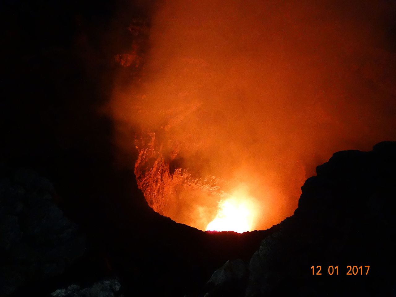
South of modern Managua lies the Masaya caldera complex, a vast basaltic shield volcano that has captivated and terrified observers for millennia. To the pre-Columbian Chorotega and Nicarao peoples, the steaming Santiago crater was a sacred portal inhabited by deities, where priests offered sacrifices during severe droughts. Spanish friars arriving in the sixteenth century viewed the degassing abyss with superstitious dread, naming it La Boca del Infierno (The Mouth of Hell) and planting an exorcism cross atop the rim to keep evil spirits contained. Today, Masaya remains an active open-vent degassing volcanic laboratory, its persistent plume of sulfur dioxide trailing across the Pacific plains under the watch of volcanologists.
The Inland Seas: Cocibolca and Xolotlán
Beyond the volcanic ridge lies the massive tectonic rift basin containing the two great freshwater bodies of Central America: Lake Managua (Lake Xolotlán) and Lake Nicaragua (Lake Cocibolca). Spanning approximately 8,264 square kilometers, Lake Nicaragua is the nineteenth largest lake on Earth and the largest body of freshwater between Lake Michigan and Lake Titicaca. The indigenous Nahuatl-speaking settlers named it Cocibolca, meaning ‘sweet sea,’ in recognition of its oceanic proportions, violent afternoon squalls (known as el papagayo), and horizon-spanning water expanses.
Cocibolca is renowned for its remarkable freshwater fauna, most famously the bull shark (Carcharhinus leucas), which historically migrated up the ninety-meter rapids and falls of the San Juan River from the Caribbean Sea, adapting to spend months within the lake’s freshwater depths. The lake also supports sawfish, tarpon, and numerous endemic cichlid species that have evolved specialized ecological niches within the lake’s diverse bottom topographies.

Rising dramatically from the center of Lake Nicaragua is Ometepe Island, whose hourglass shape is formed by two volcanoes joined by a low, swampy isthmus called Istián. In the northwest, Volcán Concepción rises to 1,610 meters as a symmetrical, active stratovolcano crowned by wisps of steam and ringed by rich agricultural terraces cultivating plantains and sesame. To the southeast, the dormant Volcán Maderas rises to 1,394 meters, cloaked in dwarf cloud forests and concealing an emerald freshwater crater lagoon at its summit. Ometepe preserves one of Central America’s densest concentrations of pre-Columbian petroglyphs and carved basalt basaltic statues, left by ancient migratory peoples who considered the volcanic island a sanctuary promised by prophecy.
Near the lake’s northwestern shoreline lies Las Isletas de Granada, an archipelago of 365 small volcanic islands formed more than twenty thousand years ago when an explosive avalanche from nearby Mombacho volcano collapsed into the water. Today, these miniature islands support fishing communities, eco-lodges, and roosting colonies of egrets, cormorants, and kingfishers, creating a tranquil labyrinth between the colonial city of Granada and the open waters of Cocibolca.
Colonial Foundations, Poetry, and Urban Rivalry
Spanish colonization of Nicaragua commenced in 1524 under Francisco Hernández de Córdoba, who established two foundational cities that would shape the political identity of the territory for four centuries: Granada on the shores of Lake Nicaragua, and León on the western margins near the Pacific. Granada, with its direct lake access and navigable outlet to the Caribbean via the San Juan River, emerged as an aristocratic, merchant stronghold allied with royalist interests and conservative politics. León, established near major indigenous settlements and surrounded by fertile volcanic soils, developed as an intellectual and university center favoring liberal, secular ideologies.
The bitter rivalry between León and Granada defined the post-independence nineteenth century, plunging Nicaragua into repeated civil conflicts that left the country vulnerable to foreign intervention. This political chaos reached a climax in 1855 when the American filibuster William Walker invaded Nicaragua with an armed mercenary force, captured Granada, and declared himself president, attempting to establish an English-speaking slave territory. An allied Central American army defeated Walker in 1857, but not before his retreating troops set fire to Granada, leaving behind a sign reading Aquí fue Granada (‘Here stood Granada’).

In León, intellectual life centered around the monumental Real e Insigne Basílica Catedral de la Asunción de la Bienaventurada Virgen María, inscribed by UNESCO as a World Heritage site. Constructed between 1747 and the early nineteenth century, the cathedral is the largest religious structure in Central America. Its low, thick-walled proportions, square bell towers, and subterranean vaulted crypts were engineered to withstand the severe seismic shocks common along the Maribios volcanic belt. On its gleaming white rooftop, visitors walk across brick terraces and cupolas that overlook the city’s red-tiled roofs and distant volcanic cones.
Inside León Cathedral rests the marble tomb of Nicaragua’s most celebrated son, Félix Rubén García Sarmiento, known globally as Rubén Darío (1867–1916). Darío revolutionized Spanish-language literature by founding the Modernismo movement, a poetic renaissance that synthesized French Parnassian and Symbolist styles with Latin American themes, transforming Spanish prosody and rhythmic expression on both sides of the Atlantic. Darío’s literary mastery made poetry an enduring point of national pride in Nicaragua, where it is often remarked that every citizen is an author, poet, or guitar player until proven otherwise.
To end the destructive nineteenth-century wars between León and Granada, the government designated Managua as the permanent national capital in 1852. Situated equidistant between the two rivals along the southern shore of Lake Xolotlán, Managua grew from a modest fishing settlement into an administrative metropolis. The city’s history has been repeatedly marked by seismic tragedy, most catastrophically on the night of December 23, 1972, when a magnitude 6.2 earthquake struck the city center, killing an estimated ten thousand people and flattening hundreds of commercial blocks. Rather than rebuilding the old grid, the city rebuilt outward into a decentralized urban sprawl, leaving the ruined shell of the Old Cathedral of Santiago standing as an open-air monument to natural disaster.
Northern Highland Terraces and Mountain Valleys
North and east of the Pacific volcanic depression, the landscape rises into the rugged Cordillera Isabelia and Cordillera Dariense, forming the northern highlands of Matagalpa, Jinotega, Estelí, and Madriz. Here, elevations climb above 1,500 meters at peaks such as Mogotón (2,107 meters) on the Honduran border, creating temperate microclimates marked by cool nights, morning mountain mists, and pine-oak woodlands.
The departments of Jinotega and Matagalpa form the heart of Nicaragua’s premium coffee production. Introduced in the mid-nineteenth century, Arabica coffee thrives under the canopy of native shade trees on steep mountain slopes, where volcanic soil minerals and consistent rainfall produce beans prized internationally for their balanced acidity, chocolate undertones, and citrus notes. The coffee harvest, running from November through March, brings thousands of pickers into mountain estates, shaping seasonal rural commerce and family livelihoods.
The northern highlands also possess distinct artisan traditions. In the town of San Juan de Oriente near Masaya, indigenous potters preserve pre-Columbian ceramic techniques, using mineral slips and stone burnishers to create complex geometric vessels. Further north in Estelí, skilled master blenders and rollers have established one of the world’s most prestigious premium cigar manufacturing centers, utilizing Cuban-seed tobacco grown in the fertile alluvial soils of the surrounding valley. In Matagalpa and Jinotega, indigenous groups including the Cacaopera and Matagalpa maintain ancestral agricultural knowledge, cultivating heirloom varieties of maize, beans, and medicinal forest herbs.
Mosquitia and the Caribbean Lowlands
Encompassing more than half of Nicaragua’s landmass, the Caribbean lowlands present a stark contrast to the Pacific and highland regions. Covered by dense rainforests, mangrove swamps, and broad river valleys, this humid frontier was historically isolated from the central government in Managua. Politically, it is divided into two autonomous regions: the North Caribbean Coast Autonomous Region (RACCN) and the South Caribbean Coast Autonomous Region (RACCS), established under the 1987 Autonomy Statute to preserve indigenous and Afro-descendant governance.
During the colonial era, the Spanish Empire failed to establish permanent control over this eastern territory, allowing the indigenous Miskito people to form a strategic military alliance with English privateers and British colonial authorities in Jamaica. Between the seventeenth and nineteenth centuries, Britain recognized the Kingdom of Mosquitia as an independent protectorate governed by a Miskito monarch, creating an English-speaking, Protestant cultural sphere completely distinct from Spanish, Catholic western Nicaragua. Great Britain officially ceded its claims over the coastline under the Treaty of Managua in 1860, and President José Santos Zelaya formally incorporated the territory by military force in 1894.
Today, the Caribbean coast is a rich multilingual mosaic. The Miskito, Mayangna (Sumo), and Rama indigenous peoples live alongside Afro-descendant Creole and Garifuna communities. In the port city of Bluefields and the idyllic offshore Corn Islands (Big Corn and Little Corn), English-based Creole is the primary spoken tongue, alongside Miskito and Spanish. The offshore Corn Islands, surrounded by clear turquoise waters and thriving coral barrier reefs, remain key centers for spiny lobster and artisanal fishing, as well as marine conservation.
The Caribbean watershed is nourished by immense waterways, including the Coco River (Wangki), which forms the border with Honduras, the Grande de Matagalpa, and the San Juan River. Running along the southern boundary from Lake Nicaragua to the Caribbean, the San Juan River traverses the vast Bosawás and Indio Maíz Biosphere Reserves. Bosawás, covering more than two million hectares, forms the second-largest tract of tropical rainforest in the Western Hemisphere after the Amazon, serving as a critical biological corridor for tapirs, jaguars, harpy eagles, and green macaws.
Gastronomy, Syncretism, and Community Life
Nicaraguan culinary identity is deeply rooted in maize, which the Chorotega and Nicarao peoples cultivated for millennia as a sacred gift of the gods. The national foundation is gallo pinto, a dish of red silk beans and long-grain rice fried together with onions, bell peppers, and garlic, consumed daily from breakfast to late-night suppers. On Sundays, families gather across towns and villages for nacatamales, large parcels of corn masa enriched with pork belly or chicken, potatoes, rice, tomatoes, olives, and fresh mint, wrapped in plantain leaves and steamed over wood fires for hours.
Street food culture flourishes around traditional snacks like quesillo—a tender coil of soft, unpasteurized cow’s milk cheese wrapped in a warm corn tortilla, smothered in pickled minced onions and rich sour cream, and eaten from a clear plastic bag—and vigorón, a hearty combination of boiled yuca root, crispy pork cracklings (chicharrón), and a sharp salad of shredded cabbage and mamey chilies, traditionally served on green banana leaves in the central square of Granada.
Religious expression in Nicaragua exhibits a deep syncretism between Roman Catholic devotions and indigenous festive theater. The most striking manifestation is the annual celebration of Santo Domingo de Guzmán in Managua, where thousands of pilgrims dance through the streets coated in black motor oil or red paint, honoring ancestral protective spirits under the guise of the Catholic saint. In León and Granada, the celebration of La Purísima in early December honors the Immaculate Conception with the Gritería, an exuberant evening where neighborhoods echo with the shout: ¿Quién causa tanta alegría? ¡La Concepción de María! (‘Who causes so much joy? The Conception of Mary!’), accompanied by the distribution of sugarcane, sweet lemons, and traditional pastries.
The cultural pinnacle of Nicaraguan folk theater is El Güegüense (The Wise Man), an anonymous seventeenth-century satirical street drama inscribed by UNESCO on the Representative List of the Intangible Cultural Heritage of Humanity. Performed during the patron saint festivities of Diriamba in Carazo, El Güegüense combines rhythmic flute and drum music, wooden masks, and multilingual dialogue in Nahuatl and Spanish. The play tells the humorous story of an indigenous elder who outwits colonial Spanish tax collectors and royal authorities through cunning wordplay, irony, and passive non-compliance, remaining a powerful national symbol of grassroots resistance and wit.
Economic Trajectories and Contemporary Realities
Nicaragua’s economy remains fundamentally tied to its agricultural base, which accounts for a substantial share of national employment and export earnings. Key export commodities include coffee, beef, sugar, gold, peanuts, and dairy products. In recent decades, the country has also developed an extensive light manufacturing and textile export sector (maquiladoras) clustered in free trade zones around Managua and the western plains, benefiting from preferential access under the Dominican Republic–Central America Free Trade Agreement (CAFTA-DR).
The country has also made significant strides in transforming its domestic energy matrix. Exploiting its dynamic tectonic setting, Nicaragua has invested heavily in geothermal energy, drawing high-temperature steam from the slopes of the Momotombo and San Jacinto-Tizate volcanic complexes. Combined with wind farms situated along the blustery southern shores of Lake Nicaragua, run-of-river hydroelectric stations in the northern cordilleras, and biomass generation from sugar cane processing, renewable resources now generate over seventy percent of the nation’s electric power, reducing reliance on imported fossil fuels.
Despite these ecological and energetic endowments, Nicaragua faces enduring social and economic hurdles. It remains one of the lowest-income countries in Latin America, with substantial income disparities between the urbanized Pacific corridor and the historically neglected Caribbean regions. Emigration to Costa Rica, the United States, and Spain represents a vital financial lifeline, with annual migrant worker remittances providing critical household income for food, education, and healthcare across thousands of families.
Furthermore, climate vulnerability poses an ongoing risk to agricultural stability. Situated in the Central American Dry Corridor, the western and northern departments regularly experience severe droughts associated with El Niño weather patterns, followed by devastating tropical storms and hurricanes originating in the Caribbean. In 1998, Hurricane Mitch caused catastrophic landslides on the slopes of the Casita volcano that buried entire farming communities, leaving deep scars across the northwest. Adapting farming systems to erratic rainfall, restoring degraded forest watersheds in the upper cordilleras, and safeguarding the precious freshwater ecology of Lake Nicaragua remain paramount imperatives for the country’s collective future.
Nicaragua endures as an evocative crossroads, where the subterranean heat of nineteen volcanoes meets the serene majesty of inland seas, where the classical cadence of modernist verse echoes through colonial plazas, and where indigenous resilience continues to guide everyday life across mountain valleys and tropical coasts.








Share what you know
Been there, grew up there, or know something we missed? Add a comment; corrections with a source are especially welcome.