
On 23 January 1960, Swiss oceanographer Jacques Piccard and United States Navy Lieutenant Don Walsh peered through a conical Plexiglas porthole into total darkness nearly eleven kilometres beneath the ocean surface. Their vessel, the bathyscaphe Trieste, had settled onto a soft diatomaceous ooze at the bottom of Challenger Deep within the Mariana Trench.[reference needed][reference needed] Over one thousand atmospheres of hydrostatic pressure bore down upon the spherical forged-steel cabin. Through the dark water outside, illuminated briefly by mercury vapor floodlights, they recorded an ivory-white flatfish and a small red shrimp stirring the silt. Life persisted where physical intuition suggested the cold and crushing weight would extinguish biological function.[reference needed][reference needed]
Above the floor of Challenger Deep stretches the Pacific Ocean, the largest physical feature on our planet. Encompassing approximately 165 million square kilometres, the Pacific covers more surface area than all of Earth’s terrestrial landmasses combined.[reference needed] It extends from the ice-choked waters of the Bering Strait in the subarctic south to the frozen rim of Antarctica. It stretches across nearly half the globe from the western shores of the Americas to the continental margins of China, Japan, and Australia.[reference needed] Its basin is defined by dynamic mechanical forces. Subducting tectonic plates generate volcanic island arcs. Sweeping wind-driven ocean gyres stir surface waters. Deep thermohaline water masses circulate on centuries-long cycles.
The deep edge of the western basin
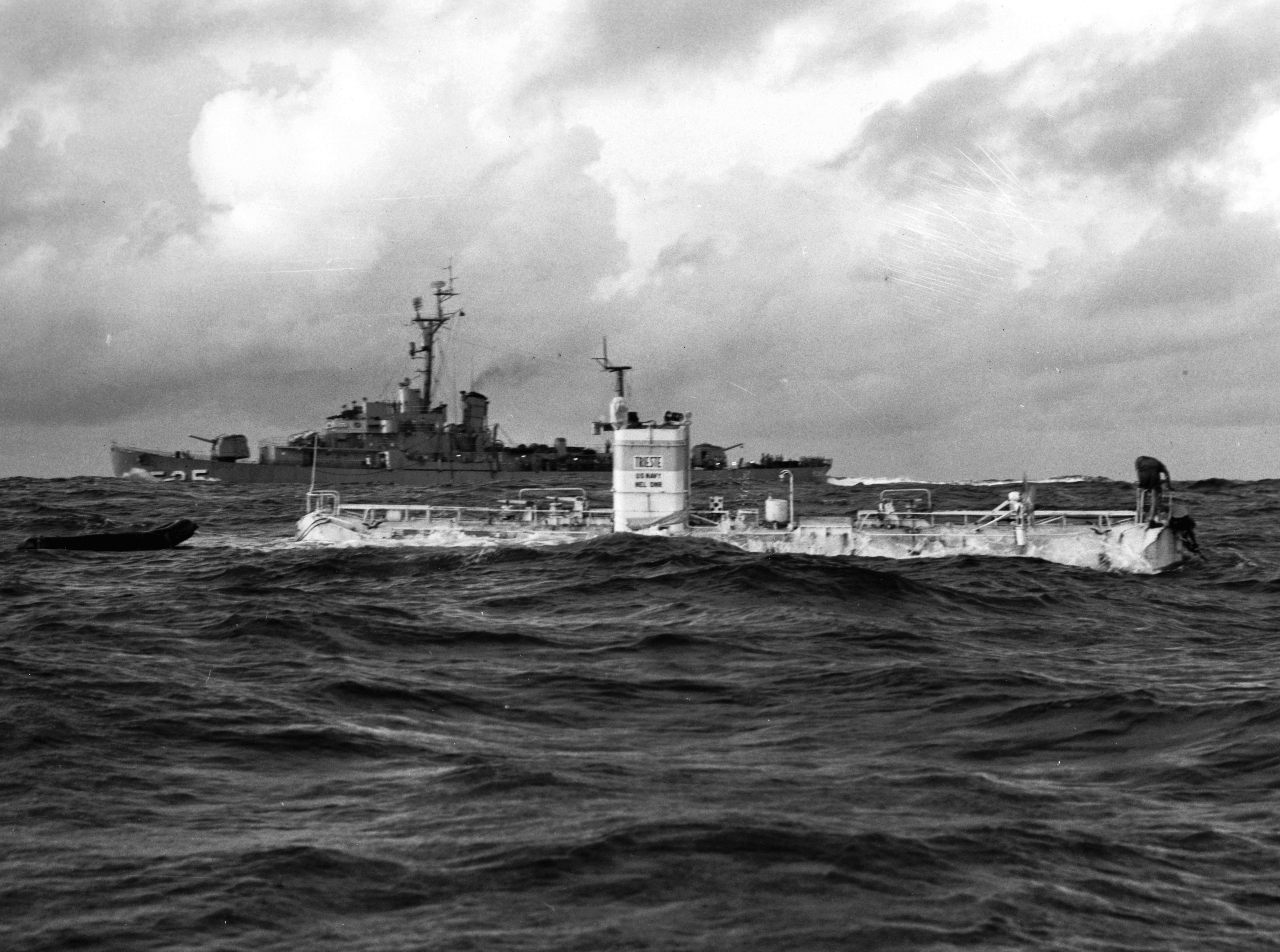
The Mariana Trench represents the tectonic terminus where the ancient, dense Pacific Plate plunges steeply beneath the younger Philippine Sea Plate.[reference needed] This subduction zone curves for roughly 2,550 kilometres through the western ocean. It forms a crescent-shaped scar that drops sharply from the abyssal seafloor into the hadal realm. At depths below six thousand metres, the hadal zone represents an isolated archipelago of trenches. Here hydrostatic pressure exceeds one thousand kilograms per square centimetre. Temperatures hover barely above freezing.[reference needed]
For decades, oceanographers considered hadal trenches to be biological deserts starved of organic nutrients. Recent deep-sea sampling and autonomous lander deployments have overturned that assumption. Organic matter, marine snow, and decaying detritus from surface waters drift downward. The steep V-shaped topography funnels this material into the trench axis like sediment down a chute.[reference needed] This accumulated organic cache sustains dense populations of endemic hadal amphipods, sea cucumbers, and specialized snailfish. To withstand pressures that would rupture ordinary cell membranes, these organisms accumulate high concentrations of piezolytes. These small organic osmolyte molecules stabilize enzymes and preserve cellular architecture under intense mechanical stress.[reference needed]
Along the shallower flanks of the western Pacific plate boundaries, tectonic subduction gives rise to the Pacific Ring of Fire. This contiguous horseshoe-shaped belt holds approximately seventy-five percent of the world’s active volcanoes and ninety percent of its earthquakes.[reference needed] Seawater circulates deep into fractured oceanic crust, superheats near magma chambers, and vents back into the abyss as mineral-laden hydrothermal fluids. These black smoker chimneys discharge iron, copper, and zinc sulfides at temperatures exceeding three hundred degrees Celsius. They host chemosynthetic bacterial mats that support vast colonies of vestimentiferan tubeworms, deep-sea mussels, and vent shrimp that derive energy entirely from reduced sulfur compounds rather than sunlight.[reference needed]
Finding land without a chart

Long before European navigators ventured into the open Pacific with sextants and magnetic compasses, Austronesian voyagers had systematically explored and settled the vast triangular expanse bounded by Hawaiʻi in the north, Rapa Nui in the southeast, and Aotearoa New Zealand in the southwest.[reference needed][reference needed] This maritime expansion spanned thousands of open-sea nautical miles across Polynesia, Micronesia, and Melanesia. It was accomplished without written charts or metal instrumentation, relying instead on an empirical understanding of astronomical motion, ocean swells, and atmospheric signs.[reference needed]
A Polynesian master navigator navigates using a mental celestial compass that divides the horizon into thirty-two distinct directional houses. By memorizing the precise rising and setting azimuths of dozens of guiding stars throughout the seasonal cycle, the navigator establishes and maintains course across trackless water.[reference needed][reference needed] By day, when stars are obscured by sunlight, navigators read the deep ocean swells. Unlike surface wind chop, which changes rapidly with passing gusts, deep swells are generated by distant storm systems thousands of kilometres away. They travel in consistent, rhythmic trains across open basins.[reference needed] By resting against the hull of a double-hulled voyaging canoe such as *Hōkūleʻa*, a navigator detects how the vessel pitches and rolls against intersecting swell systems, maintaining alignment even beneath heavy cloud cover.[reference needed]
As canoes approached unseen landmasses hidden beneath the curvature of the horizon, navigators observed environmental cues that expanded the effective target size of an island. Flocks of nesting seabirds, particularly white terns and brown noddies, fly seaward in the morning to feed on pelagic fish and return directly to land before dusk. This provides an unmistakable homeward vector within forty miles of an atoll.[reference needed] Looming island peaks induce standing stationary clouds formed by orographic lift. Shallow turquoise lagoons reflect a subtle greenish tint onto the undersides of high clouds, an optical phenomenon known as lagoon glow.[reference needed] Through these integrated observations, early voyagers mapped the archipelagoes of the Pacific with astonishing precision.
The living barrier of the southwest

Along the northeastern continental margin of Australia, the Pacific basin shallows abruptly into the Coral Sea, cradling the Great Barrier Reef. Extending across more than 2,300 kilometres from the Torres Strait south to Lady Elliot Island, it forms the largest living biogenic structure on Earth, covering approximately 344,400 square kilometres.[reference needed][reference needed] The reef is not a monolithic wall, but an intricate maze comprising roughly 2,900 individual coral reefs, nine hundred continental islands and coral cays, and extensive inter-reefal lagoons.[reference needed]
The architectural foundation of this marine realm is produced by microscopic scleractinian coral polyps. These colonial anthozoans secrete external skeletons of calcium carbonate, extracting dissolved calcium and bicarbonate ions from ambient Pacific seawater.[reference needed] Within the gastrodermal cells of each coral polyp live millions of photosynthetic microalgae known as zooxanthellae. In exchange for shelter and metabolic waste products, the algae provide the coral host with up to ninety percent of its nutritional requirements via photosynthetic carbon fixation, enabling rapid calcification in nutrient-poor tropical waters.[reference needed]
This symbiosis underpins extraordinary biological complexity. The reef accommodates more than 1,500 species of marine fish, four thousand species of molluscs, four hundred types of hard coral, and vital nesting grounds for six of the world’s seven species of marine turtles.[reference needed][reference needed] Yet this biogenic rampart remains vulnerable to thermal anomalies. When sea surface temperatures rise one to two degrees Celsius above historical summer maximums for prolonged periods, the photosynthetic machinery of the zooxanthellae breaks down, producing toxic reactive oxygen species. The coral polyp expels its algal partners, turning starkly white in a process termed coral bleaching.[reference needed] Without their endosymbionts, the corals starve, leaving the limestone structure vulnerable to erosion from Pacific waves.
The moving engine of the equatorial wind
Across the vast equatorial belt of the Pacific, interactions between moving atmospheric circulation cells and ocean surface layers drive the most influential natural climate cycle on Earth: the El Niño–Southern Oscillation (ENSO).[reference needed][reference needed] Under neutral conditions, persistent easterly trade winds blow westward across the equatorial Pacific, pushing warm surface water toward the western basin. As a consequence, sea surface heights near Indonesia stand roughly fifty centimetres higher than along the coast of Peru, and water temperatures in the western Pacific warm pool regularly exceed twenty-eight degrees Celsius.[reference needed]
To replace this westward-displaced water, deep, cold, nutrient-rich water upwells along the eastern margin off South America, lifting nitrates and phosphates into the sunlit photic zone.[reference needed] This cold upwelling fuels blooms of phytoplankton that support the Peruvian anchoveta fishery. The rising warm air over the western Pacific warm pool and descending dry air over the eastern Pacific complete an atmospheric loop known as the Walker Circulation.[reference needed]
Every two to seven years, the easterly trade winds weaken or collapse. When atmospheric pressure rises over the western Pacific and falls in the east, the thick pool of warm water accumulated in the west surges eastward along the equator as an internal oceanic Kelvin wave.[reference needed][reference needed] As this warm water caps the eastern Pacific, it flattens the thermocline—the sharp boundary separating warm surface water from cold abyssal depths—and shuts down coastal upwelling off Peru and Ecuador.[reference needed] This oceanic warming, known as El Niño, alters atmospheric convection patterns, shifting the Pacific jet stream and triggering global weather anomalies: torrential floods in coastal South America, severe droughts across Australia and Southeast Asia, and suppressed Atlantic hurricane activity.[reference needed] The Pacific functions not merely as a regional water body, but as the master thermodynamic regulator of the planetary atmosphere.
The eastern boundary and Humboldt upwelling
Along the Pacific coast of South America, the Peru-Chile Current (or Humboldt Current) sweeps northward, transporting cold subantarctic water along the flank of the Andes.[reference needed] Driven by prevailing south-southeasterly winds, surface waters are deflected westward away from the coast through Ekman transport. In response, frigid water from depths between fifty and three hundred metres rises continuously to the surface. This cold upwelling is rich in silicates, phosphates, and nitrates, feeding one of the most productive marine ecosystems on Earth.[reference needed]
Vast blooms of diatoms populate the sunlit surface layer. They support billions of Peruvian anchoveta (*Engraulis ringens*) and Pacific sardines, which gather in dense coastal schools. These small pelagic fish sustain top predators, including South American sea lions, Humboldt penguins, and millions of colonial seabirds. On arid, rainless desert islands along the Peruvian coast, colonies of guanay cormorants, Peruvian boobies, and pelicans have deposited thick layers of guano over thousands of years.[reference needed] Mined extensively in the nineteenth century as agricultural fertilizer, this guano was formed entirely by seabirds feeding on the cold upwelling of the Pacific.[reference needed]
Where western boundary currents collide
In the northwestern Pacific off the coast of Honshu, two powerful current systems meet in a turbulent hydrographic confrontation. The Kuroshio, a warm, saline western boundary current originating in the Philippine Sea, carries tropical warmth northward at velocities of up to four knots.[reference needed] Near forty degrees north latitude, it collides with the Oyashio, a frigid, nutrient-laden subarctic current sweeping south from the Sea of Okhotsk and the Bering Sea.[reference needed]
This collision creates the Kuroshio-Oyashio Interfrontal Zone, a shifting boundary marked by dramatic sea surface temperature gradients of up to ten degrees Celsius across just a few miles.[reference needed] Cold, dense subarctic water slips beneath the lighter subtropical water, generating mesoscale eddies that peel off into the open ocean. The mixing of warm sunlight and subarctic nutrients makes this transition zone one of the most productive marine fishing grounds on Earth, sustaining schools of Pacific saury, sardines, and Japanese flying squid.[reference needed] It also generates the thick, persistent sea fogs that have challenged mariners along the coasts of northern Japan and the Kuril Islands for centuries.
Coral atolls and the subsidence cycle
Across the central and western Pacific, thousands of ring-shaped coral atolls rise barely a few metres above the waves. In 1842, naturalist Charles Darwin published his subsidence theory of coral reef formation, deduced during the voyage of HMS *Beagle*.[reference needed] Darwin proposed that coral reefs begin as fringing reefs growing along the sunlit margins of newly formed volcanic islands. Over millions of years, as the oceanic plate cools and moves away from the spreading ridge, the volcanic peak slowly subsides into the seafloor.[reference needed]
If the rate of subsidence is gradual enough, upward-growing coral polyps keep pace with sea level, building a massive limestone barrier separated from the sinking island by a lagoon.[reference needed] When the central volcanic peak eventually sinks entirely beneath the ocean surface, only the outer ring of living coral and accumulated sand remains: an atoll encircling a calm lagoon.[reference needed] More than a century after Darwin formulated his theory, deep geological core drilling on Enewetak Atoll in 1952 drilled through over 1,400 metres of shallow-water fossil coral before striking volcanic basalt rock beneath, confirming that ancient coral colonies had built an immense limestone fortress as the underlying volcanic foundation slowly sank into the Pacific abyss.[reference needed]
Gyres and the isolated abyss
Surrounding these equatorial dynamics are the subtropical ocean gyres—the North Pacific Gyre and the South Pacific Gyre—which rotate clockwise and counterclockwise respectively under the combined influence of prevailing atmospheric winds and the Coriolis effect.[reference needed][reference needed] In the North Pacific, the fast-flowing Kuroshio Current turns eastward as the Kuroshio Extension across the open mid-latitudes, and branches south as the cool California Current before reconnecting with the North Equatorial Current.[reference needed]
At the quiescent center of this enormous clockwise vortex lies the North Pacific Subtropical Convergence Zone. Here, weak atmospheric winds and inward Ekman transport cause surface waters to gently converge and sink into the thermocline, creating an oceanic desert characterized by low nutrient concentrations and transparent, deep-cobalt water.[reference needed] In recent decades, this convergence dynamic has concentrated non-biodegradable synthetic plastics, discarded fishing gear, and microplastic fragments in what oceanographers designate the Great Pacific Garbage Patch.[reference needed]
Far beneath these surface gyres, the deep abyssal floor of the Pacific is interrupted by thousands of isolated volcanic seamounts and guyots—flat-topped submarine volcanoes that were eroded by wave action before subsiding into the deep ocean.[reference needed][reference needed] Discovered during World War II sounding surveys by geologist Harry Hess, these submerged peaks alter deep ocean currents, deflecting nutrient-rich flows upward and creating biodiversity hotspots where deep-sea corals, glass sponges, and commercially valuable pelagic fish congregate.[reference needed]
In the remote southern expanse of the basin lies Point Nemo, the oceanic pole of inaccessibility, situated at forty-eight degrees south latitude and 123 degrees west longitude.[reference needed] Here, the nearest parcel of dry land—Ducie Island in the Pitcairn group—lies over 2,688 kilometres away.[reference needed] Because human shipping traffic is virtually non-existent and biological productivity in the South Pacific Gyre is so low, international space agencies utilize Point Nemo as an oceanic spacecraft cemetery.[reference needed] Since 1971, more than 260 decommissioned spacecraft, including the Russian Mir space station and spent cargo modules, have been steered into controlled re-entry over this isolated sector, sinking safely beneath four kilometres of water.[reference needed]
From the crushed depths of the Mariana Trench to the star-guided voyaging routes of Polynesian double canoes, the Pacific Ocean binds human history and planetary geophysics into a single expansive continuity. Its trenches record the recycling of Earth’s crust; its equatorial winds govern global climate; and its open swells remain the highways across which terrestrial isolation was first overcome.




Share what you know
Been there, grew up there, or know something we missed? Add a comment; corrections with a source are especially welcome.