





Covering 1,267,000 square kilometers across the interior of West Africa, the Republic of Niger occupies a monumental geographic divide between the gravel plains and dune fields of the central Sahara and the sun-baked savannas of the Sahel. A landlocked nation bordered by Algeria and Libya to the north, Chad to the east, Nigeria and Benin to the south, and Burkina Faso and Mali to the west, Niger has served for millennia as a bridge between Mediterranean North Africa and the tropical kingdoms of Sub-Saharan Africa. Over four-fifths of its territory is claimed by hyper-arid desert, concentrating the majority of its population along a narrow southern agricultural strip anchored by the life-giving arc of the Niger River.
The name of the country derives directly from the Niger River—referred to in Songhai as Isa Ber (the Great River)—which cuts through the extreme southwestern corner of the nation for approximately 550 kilometers. Across this arid expanse, human survival and urban civilization have been shaped by deep hydrological contrasts, trans-Saharan caravan paths, subterranean mineral wealth, and the pastoral movements of Tuareg, Fulani, and Tubu pastoralists who navigate some of the most unforgiving environments on the African continent.
The Aïr Massif and the Ténéré Sand Seas
Northern and central Niger are dominated by one of the Sahara’s most striking geological complexes: the Aïr Mountains (Massif de l’Aïr) and the surrounding Ténéré desert. Rising abruptly from the desert floor like a dark island archipelago, the Aïr is an eroded Precambrian metamorphic shield capped by extinct volcanic peaks, basaltic plateaus, and jagged granitic ring dikes. Mount Idoukal-n-Taghès (Mont Bagzane), the highest point in Niger, climbs to 2,022 meters, capturing rare orographic mists that support relict populations of olive trees, wild sumac, and dorcas gazelles in sheltered ravines.
East of the Aïr lies the Ténéré—derived from the Tuareg word tinariwen, meaning ‘the deserts’—an immense sandy plain spanning over four hundred thousand square kilometers. The Ténéré is famous for its colossal longitudinal and barchan dunes, which can reach heights exceeding two hundred meters. At the boundary where the eastern escarpment of the Aïr drops into the desert sands at Temet, golden dune waves crash directly against vertical black volcanic cliffs, creating an arresting geomorphological contrast. South of the main dune field lies Gadoufaoua, an internationally renowned paleontological site in the Tegama Group sediments where paleontologist Paul Sereno and his team excavated complete fossil skeletons of Cretaceous dinosaurs, including the carnivorous Suchomimus tenerensis and the monumental twelve-meter prehistoric crocodyliform Sarcosuchus imperator, popularly known as ‘SuperCroc.’

Inscribed as a UNESCO World Heritage site, the Aïr and Ténéré Natural Reserves encompass more than 7.7 million hectares, making it one of the largest protected conservation areas in Africa. In prehistoric times, this arid region was fertile savanna; thousands of rock engravings and Neolithic artifacts discovered across sites like Dabous and Iferouane depict elephants, giraffes, rhinoceroses, and cattle herds grazing along riverbanks that vanished thousands of years ago. The Dabous Giraffes, two life-sized petroglyphs carved into an isolated sandstone outcrop dating to roughly 8,000 BCE, remain among the most celebrated examples of ancient Saharan rock art.
Deep within the southern Ténéré once stood the Tree of Ténéré, an isolated acacia that was considered the most solitary tree on Earth, with no other tree within four hundred kilometers. Its roots extended over thirty-five meters deep into subterranean aquifers before it was accidentally knocked down by a truck driver in 1973. A metal sculpture now marks the spot, while the preserved trunk rests in the National Museum of Niger in Niamey, serving as an emblem of ecological solitude in hyper-arid expanses.
Agadez and the Trans-Saharan Caravan Routes
At the southern gateway of the Aïr Mountains sits Agadez, an ancient oasis city that for centuries served as the central node of the trans-Saharan commerce connecting Kano, Lake Chad, and Gao with the Mediterranean ports of Tripoli and Tunis. Founded in the fourteenth century, Agadez became the capital of the Sultanate of Aïr in 1404, established by Tuareg confederations to mediate disputes between nomadic clans and maintain peaceful control over lucrative caravan corridors.
The Historic Centre of Agadez, recognized by UNESCO as a World Heritage site, is celebrated for its earthen vernacular architecture. Using adobe bricks made from clay, straw, and gravel, master masons developed a distinctive Sudano-Sahelian building tradition capable of insulating interiors against extreme daytime heat while resisting dry desert winds.

The architectural centerpiece of the city is the Grand Mosque of Agadez. First erected in the early sixteenth century during the reign of Sultan Mohammed el-Baqiri and restored in 1844, its iconic twenty-seven-meter earthen minaret is the tallest mud-brick structure of its kind in the world. The pyramid-shaped tower is studded with protruding palm-wood stakes (toron), which provide structural stabilization against seismic movement while serving as permanent scaffolding for periodic replastering ceremonies following seasonal rains.
Agadez was also the staging point for the historic azalai, the biannual camel caravans that crossed hundreds of kilometers of trackless desert to the salt pans of Bilma and Fachi in the Kaouar oasis. Historically comprising thousands of dromedaries, these caravans transported dates, millet, and manufactured goods north, returning loaded with conical cakes of mineral salt prized for livestock nutrition across the savanna belts of West Africa.
The Southern Agricultural Belt and Hausa Kingdoms
While the northern expanses are shaped by desert winds, Niger’s demographic core lies along its southern fringe, an agricultural band receiving between three hundred and six hundred millimeters of seasonal rainfall during the summer monsoon. This region is home to the Hausa, who constitute over half of the national population, alongside Zarma-Songhai communities in the southwest and Kanuri settlements in the southeast near Lake Chad.
The city of Zinder (historically known as Damagaram) represents the historical epicenter of southeastern Niger. Rising to prominence in the eighteenth and nineteenth centuries under the Kanuri-founded Sultanate of Damagaram, Zinder served as a heavily fortified trading hub that resisted colonial conquest behind massive clay ramparts. The Sultan’s Palace (Palais du Sultan), built in the mid-nineteenth century with ornate geometric facade motifs known as Hausa reliefs, remains the residence of the traditional ruler, who continues to exercise moral authority and customary dispute resolution across the region.
Further west lies Maradi, the primary commercial and agricultural capital of Niger. Positioned near the border with Nigeria, Maradi serves as the hub for the production and trade of groundnuts, cowpeas, and red goats, whose supple skins—historically exported across Europe as ‘Morocco leather’—provide raw material for luxury goods. The close linguistic, kinship, and commercial ties between southern Niger and northern Nigeria demonstrate how economic circuits operate across borders drawn during the European scramble for Africa.
The Niger River and the W Biosphere Corridor
In the southwestern corner of the territory, the landscape transforms under the influence of the Niger River. Entering Niger from Mali, the river meanders through arid plains before flowing past Niamey, the national capital. With a population exceeding 1.3 million, Niamey developed from a small fishing village into an administrative center during the French colonial era, selected for its strategic river access and moderate climate compared to the Saharan north.
Downstream from Niamey, the river forms a dramatic loop resembling the letter ‘W’, entering the transboundary W National Park, shared between Niger, Benin, and Burkina Faso. Integrated into the broader W-Arly-Pendjari (WAP) Complex, this protected expanse preserves the most extensive contiguous Sudan-Sahel savanna ecosystem remaining in West Africa.
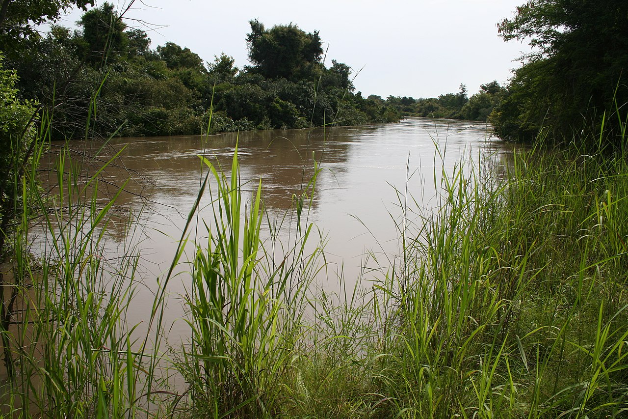
The park is nourished by tributaries including the Mékrou and Tapoa rivers, which cut through sandstone gorges and maintain seasonal pools during the dry season. This hydrological network sustains the largest remaining population of West African elephants (Loxodonta africana), alongside the critically endangered Northwest African cheetah (Acinonyx jubatus hecki), West African lions, roan antelopes, hippopotamuses, and hundreds of migratory bird species. In the gallery forests along the riverbanks, primates including the olive baboon and tantalus monkey thrive alongside Nile crocodiles.
Near the town of Kouré, sixty kilometers east of Niamey, conservation efforts have achieved a remarkable recovery for the West African giraffe (Giraffa camelopardalis peralta). Reduced to fewer than fifty individuals in the late 1990s due to agricultural encroachment and poaching, community-based conservation initiatives have allowed the population to rebound to several hundred animals, which roam freely across communal farmland and brushwood thickets alongside local farmers.
Nomadic Traditions, Identity, and Ceremonial Gatherings
Niger’s cultural landscape is defined by pastoral mobility. The Tuareg, an Amazigh (Berber) people speaking Tamajaq and utilizing the ancient Tifinagh script, have inhabited the northern mountains and desert margins for centuries. Organized into social federations (such as the Kel Ayr and Kel Gres), Tuareg society preserves matriarchal customs; women hold property rights and maintain genealogical knowledge, while men traditionally wear the protective indigo cloth veil (tagelmust) that shields against wind, sun, and malevolent desert spirits.
Another nomadic group is the Wodaabe (a subgroup of the pastoral Fulani or Peul), who herd zebu cattle across the central grasslands of the Sahel. Renowned for their migratory lifestyle and elaborate aesthetic traditions, the Wodaabe celebrate the end of the rainy season in September with the Gerewol festival. During this week-long gathering, young men spend hours painting their faces with yellow ochre and black eyeliner, donning ostrich feathers and cowrie shell necklaces, and performing the hypnotic Yaake dance. Standing shoulder to shoulder, they chant, roll their eyes, and flash white teeth to showcase stamina, physical symmetry, and charm before panels of female judges who select the most handsome suitors.
Daily gastronomy across southern farming communities centers on tuwo, a dense, nourishing dough prepared from ground pearl millet, sorghum, or maize, paired with savory vegetable stews enriched with baobab leaves (miyar kuka), dried okra, and peanut paste. Along desert caravan tracks, nomadic travelers subsist on fura da nono, rolled balls of spiced millet flour dissolved in fermented cow’s or camel’s milk, providing vital electrolytes, proteins, and calories during arduous journeys under the desert sun. Grilled meat traditions flourish around kilishi—seasoned, sun-dried beef or mutton ribbons coated in a paste of ground peanuts, ginger, and chili peppers—which originated as a lightweight, preserved marching ration for cavalry and caravan traders.
In urban centers and agricultural villages, oral literature and musical arts remain central to social cohesion. Songhai and Zarma griots (jasare) recite epic genealogies recounting the exploits of Askia Mohammad and Sonni Ali Ber of the Songhai Empire, accompanied by the molo (a three-stringed lute) and calabash drums. In recent decades, Tuareg musicians from the northern camps near Agadez and Arlit pioneered ‘desert blues’ (Tishoumaren), combining electric guitars with traditional pentatonic rhythms to voice themes of displacement, political struggle, and desert longing, gaining international acclaim through ensembles like Kel Assouf and Bombino.
Extractive Resources and Economic Horizons
Niger’s economy exhibits a dual structure, divided between traditional rain-fed subsistence agriculture and large-scale mineral extraction. The vast majority of the population relies on subsistence farming of pearl millet, sorghum, and cowpeas, combined with pastoral livestock raising. Because agricultural output is tied to erratic rainfall and short four-month growing seasons, food security remains a recurring challenge across the rural Sahel.
Subsurface mineral wealth, however, places Niger in a critical position within global energy markets. In the late 1960s, extensive uranium deposits were discovered around Arlit and Akokan in the northern desert, leading to the development of massive open-pit and underground mining operations operated in partnership with international consortia. For decades, Niger ranked among the world’s leading suppliers of uranium concentrate (yellowcake), providing fuel for nuclear power generation across France and Europe.
In addition to uranium, Niger has developed commercial oil production from the Agadem rift basin in the eastern desert near Diffa. The completion of the nearly two-thousand-kilometer Niger-Benin export pipeline has created a transport conduit connecting the inland oilfields to maritime terminals on the Atlantic coast, offering substantial government revenue potential while reshaping regional energy diplomacy.
Gold mining in the Liptako region along the western frontier, artisanal salt harvesting in the northern oases, and gypsum extraction also contribute to export earnings. However, translating mineral wealth into broad-based economic prosperity remains complicated by transport costs associated with landlocked geography, infrastructure deficits, and price volatility in commodity markets.
Climate Resilience and Future Horizons
Situated in one of the world’s most climate-sensitive zones, Niger faces severe ecological pressures. The expansion of desertification, recurrent droughts, and soil degradation along the Sahelian margin threaten rural livelihoods. In response, Nigerien farmers have pioneered innovative agroforestry techniques, most notably Farmer-Managed Natural Regeneration (FMNR). By protecting and pruning the roots of native drought-resistant trees (such as Faidherbia albida) rather than clearing fields bare, communities have successfully reforested over five million hectares of degraded farmland across Zinder and Maradi, improving soil moisture, boosting crop yields, and capturing atmospheric carbon.
Niger is also an active participant in the Great Green Wall initiative, an ambitious Pan-African project aimed at creating an eight-thousand-kilometer belt of restored land across the Sahel from Senegal to Djibouti. Concurrently, investments in solar power installations and the construction of the Kandadji Dam on the Niger River aim to provide reliable electricity, expand irrigated agriculture, and regulate seasonal water flows against downstream flooding.
From the towering mud-brick minaret of Agadez standing watch over ancient caravan corridors to the sand dunes of the Ténéré and the riverbanks of the Niger, the Republic of Niger endures through the resilience of its people. Rooted in centuries of pastoral adaptation and desert mastery, the nation continues to navigate its challenging environment, building on historical traditions while charting sustainable paths forward across the Sahel.








Share what you know
Been there, grew up there, or know something we missed? Add a comment; corrections with a source are especially welcome.